

View Information About HSR Ratings
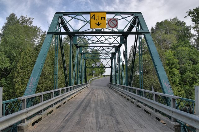
This riveted Pratt through truss crosses a scenic river with rocky edges. Bridge lengths given are extremely rough estimates.
Google Translated Information From Inventory Sheet
A plan of the Lefebvre bridge dates from 1912. Signed by the chief engineer of the Department of Public Works and Work, Louis-A. Vallée, it is marked "revised May 26, 1915". Besides, the profile of the bridge drawn on this plan is not not the one that was built. It has 6 sections rather than 4. Other more complete plans kept at the Ministry of Transports were designed in 1915 and bear the mention of the builders Gauthier and Julien. The current bridge would have presumably been erected that same year. According to historical information, the Lefebvre Bridge was erected in 1914, which corresponds to a year close, to what the plans reveal. The date 1914 may correspond to decisions to go ahead with the construction of the bridge. 1915 as the date of construction remains very plausible. The bridge of the current Lefebvre, probably the third, would be erected in exactly the same location as the two bridges precedents, the first having been built in 1842 and the second probably in 1854 to replace the first structure washed away by the rising water.
The superior heritage value of the Lefebvre bridge is primarily due to its style. It has a Pratt type structure, a specimen widespread in North America between the end of the 19th century and the first decades of the following century. The value of the bridge also lies in its history. Built in 1915 by the builder Gauthier and Julien, a nationally renowned company, it is the third bridge to have been erected in this location. The municipality of Saint-Casimir also has three iron bridges, one of which is in excellent condition authenticity. Finally, the heritage value of the Lefebvre bridge also comes from its context value. It is located in an isolated area, surrounded by vegetation, and crosses the Sainte-Anne river characterized there by rocky escarpments.
![]()
![]()
![]()
Coordinates (Latitude, Longitude):
Search For Additional Bridge Listings:
Additional Maps:
Google Streetview (If Available)
GeoHack (Additional Links and Coordinates)
Apple Maps (Via DuckDuckGo Search)
Apple Maps (Apple devices only)
Android: Open Location In Your Map or GPS App
Flickr Gallery (Find Nearby Photos)
Wikimedia Commons (Find Nearby Photos)
Directions Via Sygic For Android
Directions Via Sygic For iOS and Android Dolphin Browser

© Copyright 2003-2024, HistoricBridges.org. All Rights Reserved. Disclaimer: HistoricBridges.org is a volunteer group of private citizens. HistoricBridges.org is NOT a government agency, does not represent or work with any governmental agencies, nor is it in any way associated with any government agency or any non-profit organization. While we strive for accuracy in our factual content, HistoricBridges.org offers no guarantee of accuracy. Information is provided "as is" without warranty of any kind, either expressed or implied. Information could include technical inaccuracies or errors of omission. Opinions and commentary are the opinions of the respective HistoricBridges.org member who made them and do not necessarily represent the views of anyone else, including any outside photographers whose images may appear on the page in which the commentary appears. HistoricBridges.org does not bear any responsibility for any consequences resulting from the use of this or any other HistoricBridges.org information. Owners and users of bridges have the responsibility of correctly following all applicable laws, rules, and regulations, regardless of any HistoricBridges.org information.
![]()