

View Information About HSR Ratings

On December 6, 2010, Saskatoon City Council voted to demolish the Traffic Bridge.
Canada may have a tie to Great Britain that the United States lacks, but it certainly doesn't show in Saskatoon's treatment of its signature heritage bridge. Canada sadly has far more in common with the wasteful bridge policies of the United States than with the cost-effected, preservation/heritage oriented bridge polices of Great Britain.
The only question which remains is will Saskatoon completely annihilate every trace of this extremely significant heritage bridge, sending the crumpled remains of the bridge to China to be melted down and turned into soup cans, or will Saskatoon at least have the dignity and sense to at least salvage and preserve one of the spans from the bridge in a new location?
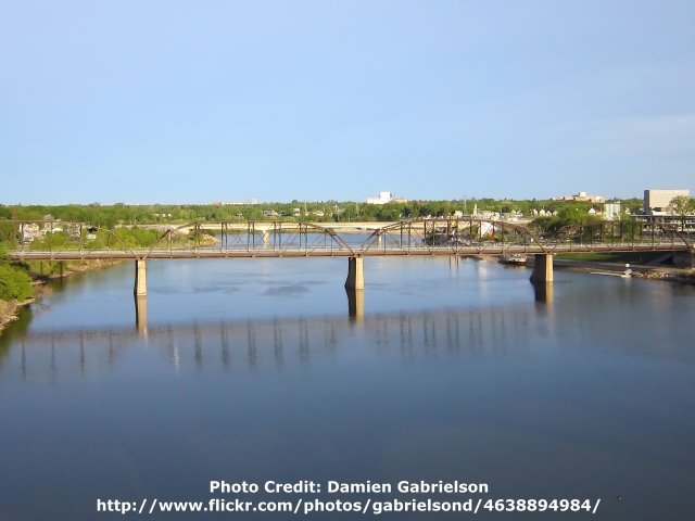
This bridge was designed by the Saskatchewan Department of Public Works. The Traffic Bridge consists of five Parker through truss spans with riveted connections. The bridge is composed of two seven panel spans of 175 feet (56m), one at each end of the bridge, and each of the three central spans contain eight panels forming spans that are 200 feet (64m) long. The substructure includes concrete abutments and piers. The single cantilevered sidewalk on the bridge retains original lattice railings. The sidewalk is technically not original to the bridge, but the bridge hardly was opened to traffic and the need for a sidewalk was realized, so the sidewalk was added soon after.
The substructure of the bridge was built by a well-known Winnipeg contractor, John D. Gunn and Sons Ltd. The truss bridge superstructure was fabricated by the Canadian Bridge Company of Walkerville, Ontario. The on-site superstructure contractor was the McDiarmid Company of Winnipeg.
The Traffic Bridge is not just any heritage bridge. It is one of the most significant heritage bridges in the entire province, which really is saying something because Saskatchewan has some very significant heritage bridges. The Traffic Bridge was the first vehicle bridge built in Saskatoon. Very few cities can actually claim that their first vehicle bridge still remains today. It is the oldest surviving Parker truss in the province. It represented an extremely significant engineering in the Prairies when constructed, being the longest purely traffic bridge in both Saskatchewan and Alberta. The bridge was also the first large steel bridge placed on a concrete substructure, and it also marked the beginning of mandated concrete quality control testing in public works construction in the province. Prior to this time, contractors used whatever concrete mix they wished, and the quality could vary considerably. Finally, in addition to the heritage significance of the Traffic Bridge, there is the aesthetic value of the bridge. Because the bridge has deteriorated, there may be some who look at the bridge today as an eyesore. However, if one can peel back the rust, and imagine a restored Traffic Bridge with a fresh coat of paint on it, perhaps then one can see the reality that this is truly a beautiful signature bridge. A riveted truss bridge like the Traffic Bridge is a work of geometric art, from the complexity of the trusses and bracing that compose the overall superstructure, to the smaller elements like the attractive v-lacing that holds the built-up vertical members of the truss together and the lattice that composes the railing and the portal bracing. All of these parts are held together by rivets, which themselves add accent to the appearance of the bridge with their button-shaped heads.
On August 24, 2010 the Traffic Bridge was closed to traffic following a bridge inspection that revealed deterioration on the bridge. It appears the closure was due to deterioration in the typical areas of a truss bridge, along the bottom chord and bottom chord connections, flooring system, and deck. These areas are in what is called the splash zone, which are subjected to excessive moisture and dirt from the traffic on the bridge. In response to the closure, the City of Saskatoon began to study options (alternatives) to address the problems discovered with the bridge. The alternatives initially covered a long range of options that were considered at a casual level and then quickly narrowed down to four options. Once these four options were selected for further in-depth consideration, the City of Saskatoon also created a forum to solicit public discussion and input on the four options being considered. This public input will be used to guide the study and project development process that will ultimately determine whether one of the most significant heritage bridges in Saskatchewan is preserved or demolished. The four options under consideration are shown in the box below.
Traffic Bridge Project Options Submitted For Public CommentThe below options in this box are provided exactly as worded by the City of Saskatoon. These statements below do not necessarily reflect the views of HistoricBridges.org. Option 1: Complete rehabilitation for vehicle, pedestrian and cyclist use: Maintain the bridge in its existing form and function, providing narrow traffic lanes (2.9 metres) but replace the existing separate pedestrian walkway on the west side of the bridge with two standard width walkways (3 metre) on both sides. [Concept probable cost: $27 million]Option 4: Replace with a conventionally designed structure (girder and deck) for vehicle, pedestrian and cyclist use: A new structure providing two standard width traffic lanes (3.7 metre plus 1.4 metre shoulder) and separate 3 metre shared walkways on both sides. Likely a concrete bridge. [Concept probable cost: $26 million] Option 5: Replace with a modern steel truss or similar form to the existing bridge for vehicle, pedestrian and cyclist use: A new structure providing two non-standard width traffic lanes (3.3 metre), no shoulders and separate 3 metre shared walkways on both sides. [Concept probable cost: $25 million] Option 6:: Replace with an architecturally significant structure for vehicle, pedestrian and cyclist use, a modern "signature bridge": A new design providing two standard width traffic lanes (3.7 metre plus 1.4 metre shoulder) and 3 metre shared walkways on both sides. [Concept probable cost: $60 million] View A PDF With Details On These Options |
In response to this solicitation for public input, HistoricBridges.org's author and webmaster, Nathan Holth, provided the following responses and comments to the city to represent the official opinion and position of HistoricBridges.org in regard to the proposed project options. The hope is that the below comments in the remainder of this section of the page will show both the City of Saskatoon and the general public of the importance of the Traffic Bridge and why its preservation is important, and also the feasibility of preservation.
I am the author and webmaster of historicbridges.org and have been following the Traffic Bridge in the news very closely. In the process of documenting and advocating for the preservation of the over 2000 bridges featured on the website in the United States and Canada, I have gained valuable experience and insight relating to the preservation of bridges with heritage value, having seen many different approaches to a successful preservation project. While I sorely regret that I have not been able to personally visit Saskatchewan's beautiful heritage bridges, I have studied the Government of Saskatchewan's 2007 inventory and heritage assessment of the province's pre-1950 bridges, and am aware that the Traffic Bridge sits at the forefront of Saskatchewan's rich collection of heritage bridges. I have a number of comments and recommendations. I am in support of any option that preserves the existing heritage bridge.
For all of these reasons, the preservation of the existing Traffic Bridge is essential. No modern bridge can take the place of the value and beauty that the existing heritage bridge provides Saskatoon.
It is often said that haste makes waste. To that end, I question the decision of the council to narrow the alternatives under consideration to the current four alternatives before some of the other alternatives were fully considered in a more complete and in-depth study. In particular, I suspect that the option to convert the bridge to a facility for non-motorized traffic only could have been redesigned to cost far less than the initial estimate suggested. Furthermore, I would recommend the addition of another option, which would be a one-way couplet of bridges. This would involve the construction of a new one-lane bridge next to the existing bridge to carry one way vehicular traffic, while the existing bridge would carry the other direction of vehicular traffic, and also non-motorized traffic. This option might reduce the loading requirements for the existing bridge, thus reducing rehabilitation cost, and the one-lane new bridge would likely cost less than a large two-lane replacement bridge. The new one-lane bridge could be a simple concrete or steel structure, which would have a low profile and would provide a clear visual difference between the heritage structure and the modern structure. Alternatively, the new one-lane bridge could also be a metal truss bridge of similar profile, so that the two bridges visually line up with each other, similar to the Low Level Bridge in Edmonton, Alberta.
Among the options that are currently being considered, I strongly support the adoption of Option 1 as the preferred option, which is a complete rehabilitation for vehicle, pedestrian and cyclist use. This is the only option that will retain all of the benefits which I discussed previously in my general introductory comments, and for that reason I believe this is the best of the currently available options. Further, I strongly urge the city to spend some serious time seeking out a firm that has proven experience in developing high-quality rehabilitation projects. Far too often, I have seen bridges demolished and replaced instead of being rehabilitated simply because the proposed rehabilitation was developed by a firm with little preservation experience, resulting in an overly expensive rehabilitation that also yielded an overly short estimated post-rehabilitation bridge service life. Also, a firm with proven experience in preservation work will also understand the importance of developing a rehabilitation project that focuses on retaining as much original bridge material as possible, as well as making sure that any parts on the bridge are replaced in-kind rather than with some other modern alternative, so that the historic integrity of the bridge is maintained.
I consider Option 5: Replace with a modern steel truss or similar form to the existing bridge for vehicle, pedestrian and cyclist use to be one of the two least appealing options. First, the description for this option is extremely misleading. Modern truss bridges do not look like the existing Traffic Bridge. Many of the key features in the existing Traffic Bridge almost certainly would not be present in a modern truss bridge. For example, modern truss bridges are either bolted or welded, and they do not contain rivets. The beams that compose the truss would likely be rolled beams, and would not have the attractive v-lacing and battens that give the existing bridge its attractive lightweight and complex appearance. To demolish the existing Traffic Bridge and replace it with a modern truss bridge implies that the goal is to have the new bridge fill the shoes of the existing bridge in terms of aesthetics and heritage. However, such a line of thought is little more than an insult to the existing bridge's value. A modern bridge will have no heritage value whatsoever, and the aesthetic value will be dramatically reduced because the historical construction and design techniques that are not employed in modern truss construction.
Option 6: Replace with an architecturally significant structure for vehicle, pedestrian and cyclist use, a modern "signature bridge" is in my opinion the other least appealing option, simply because the cost-benefit simply does not work out. The reality is, that if the existing heritage bridge were rehabilitated, the end result of having one of the most significant heritage bridges in the province in a state of sparkling beauty, would be nothing less than a signature bridge for Saskatoon. So if the desire is to provide Saskatoon with a "signature bridge" than the rehabilitation of the existing bridge to provide a heritage signature bridge, costing half the cost of a modern signature bridge, seems much more appropriate from a fiscal standpoint.
As a compromise solution, I suggest that Option 4: Replace with a conventionally designed structure (girder and deck) for vehicle, pedestrian and cyclist use c could be modified to provide a good compromise. It would be possible to salvage and modify the trusses of the existing Traffic Bridge to fit and mount them on top of a replacement girder bridge for decorative, non-structural purposes. Such a solution can be seen in the Bloomsbury Bridge in New Jersey. In this solution, the benefits of a modern bridge can be realized, while still salvaging and retaining a part of the original heritage bridge's materials. I really think that the rehabilitation option is the best option, but if for some reason this option cannot be realized, than this makes a good alternative compromise solution.
Finally, I recommend that the city conduct an archival quality photo-documentation of the existing Traffic Bridge prior to the execution of any of the proposed options. A photo-documentation would include photos of the bridge as a whole, as well as construction details of the bridge. These archival-quality photos would serve as a permanent historical record of the bridge, which would be important in ensuring that this significant heritage bridge is never forgotten, regardless of what option is ultimately selected. Indeed, I noted that a class of 4th and 5th grade students was able to come up with the suggestion to photo-document the bridge on their own, according to a forum post on www.saskatoontrafficbridgeforum.ca. This would indeed be a worthy course of action. These 4th and 5th grade students also had another valid suggestion. If the unthinkable truly does occur, and this beautiful heritage bridge is actually demolished, than some parts of the bridge should be salvaged and placed in a museum exhibit, such as at the Western Development Museum.
Saskatchewan is home to a diverse collection of heritage bridges that ranges from metal truss bridges such as the Traffic Bridge to a noteworthy collection of concrete bowstring "rainbow" arch bridges. Because of the size of the province and the rural nature of much of the province, these bridges are spread out over great distances. The same can be said for the other Prairie provinces as well. The total number of heritage bridges in a particular region of the province might be very small as a result. As a large city, Saskatoon has more heritage bridges that most areas of Saskatchewan. However, the fact remains that the total number of heritage bridges in even this area is relatively small. As such, the loss of even one heritage bridge can be a profound loss indeed for the affected region. For a bridge as significant as the Traffic Bridge, the loss would be all the more great. The Traffic Bridge deserves preservation.
Information and Findings From Saskatchewan's Heritage Bridge InventoryCompiled For Government of Saskatchewan By Ross Herrington M.A., M. Sc., P. Eng. Architectural Historian Statement of Significance The Traffic Bridge, located in Saskatoon, connects Victoria Avenue on the east side of the South Saskatchewan River with 3rd Avenue South in the downtown core. The bridge, which was opened in October, 1907, consists of five steel through-truss spans on concrete piers and abutments. Heritage Value The heritage value of the bridge lies in its status as a prominent feature of Saskatoon's urban landscape and an important community landmark. This structure was the first vehicle bridge over the South Saskatchewan River within Saskatchewan and was the catalyst in the creation of the Saskatoon Board of Trade and Saskatoon itself. In 1905, the Town of Saskatoon proposed to the Villages of Nutana and Riversdale that the three communities amalgamate to become a city. Nutana ratepayers insisted that a traffic bridge across the river be built as soon as possible otherwise they saw no benefit to amalgamation. Funding of the bridge was approved at the first session of the provincial legislature in 1905 when Saskatchewan became a province. Without this bridge, the city of Saskatoon could not have developed as quickly as it did. The heritage value of the structure also resides in its technology. The
bridge was constructed in 1907 from plans provided by the Canadian Bridge
Company. It is the oldest surviving steel Parker through-truss in the province
and at the time of construction, it was the longest purely traffic bridge in
existence in either Saskatchewan or Alberta. Steel through-trusses made their
appearance in Saskatchewan in 1900 and represented a significant engineering
advance over earlier timber bridge structures. The structure remains largely
unchanged and except for short periods for rehabilitation, the bridge has been
in continual use by vehicles and pedestrians since its completion in 1907. The heritage value of the bridge is also connected to the establishment of a scientifically-based, cement-testing laboratory by the provincial government. Previously, contractors supplied their own cement and there were no quality control procedures in place. This testing facility ensured that only first-class cement would be used in future provincially-funded projects, including the replacement of piles under steel bridges with concrete piers, and the construction of many public buildings throughout the province. Character-Defining Elements The heritage value of the Traffic Bridge resides in the following
character-defining elements: Historical Significance In the late 1870s, Prime Minister John A. Macdonald's government was enthusiastically promoting the settlement of western Canada by offering large blocks of land to colonization companies. In 1881 a group of Toronto Methodists formed the Temperance Colonization Society (TCS) and was granted a 65km long block of land along the South Saskatchewan River. The TCS chose a settlement site on the east bank near the mid-point of this tract where a ferry could cross the river, and named their community ‘Saskatoon'. The first streets of Saskatoon were surveyed in 1883. In 1890, the Qu'Appelle, Long Lake and Saskatchewan Railway line to Prince Albert bridged the river where the Idylwyld Freeway now stands. A new settlement soon developed on the west side of the river around the railway station. By 1901 this settlement incorporated as the Village of Saskatoon and the name of the original settlement on the east bank was changed to Nutana. A third settlement, Riversdale, developed west of the railway tracks on the west side of the river. Access between east and west sides of the river presented problems for the early settlers. A ferry began operating in 1884 between Victoria Park and the foot of Main Street. This was moved in 1890 to a site just below the railway bridge. The seasonal ferry service was often unreliable due to vagaries of the river and walking across the railway bridge could be dangerous. At a meeting held in Saskatoon on October 25, 1902 to discuss the ferry problem, local real estate developer, Allen Bowerman, recommended that a Board of Trade be formed to pressure the government for a traffic bridge.1 Saskatoon's Board of Trade held its first meeting on January 21, 1903; two of its initial priorities were to improve the ferry service in the short term and lobby for a traffic bridge.2 Since the CPR was proposing to replace their old wooden Howe truss bridge at Saskatoon, in the fall of 1903 the Board of Trade lobbied both the Dominion and Territorial governments for a combined rail and traffic bridge. A lukewarm response and subsequent delays prompted the business community to open up direct discussions with the CPR. This was well-received since the CPR and the Qu'Appelle, Long Lake & Saskatchewan Railway were planning to jointly erect a permanent steel railway bridge at Saskatoon. Vehicular and pedestrian attachments could be added to their design and this would be supported financially by the Territorial government. Unfortunately for Saskatoon, after new concrete bridge piers were completed, the QLL & S line was up for sale. The CPR backed away and simply re-installed the old Howe truss on the new piers.3 Saskatoon remained without a traffic bridge at the time Saskatchewan became a province in 1905. At a meeting of the Saskatoon Town Council in April, 1905, the suggestion was made that Saskatoon unite with the villages of Nutana and Riversdale to become a city.4 Public meetings were held in June and July. At a meeting in December, Nutana ratepayers insisted that a traffic bridge across the river be built as soon as possible otherwise they saw no benefit to amalgamation. Without this bridge, the city of Saskatoon could not have developed as quickly as it did.5 Funding of the bridge was approved at the first session of the provincial legislature in 1905 when Saskatchewan became a province, along with two other large bridges, the Canadian Northern Railway Bridge at Prince Albert and the traffic bridge at Battleford. The latter bridge was similar to Saskatoon's steel through-truss Traffic Bridge and was completed in 1909. The site selected for Saskatoon's Traffic Bridge "is without doubt the cheapest, most serviceable and most picturesque location for a considerable distance."6 Construction of the bridge began in August 1906 and the bridge was opened officially on October 10, 1907. At the time of construction, it was the longest purely traffic bridge in existence in either Saskatchewan or Alberta, and was of such significance that Lieutenant-Governor Forget officiated at its opening ceremony. The Traffic Bridge was the first dedicated vehicle bridge over the South Saskatchewan River and remained Saskatoon's only vehicle and pedestrian bridge until the University Bridge was opened in 1916. In June 1908, the steamship, City of Medicine Hat, struck one of the bridge piers and capsized. Fortunately, everyone was safely rescued. A second significant incident occurred on March 3, 1922 when Streetcar #4 jumped the track at the sharp turn onto the east approach to the bridge and landed on the bank below. Six passengers were seriously injured. The bridge was closed to vehicular traffic between November, 2005 and September 2006 due to serious corrosion problems and other factors. The condition of the bridge has since been stabilized and it is estimated that its current useful life has been extended until at least 2025. In funding the construction of the Traffic Bridge, the provincial government recognized that the new settlement of Saskatoon had become a significant urban centre. The bridge united three separate communities and would enhance Saskatoon's control of local trade and ensure its continued growth. It is curious that Saskatoon's first traffic bridge was the last to be officially named. Known variously as the Traffic Bridge, Victoria Bridge, Black Bridge, Short Hill Bridge, or 19th Street Bridge, the city conferred the name "Traffic Bridge" on this century-old structure on April 22, 2007. Engineering Significance The first steel through-truss in Saskatchewan was constructed over the Assiniboine River near Pelly in 19007 (since demolished). Although significant in its day, this bridge was a relatively modest structure with a clear span of 80 feet (25m). The provincial Department of Public Works constructed four similar steel truss bridges in southeastern Saskatchewan during the next five years: over the Souris River in 1901 (50-foot span) and 1904 (125-foot), and two bridges over Pipestone Creek in 1905 (80-foot and two 50-foot spans). These structures either have been replaced by reinforced concrete structures or the truss has been modified significantly. In its 1907 Annual Report (p.106) , the provincial Department of Public Works stated that "The future policy of the Department should be to construct heavy steel bridges rather than light steel or timber bridges on account of the more permanent nature of the structures." In addition, to reduce the frequency of crews doing repairs and therefore reducing overall costs, "Whenever possible in future all steel bridges constructed should permit of a future concrete roadway, concrete piers and abutments…" Saskatoon's Traffic Bridge was the first large steel bridge in Saskatchewan placed on concrete foundations at the time of construction. Regarding the philosophy of future concrete roadways, it is interesting to note that a year later, the Department had come to the realization that "this immense dead weight of concrete in the floors added too much to the already heavy bridges required to carry the great concentrated wheel loads of traction engines, and the idea of providing for concrete floors, generally was abandoned."8 Before standardization of designs, bridge building in the early years was often an experimental process. Saskatoon's Traffic Bridge is the oldest surviving steel Parker through-truss in the province. It was designed by the provincial Department of Public Works9 and consists of two 175 feet (56m) spans with three central spans each 200 feet (64m) long on concrete piers and abutments. The substructure contract was awarded to prominent Winnipeg contractor, John D. Gunn and Sons Ltd., who, among other significant projects, was responsible for the 1910-1913 CPR High Level Bridge over the North Saskatchewan River at Edmonton. The steel superstructure was fabricated at the Canadian Bridge Company plant in Walkerville (now Windsor), Ontario and erected by the McDiarmid Company of Winnipeg. While the concrete piers were completed in late 1906, a delay in getting the fabricated steel from the rolling mills, combined with having to wait until after the 1907 spring breakup to permit the erection of falsework, the work of erecting the steel superstructure was not started until June 1, 1907.10 The initial floor was laid by October 1. Shortly after the bridge was opened, it became apparent that a sidewalk was urgently needed. A six-foot (2m) wide sidewalk was attached by steel brackets to the upstream side of the bridge in 1908.11 A planned addition on the downstream side of the bridge for a street railway was not implemented. A permanent floor was laid during the 1910 construction season. It consisted of "two plys of two inch creosoted plank on top of which was placed a sand and cement cushion; on this two and a quarter inch asphalt blocks were laid to form the road surface."12 It is not known how well this "light serviceable road" performed. The design of bridges during this early settlement period required consideration of the passage of large boats. For example, in the case of Battleford's first traffic bridge, completed in 1909, a sufficiently deep channel was selected between an island and one shore to provide clearance for boats by raising 600 feet (191m) of the bridge to the high level. The Canadian Northern Railway Bridge at Prince Albert (1909) was designed with a central swing-span which could be opened to allow passage of vessels. Similarly, after some debate, the Grand Trunk Pacific Bridge over the South Saskatchewan River at St. Louis (1912) was constructed with provision for a central lift-span. It is not known if Saskatoon's Traffic Bridge was initially conceived with a moveable section but none was installed. One of the far-reaching, province-wide outcomes of building the Saskatoon Traffic Bridge in 1907 (and the Battleford traffic bridge) was the recognition by the provincial Department of Public Works that the quality of cement used in constructing concrete piers needed to be controlled. Previous to this, contractors supplied their own cement, "some of which are new and unknown and many of foreign manufacture."13 A cement-testing laboratory was subsequently formed. This testing facility ensured that only first-class cement would be used in future DPW work, including the replacement of pile piers under steel bridges with concrete piers, and the construction of various public buildings throughout the province. Footnotes / Sources 1 1 Saskatoon Phenix, October 31, 1902, p.1. |
![]()
![]()
![]()
This historic bridge has been demolished. This map is shown for reference purposes only.
Coordinates (Latitude, Longitude):
Search For Additional Bridge Listings:
Additional Maps:
Google Streetview (If Available)
GeoHack (Additional Links and Coordinates)
Apple Maps (Via DuckDuckGo Search)
Apple Maps (Apple devices only)
Android: Open Location In Your Map or GPS App
Flickr Gallery (Find Nearby Photos)
Wikimedia Commons (Find Nearby Photos)
Directions Via Sygic For Android
Directions Via Sygic For iOS and Android Dolphin Browser

© Copyright 2003-2024, HistoricBridges.org. All Rights Reserved. Disclaimer: HistoricBridges.org is a volunteer group of private citizens. HistoricBridges.org is NOT a government agency, does not represent or work with any governmental agencies, nor is it in any way associated with any government agency or any non-profit organization. While we strive for accuracy in our factual content, HistoricBridges.org offers no guarantee of accuracy. Information is provided "as is" without warranty of any kind, either expressed or implied. Information could include technical inaccuracies or errors of omission. Opinions and commentary are the opinions of the respective HistoricBridges.org member who made them and do not necessarily represent the views of anyone else, including any outside photographers whose images may appear on the page in which the commentary appears. HistoricBridges.org does not bear any responsibility for any consequences resulting from the use of this or any other HistoricBridges.org information. Owners and users of bridges have the responsibility of correctly following all applicable laws, rules, and regulations, regardless of any HistoricBridges.org information.
![]()