

View Information About HSR Ratings
2020 Update: This bridge has been closed to all traffic and its future is uncertain. See this news article.
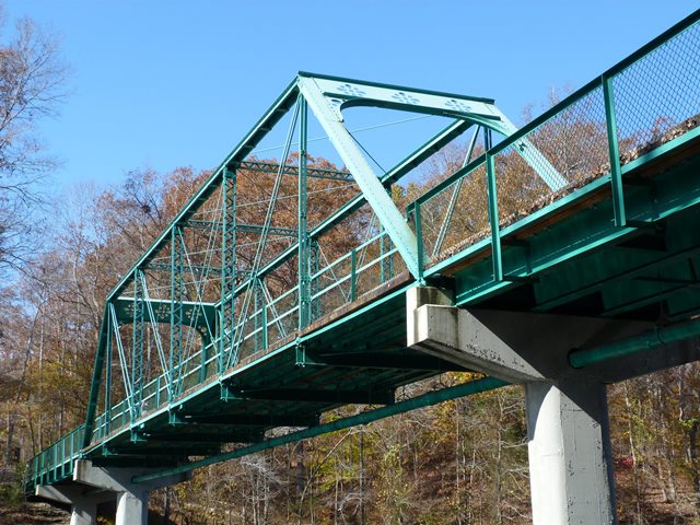
This bridge was originally built at Dabbs Ford over the Elk River on the Franklin-Coffee County line on the Prairie Plains to Winchester Road. In 1970 the bridge was replaced and the truss spans was relocated here to the Old Stone Fort State Park by the Tennessee Department of Conservation. New piers and approach spans were constructed at this new location. The bridge was last rehabilitated in 2009.
The truss span is noteworthy as a work by the Joliet Bridge and Iron Company. Although a fairly prolific bridge builder, it is a rare company among Tennessee's surviving bridges. The bridge is also noteworthy for its ornamental portal bracing. The ornamental cutouts in the portal bracing plates were cut out in the era before cutting torches and instead a series of tiny holes were drilled next to each other to cut the metal out. This can be seen looking at the detail of the cutouts. A lot of work just to produce some ornamentation.
There were some welded alterations found on the truss such as at eyebar heads, and also a weird welded alteration apparently intended to replace a pin nut. Otherwise, the historic integrity of the truss is good.
![]()
![]()
![]()
Coordinates (Latitude, Longitude):
Search For Additional Bridge Listings:
Bridgehunter.com: View listed bridges within 0.5 miles (0.8 kilometers) of this bridge.
Bridgehunter.com: View listed bridges within 10 miles (16 kilometers) of this bridge.
Additional Maps:
Google Streetview (If Available)
GeoHack (Additional Links and Coordinates)
Apple Maps (Via DuckDuckGo Search)
Apple Maps (Apple devices only)
Android: Open Location In Your Map or GPS App
Flickr Gallery (Find Nearby Photos)
Wikimedia Commons (Find Nearby Photos)
Directions Via Sygic For Android
Directions Via Sygic For iOS and Android Dolphin Browser
USGS National Map (United States Only)
Historical USGS Topo Maps (United States Only)
Historic Aerials (United States Only)
CalTopo Maps (United States Only)

© Copyright 2003-2025, HistoricBridges.org. All Rights Reserved. Disclaimer: HistoricBridges.org is a volunteer group of private citizens. HistoricBridges.org is NOT a government agency, does not represent or work with any governmental agencies, nor is it in any way associated with any government agency or any non-profit organization. While we strive for accuracy in our factual content, HistoricBridges.org offers no guarantee of accuracy. Information is provided "as is" without warranty of any kind, either expressed or implied. Information could include technical inaccuracies or errors of omission. Opinions and commentary are the opinions of the respective HistoricBridges.org member who made them and do not necessarily represent the views of anyone else, including any outside photographers whose images may appear on the page in which the commentary appears. HistoricBridges.org does not bear any responsibility for any consequences resulting from the use of this or any other HistoricBridges.org information. Owners and users of bridges have the responsibility of correctly following all applicable laws, rules, and regulations, regardless of any HistoricBridges.org information.
![]()