

View Information About HSR Ratings
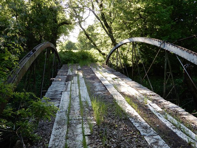
This bridge is one of only a few cast and wrought iron bowstring truss bridges surviving in Texas today. This example is an example of the King Iron Bridge Company's patented bowstring design and enjoyed popularity in the 1870s. Compared to other bowstring bridges of similar design, this bridge has unusually heavy riveted built-up floorbeams suggesting that this bridge is either a later example of this bridge type, or had its floorbeams replaced long ago when riveted floorbeams were still common.
The top chord channel of this bridge has rare Passaic Rolling Mill Company brands on it.
Unfortunately the abutment of this bridge is failing causing the truss to drop. The bridge is at severe risk for collapse. The county tied a wire cable tied to a tree and the bridge to try to keep bridge from collapsing. This cable was under extreme tension. The bridge is closed to traffic and the county plans to demolish the bridge if a new owner who wants to relocate the bridge cannot be found.
![]()
![]()
![]()
This historic bridge has been relocated and is no longer at this location. See the main bridge page for a link to the new bridge location. This map is shown for reference purposes only.
Coordinates (Latitude, Longitude):
Search For Additional Bridge Listings:
Bridgehunter.com: View listed bridges within 0.5 miles (0.8 kilometers) of this bridge.
Bridgehunter.com: View listed bridges within 10 miles (16 kilometers) of this bridge.
Additional Maps:
Google Streetview (If Available)
GeoHack (Additional Links and Coordinates)
Apple Maps (Via DuckDuckGo Search)
Apple Maps (Apple devices only)
Android: Open Location In Your Map or GPS App
Flickr Gallery (Find Nearby Photos)
Wikimedia Commons (Find Nearby Photos)
Directions Via Sygic For Android
Directions Via Sygic For iOS and Android Dolphin Browser
USGS National Map (United States Only)
Historical USGS Topo Maps (United States Only)
Historic Aerials (United States Only)
CalTopo Maps (United States Only)

© Copyright 2003-2026, HistoricBridges.org. All Rights Reserved. Disclaimer: HistoricBridges.org is a volunteer group of private citizens. HistoricBridges.org is NOT a government agency, does not represent or work with any governmental agencies, nor is it in any way associated with any government agency or any non-profit organization. While we strive for accuracy in our factual content, HistoricBridges.org offers no guarantee of accuracy. Information is provided "as is" without warranty of any kind, either expressed or implied. Information could include technical inaccuracies or errors of omission. Opinions and commentary are the opinions of the respective HistoricBridges.org member who made them and do not necessarily represent the views of anyone else, including any outside photographers whose images may appear on the page in which the commentary appears. HistoricBridges.org does not bear any responsibility for any consequences resulting from the use of this or any other HistoricBridges.org information. Owners and users of bridges have the responsibility of correctly following all applicable laws, rules, and regulations, regardless of any HistoricBridges.org information.
![]()