

View Information About HSR Ratings
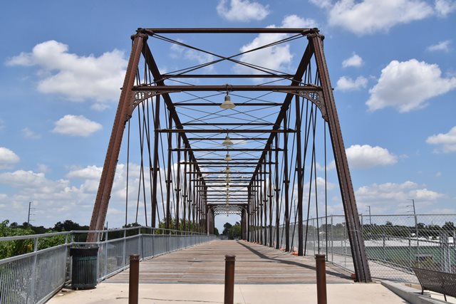
This bridge has been preserved in place for pedestrian use. It consists of a Whipple truss span with Phoenix columns, making it an extremely significant bridge for Texas where this type is extremely rare. The bridge also has a Pratt through truss span. The remaining spans are concrete spans that were replaced with new spans when the truss spans were preserved. Overall, the truss spans retain good historic integrity. One exception is the replacement of the sway bracing Phoenix columns. The sway bracing columns reportedly were steel replacements from 1910 and thus more susceptible to rust than the original wrought iron columns. These were replaced in the 2010 project with modern steel pipe with little plates/bars welded to them to make them look like Phoenix columns. However, because nobody put rivets on the little plates, they stand out visually (at least to bridge historians) as modern replacements. The new approach spans, while modern, were designed to try to respect the appearance of the original spans.
Narrative By Restoration Engineer Patrick Sparks, 2007:
The 1881/1910 Hays Street Bridge is a viaduct consisting of two wrought iron truss spans (one Phoenix Whipple 225-ft span, and one Pratt 130-ft span), and approximately 1000-LF of concrete approaches.
In 1910, the City of San Antonio required the Galveston, Harrisburg & San Antonio Railway Co. (eventually part of Southern Pacific) to construct a viaduct over the railroad tracks at Hays Street. The railway company relocated the two truss spans from elsewhere
on its lines.
Records of the Phoenix Bridge Company [1] archived at the Hagley Library in Wilmington, Delaware show that the Whipple truss dates from 1881 and was reconstructed from salvaged spans over the Nueces River west of San Antonio. These records include entries in the company’s customer index as well as copies of the 1910 repair shop drawings showing replacement joint blocks, bearing seats, and lateral bracing struts. Both spans were widened from about 16-feet to the current 25-feet.
The Whipple truss span is a Phoenix patent design using the now rare Phoenix segmental wrought iron columns with cast-iron joint blocks. This bridge was Customer Order 1460, as evidenced by the stamp on the joint blocks and tubular sections, and dated 1881 in the ledger of the Phoenix Company.
The Pratt span is also wrought iron and has Phoenix-branded components, including the floor beams. It is likely an approach span from the same original river crossing as the Whipple span as it has exactly the same original width and is a type that was being made by Phoenix in 1881; however, it may have been taken from another location.
The bridge was rehabilitated as a bicycle and pedestrian facility by the City of San Antonio, using a Transportation Enhancement grant from the Texas Department of Transportation. Sparks Engineering, Inc. was the design consultant for the project. Plans and specifications were completed in November 2006 and the project was finished in 2010 [2].
Notes
[1] Hagley Library, Wilmington, DE:
Records of the Phoenix Bridge Co.
Index of Orders, No. 2, pg. 61
Series F/C.O. 582/April 9/’10/Hays St. Viaduct at San Antonio, Texas:
1 Roller Foot “R.R.”, 1 Wall Plate “F.P.” & 22 Phx Col. Struts for Alteration of 1-225’ Thro’
Span from Nueces R. Bridge (O. 1372), to be widened fr. 16’ to 25’ and re-erected as a Highway
Span/Engineer in Charge: MGL/
“ “/C.O. 623/Sep. 10,’10/Repair of Old 225’ Phoenix Thro’ Span, C.O. 1460 (built in 1881) 1
Inter. Top Chord Casting/Engineer in Charge: F. Geo. Lippert/
[2] “Ironclad” Civil Engineering Magazine, American Society of Civil Engineers, August 2010
This bridge is tagged with the following special condition(s): Phoenix Columns
![]()
![]()
![]()
Coordinates (Latitude, Longitude):
Search For Additional Bridge Listings:
Bridgehunter.com: View listed bridges within 0.5 miles (0.8 kilometers) of this bridge.
Bridgehunter.com: View listed bridges within 10 miles (16 kilometers) of this bridge.
Additional Maps:
Google Streetview (If Available)
GeoHack (Additional Links and Coordinates)
Apple Maps (Via DuckDuckGo Search)
Apple Maps (Apple devices only)
Android: Open Location In Your Map or GPS App
Flickr Gallery (Find Nearby Photos)
Wikimedia Commons (Find Nearby Photos)
Directions Via Sygic For Android
Directions Via Sygic For iOS and Android Dolphin Browser
USGS National Map (United States Only)
Historical USGS Topo Maps (United States Only)
Historic Aerials (United States Only)
CalTopo Maps (United States Only)

© Copyright 2003-2026, HistoricBridges.org. All Rights Reserved. Disclaimer: HistoricBridges.org is a volunteer group of private citizens. HistoricBridges.org is NOT a government agency, does not represent or work with any governmental agencies, nor is it in any way associated with any government agency or any non-profit organization. While we strive for accuracy in our factual content, HistoricBridges.org offers no guarantee of accuracy. Information is provided "as is" without warranty of any kind, either expressed or implied. Information could include technical inaccuracies or errors of omission. Opinions and commentary are the opinions of the respective HistoricBridges.org member who made them and do not necessarily represent the views of anyone else, including any outside photographers whose images may appear on the page in which the commentary appears. HistoricBridges.org does not bear any responsibility for any consequences resulting from the use of this or any other HistoricBridges.org information. Owners and users of bridges have the responsibility of correctly following all applicable laws, rules, and regulations, regardless of any HistoricBridges.org information.
![]()