

View Information About HSR Ratings
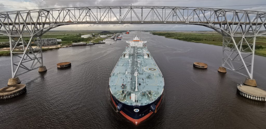
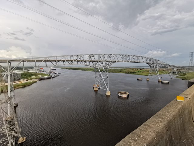
The Rainbow Bridge is one of the most significant and unique bridges in Texas. It is one of the earliest bridges in the country to display a variation of a cantilever truss that is often called an "arch cantilever" in reference to the smoothly curved trusses that have none of the traditional pointy towers often found in cantilever through truss bridges. However this bridge has some additional unique details, in particular its triangular steel bents, carefully designed to protect this very tall bridge from hurricane force winds that may occur in this coastal location. The bridge has distinctive and beautiful triangular bents that lend stability to the bridge. The bridge's height (176 feet of navigation vertical clearance) allows for the large ships that utilize the waterway to pass under. Its approaches have a very striking, steep appearance to them because of the surrounding landscape being perfectly flat. The approaches are also perfectly straight, making them more imposing than the approaches for similar bridges, such as the Blue Water Bridge (150 foot navigation vertical clearance) which has curved approaches. The Blue Water Bridge is also worth mention as a notable comparison as it is also an early high level arch-shaped cantilever truss built around the same time, on a similarly flat landscape, but which did not need to be designed for hurricane force winds. Also, both the Blue Water Bridge and the Rainbow Bridge have been turned into one-way couplets with a new bridge having been constructed next to them. In the case of the Rainbow Bridge, the companion bridge is a cable-stayed bridge.
The state highway engineer corresponded with noted engineer Frank Masters of Modjeski and Masters (who also designed the aforementioned Blue Water Bridge), in regards to the high level design of the bridge. Ultimately however, it was Ash, Howard, Needles, and Tammen who were the consulting engineers for this bridge.
The Rainbow Bridge has been well-maintained and is in good condition today. Some rivets appear to have been replaced with bolts, but otherwise the bridge retains excellent historic integrity.
See the above linked National Register Nomination for a detailed history and sketch of the bridge layout.
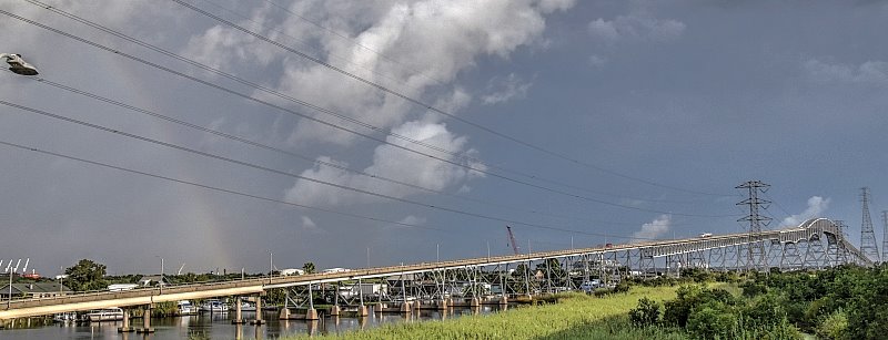
Above: A faint rainbow visible at the Rainbow Bridge!
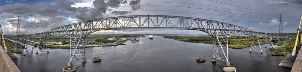
Information and Findings From Texas Historical CommissionMarker Text Jefferson County The rapid growth of the petrochemical industry in Jefferson and Orange counties in the early 20th century led to increased population in this area. In order to serve escalating transportation needs, plans began in the 1920s for the construction of a bridge to span the Neches River. Due to the depressed economy and differences of opinion among business leaders, the campaign to build the bridge (led by the Port Arthur "News" and American Legion Post No. 7) lasted for seven years. In 1934 Gov. Miriam A. Ferguson signed a special law to enable county bond and Federal Public Works Administration funds to pay for state highway bridge construction. The project engineer, G. G. Wickline, used innovative techniques to design a bridge that would cross 7,742 feet of marshy terrain and river bottom. The bridge's 680-foot central span, designed to clear a Navy ship carrying a moored dirigible, was, at 176 feet, the world's highest elevated roadbed over tidal waters. The final cost of the bridge was $2,750,000. Its dedication on September 8, 1938, drew huge crowds and was a major local event. In a 1957 contest sponsored by the North Port Arthur Lions Club, it was named "Rainbow Bridge." Marker Text Orange County The rapid growth of the petrochemical industry in Orange and Jefferson counties in the early 20th century led to increased population in this area. In order to serve the transportation needs of workers and others in this vicinity, the Dryden ferry was established in 1926. It soon proved inadequate for the volume of traffic, however, and plans began for the construction of a bridge to span the Neches River. Jefferson County, the State of Texas, and the Federal government (through the Public Works Administration) all provided funding for the bridge's construction. While the citizens of Orange County also supported the project, the county's economic situation did not permit monetary assistance. Construction of the bridge began in 1936, and was not completed until over two years later. Measuring 176 feet in height and 7760 feet in length, it was the largest bridge ever built by the State of Texas up to that time. Dedication ceremonies were held on Sept. 8, 1938, attracting a crowd of approximately 20,000. Among the activities were a boat regatta on the river and a stunt diver's plunge from the top of the bridge into the water below. The structure was officially named "Rainbow Bridge" in a 1957 contest. |
![]()
![]()
![]()
Coordinates (Latitude, Longitude):
Search For Additional Bridge Listings:
Bridgehunter.com: View listed bridges within 0.5 miles (0.8 kilometers) of this bridge.
Bridgehunter.com: View listed bridges within 10 miles (16 kilometers) of this bridge.
Additional Maps:
Google Streetview (If Available)
GeoHack (Additional Links and Coordinates)
Apple Maps (Via DuckDuckGo Search)
Apple Maps (Apple devices only)
Android: Open Location In Your Map or GPS App
Flickr Gallery (Find Nearby Photos)
Wikimedia Commons (Find Nearby Photos)
Directions Via Sygic For Android
Directions Via Sygic For iOS and Android Dolphin Browser
USGS National Map (United States Only)
Historical USGS Topo Maps (United States Only)
Historic Aerials (United States Only)
CalTopo Maps (United States Only)

© Copyright 2003-2026, HistoricBridges.org. All Rights Reserved. Disclaimer: HistoricBridges.org is a volunteer group of private citizens. HistoricBridges.org is NOT a government agency, does not represent or work with any governmental agencies, nor is it in any way associated with any government agency or any non-profit organization. While we strive for accuracy in our factual content, HistoricBridges.org offers no guarantee of accuracy. Information is provided "as is" without warranty of any kind, either expressed or implied. Information could include technical inaccuracies or errors of omission. Opinions and commentary are the opinions of the respective HistoricBridges.org member who made them and do not necessarily represent the views of anyone else, including any outside photographers whose images may appear on the page in which the commentary appears. HistoricBridges.org does not bear any responsibility for any consequences resulting from the use of this or any other HistoricBridges.org information. Owners and users of bridges have the responsibility of correctly following all applicable laws, rules, and regulations, regardless of any HistoricBridges.org information.
![]()