We Recommend:
Bach Steel - Experts at historic truss bridge restoration.
BridgeHunter.com Phase 1 is released to the public! - Visit Now
Frith Road Private Bridge

Primary Photographer(s): Nathan Holth
Bridge Documented: June 10, 2003 - Spring 2007
Rural: St. Clair County, Michigan: United States
By Builder/Contractor: Groton Bridge Company of Groton, New York
Not Available or Not Applicable
Not Available
Not Available
Not Available
1 Main Span(s) and 1 Approach Span(s)
Not Applicable

View Information About HSR Ratings
Bridge Documentation
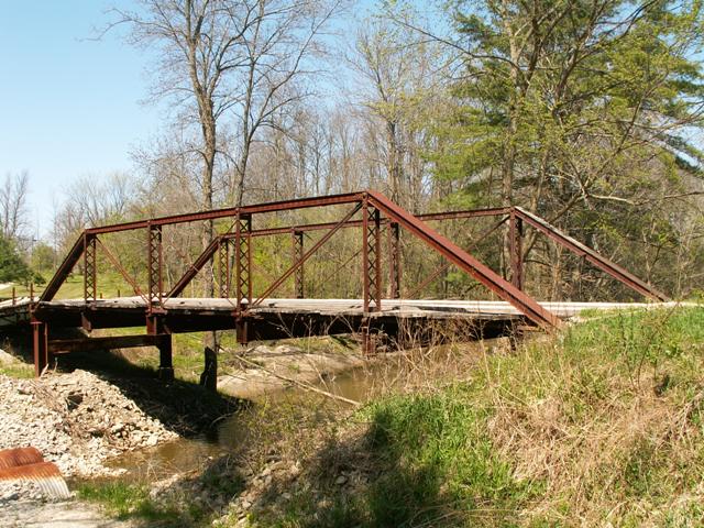
This bridge is a Pratt through truss, with five panels. Vertical members are latticed, and no v-lacing is present on the bridge. Floor beams are built-up. Originally located on Belle River Road near Capac, MI, this bridge was moved off the road some time ago to a nearby farm. Later, the bridge made another move to a private drive on Frith Road, where it remains today.
The date of construction is likely somewhere from the late 1880s through the 1890s. Based on two particular unusual details of the bridge: the design of the cast iron nuts for the connection pins, and what appears to be the remains of a missing top chord mounted builder plaque (only the base attachment to the top chord remains), this bridge was almost certainly built by the Groton Bridge Company of Groton, New York. The latticed verticals was also the preferred style for this bridge company.
The owner of this bridge undertook all the work on this bridge himself. Among other things, he built a wooden deck for the bridge. This deck is extremely well-done, and really makes this bridge feel historically correct. Have a look at the photo gallery for this bridge, and then compare it to Martin Road, which has a similar, but much older wooden deck. The owner also built home-made caissons and approaches for the bridge. The caissons were made by sinking metal barrels seven barrels deep into the ground, and then filling them with concrete. Although this bridge may not have originally been sitting on caissons, this method of concrete inside metal historically was a technique applied in period bridge construction, and is how the Frith Road Bridge and the Morseville Bridge are supported.
This bridge is tagged with the following special condition(s): Unorganized Photos
![]()
Photo Galleries and Videos: Frith Road Private Bridge
Bridge Photo-Documentation
A collection of overview and detail photos. This photo gallery contains a combination of Original Size photos and Mobile Optimized photos in a touch-friendly popup viewer.Alternatively, Browse Without Using Viewer
![]()
Additional Unorganized Photos
Original / Full Size PhotosThis photo gallery features older ca. 2003-2006 photos taken when the website only included a few photos in original size on the website, and a smaller quantity of reduced size photos as well. This unorganized gallery may partially duplicate photos in other galleries on this bridge's page, however all photos here are available in the Original / Full Size. This gallery offers photos in the highest available resolution and file size in a touch-friendly popup viewer.
Alternatively, Browse Without Using Viewer
![]()
Additional Unorganized Photos
Mobile Optimized PhotosThis photo gallery features older ca. 2003-2006 photos taken when the website only included a few photos in original size on the website, and a smaller quantity of reduced size photos as well. This unorganized gallery may partially duplicate photos in other galleries on this bridge's page, however all photos here are available in the Original / Full Size. This gallery features data-friendly, fast-loading photos in a touch-friendly popup viewer.
Alternatively, Browse Without Using Viewer
![]()
Maps and Links: Frith Road Private Bridge
Coordinates (Latitude, Longitude):
Search For Additional Bridge Listings:
Bridgehunter.com: View listed bridges within 0.5 miles (0.8 kilometers) of this bridge.
Bridgehunter.com: View listed bridges within 10 miles (16 kilometers) of this bridge.
Additional Maps:
Google Streetview (If Available)
GeoHack (Additional Links and Coordinates)
Apple Maps (Via DuckDuckGo Search)
Apple Maps (Apple devices only)
Android: Open Location In Your Map or GPS App
Flickr Gallery (Find Nearby Photos)
Wikimedia Commons (Find Nearby Photos)
Directions Via Sygic For Android
Directions Via Sygic For iOS and Android Dolphin Browser
USGS National Map (United States Only)
Historical USGS Topo Maps (United States Only)
Historic Aerials (United States Only)
CalTopo Maps (United States Only)

