

View Information About HSR Ratings
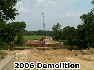
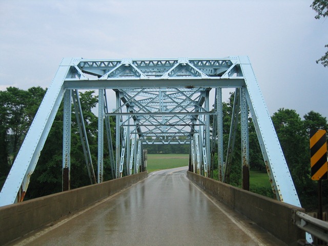
In 2006, many of Pennsylvania's surviving state standard truss bridges dated to the 1930s and even the 1940s. As a result, this bridge, constructed in 1928, was an early surviving example of a standardized state-built truss bridge in Pennsylvania. The bridge had a lighter weight portal bracing than found on later examples. The bridge was largely unaltered and had good historic integrity. The bridge likely could have been rehabilitated for less than the cost of demolishing and replacing it. This did not save this bridge however, since demolition and replacement was sadly the fate of this bridge.
Information and Findings From Pennsylvania's Historic Bridge InventoryDiscussion of Bridge The 1928, 2 span, 180'-long bridge consists of a 150'-long, riveted Parker thru truss main span and a 30'-long reinforced concrete T beam approach span. It is supported on concrete abutments and a concrete cutwater pier. The bridge, a late example of a common technology, has no innovative or distinctive details. Riveted truss bridges were used in Pennsylvania since ca. 1895 and were erected with great frequency by both county and state bridge builders in the 20th century. This bridge is one of approximately 90 riveted Parker truss bridges statewide dating from after 1925. The highway is not historically significant. Although now a part of US 6, at the time the bridge was built the highway was designated SR 79, a secondary road connecting Union City (Erie County) with the Pennsylvania-Ohio state line. It was redesignated US 6 following WW II. Neither the bridge nor its setting is technologically or historically significant. Discussion of Surrounding Area The bridge carries a 2 lane road over a stream near the intersection with US 19. The setting is predominantly rural and agricultural, with scattered commercial buildings, including one from the late 20th century at the southwest quadrant. The area lacks the cohesiveness and significance of a potential historic district. Bridge Considered Historic By Survey: No |
![]()
![]()
![]()
This historic bridge has been demolished. This map is shown for reference purposes only.
Coordinates (Latitude, Longitude):
Search For Additional Bridge Listings:
Bridgehunter.com: View listed bridges within 0.5 miles (0.8 kilometers) of this bridge.
Bridgehunter.com: View listed bridges within 10 miles (16 kilometers) of this bridge.
Additional Maps:
Google Streetview (If Available)
GeoHack (Additional Links and Coordinates)
Apple Maps (Via DuckDuckGo Search)
Apple Maps (Apple devices only)
Android: Open Location In Your Map or GPS App
Flickr Gallery (Find Nearby Photos)
Wikimedia Commons (Find Nearby Photos)
Directions Via Sygic For Android
Directions Via Sygic For iOS and Android Dolphin Browser
USGS National Map (United States Only)
Historical USGS Topo Maps (United States Only)
Historic Aerials (United States Only)
CalTopo Maps (United States Only)

© Copyright 2003-2026, HistoricBridges.org. All Rights Reserved. Disclaimer: HistoricBridges.org is a volunteer group of private citizens. HistoricBridges.org is NOT a government agency, does not represent or work with any governmental agencies, nor is it in any way associated with any government agency or any non-profit organization. While we strive for accuracy in our factual content, HistoricBridges.org offers no guarantee of accuracy. Information is provided "as is" without warranty of any kind, either expressed or implied. Information could include technical inaccuracies or errors of omission. Opinions and commentary are the opinions of the respective HistoricBridges.org member who made them and do not necessarily represent the views of anyone else, including any outside photographers whose images may appear on the page in which the commentary appears. HistoricBridges.org does not bear any responsibility for any consequences resulting from the use of this or any other HistoricBridges.org information. Owners and users of bridges have the responsibility of correctly following all applicable laws, rules, and regulations, regardless of any HistoricBridges.org information.
![]()