

View Information About HSR Ratings
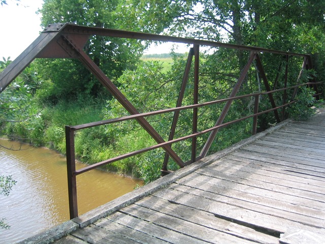
This bridge utilizes an uncommon lightweight truss design. When this bridge was built, it was a budget bridge, built as cheaply as possible, accounting for members that are more lightweight than most truss bridges of the period. Nevertheless, this bridge has managed to stand into the 21st Century. The bridge is closed to traffic and is not being maintained. Eventually this bridge may no longer be around. Sadly, the plaque that was once on this bridge has been stolen. Otherwise, this bridge retains good historic integrity, with a wooden deck and simple steel angle guardrails. The wooden posts that support the bridge at mid-span alter the historic integrity, but are a feature that could easily be corrected by removing them as part of a comprehensive restoration of this bridge.
MDOT's Historic Bridge Inventory incorrectly lists this bridge as being the Parker Road Bridge.
Information and Findings From Michigan Historic Bridge Inventory
Narrative Description This small-scale pony truss carries Parker Road over the Charlotte River
about 6.5 miles east of Dafter. The bridge is a 50-foot, three-panel,
rigid-connected Warren pony truss, with web members made up of
back-to-back pairs of steel angles. I-beam floor beams are field-bolted
to the verticals, and support the concrete deck. The webs are braced by
steel-angle outriders bolted to the verticals. The truss is carried by
concrete full-height abutments with angled wingwalls. The truss has more
recently been braced by building a timber pile pier at mid-span. This is
the only serious structural alteration it has undergone. Statement of Significance Two-angle trusses were fabricated with both Pratt and Warren web configurations, invariably with rigid connections. The Parker Road Bridge in Chippewa County exemplifies this construction trend. A cast iron plate on its end post identifies its fabricator as the Minneapolis Bridge Company. Built in 1914, apparently for the Bruce Township Board, it is the only such two-angle truss in Michigan that has been definitively dated. As such it is distinguished as the best-documented representative of this relatively common pony truss subtype. |
This bridge is tagged with the following special condition(s): Available
![]()
![]()
![]()
Coordinates (Latitude, Longitude):
Search For Additional Bridge Listings:
Bridgehunter.com: View listed bridges within 0.5 miles (0.8 kilometers) of this bridge.
Bridgehunter.com: View listed bridges within 10 miles (16 kilometers) of this bridge.
Additional Maps:
Google Streetview (If Available)
GeoHack (Additional Links and Coordinates)
Apple Maps (Via DuckDuckGo Search)
Apple Maps (Apple devices only)
Android: Open Location In Your Map or GPS App
Flickr Gallery (Find Nearby Photos)
Wikimedia Commons (Find Nearby Photos)
Directions Via Sygic For Android
Directions Via Sygic For iOS and Android Dolphin Browser
USGS National Map (United States Only)
Historical USGS Topo Maps (United States Only)
Historic Aerials (United States Only)
CalTopo Maps (United States Only)

© Copyright 2003-2024, HistoricBridges.org. All Rights Reserved. Disclaimer: HistoricBridges.org is a volunteer group of private citizens. HistoricBridges.org is NOT a government agency, does not represent or work with any governmental agencies, nor is it in any way associated with any government agency or any non-profit organization. While we strive for accuracy in our factual content, HistoricBridges.org offers no guarantee of accuracy. Information is provided "as is" without warranty of any kind, either expressed or implied. Information could include technical inaccuracies or errors of omission. Opinions and commentary are the opinions of the respective HistoricBridges.org member who made them and do not necessarily represent the views of anyone else, including any outside photographers whose images may appear on the page in which the commentary appears. HistoricBridges.org does not bear any responsibility for any consequences resulting from the use of this or any other HistoricBridges.org information. Owners and users of bridges have the responsibility of correctly following all applicable laws, rules, and regulations, regardless of any HistoricBridges.org information.
![]()
