

View Information About HSR Ratings
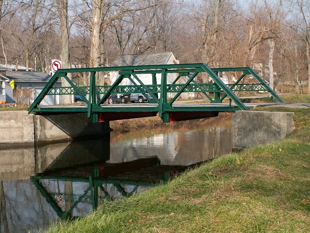
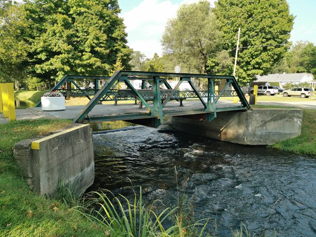
This bridge may be small, at only 28 feet in length, but it is nevertheless a very attractive bridge. According to the Michigan Historic Bridge Inventory the bridge was built in 1907. It is also locally significant as Kalamazoo County's last remaining truss bridge. It is also noteworthy as one of the only known examples of the Elkhart Bridge and Iron Company in Michigan. The bridge is a three panel Warren pony truss with riveted connections. The deck is concrete and has a jack-arch design, which was a common deck type when this was built. V-lacing is present under the top chord. There are outriggers on the bridge. Original lattice hub-guard style railings remain on the bridge. The only noticeable alteration was small steel supports wedged in between the bottom chord and the end post very close to the bottom of the endpost. Plaques used to be on the bridge, but have been stolen or vandalized. The corners of one of the two plaques that once were on the bridge are still visible. The bridge was open to traffic and is posted at a three-ton weight limit, but has since been closed to vehicular traffic and is today preserved for pedestrian use. The bridge has been repainted since the visit visit by HistoricBridges.org. In its preserved state, benches have been put on the deck, and interpretive signage installed next to the bridge informing visitor's of this historic bridge's significance.
This bridge is tagged with the following special condition(s): Unorganized Photos
![]()
![]()
![]()
![]()
Coordinates (Latitude, Longitude):
Search For Additional Bridge Listings:
Bridgehunter.com: View listed bridges within 0.5 miles (0.8 kilometers) of this bridge.
Bridgehunter.com: View listed bridges within 10 miles (16 kilometers) of this bridge.
Additional Maps:
Google Streetview (If Available)
GeoHack (Additional Links and Coordinates)
Apple Maps (Via DuckDuckGo Search)
Apple Maps (Apple devices only)
Android: Open Location In Your Map or GPS App
Flickr Gallery (Find Nearby Photos)
Wikimedia Commons (Find Nearby Photos)
Directions Via Sygic For Android
Directions Via Sygic For iOS and Android Dolphin Browser
USGS National Map (United States Only)
Historical USGS Topo Maps (United States Only)
Historic Aerials (United States Only)
CalTopo Maps (United States Only)

© Copyright 2003-2024, HistoricBridges.org. All Rights Reserved. Disclaimer: HistoricBridges.org is a volunteer group of private citizens. HistoricBridges.org is NOT a government agency, does not represent or work with any governmental agencies, nor is it in any way associated with any government agency or any non-profit organization. While we strive for accuracy in our factual content, HistoricBridges.org offers no guarantee of accuracy. Information is provided "as is" without warranty of any kind, either expressed or implied. Information could include technical inaccuracies or errors of omission. Opinions and commentary are the opinions of the respective HistoricBridges.org member who made them and do not necessarily represent the views of anyone else, including any outside photographers whose images may appear on the page in which the commentary appears. HistoricBridges.org does not bear any responsibility for any consequences resulting from the use of this or any other HistoricBridges.org information. Owners and users of bridges have the responsibility of correctly following all applicable laws, rules, and regulations, regardless of any HistoricBridges.org information.
![]()