We Recommend:
Bach Steel - Experts at historic truss bridge restoration.
Cole Road Bridge

Primary Photographer(s): Nathan Holth
Bridge Documented: 2005 - October 17, 2021
Rural: Lenawee County, Michigan: United States
Not Available or Not Applicable
38.7 Feet (11.8 Meters)
40.0 Feet (12.2 Meters)
16 Feet (4.88 Meters)
1 Main Span(s)
46318H00008B010

View Information About HSR Ratings
Bridge Documentation
This bridge has been altered, resulting in a severe loss of historic integrity and significance!
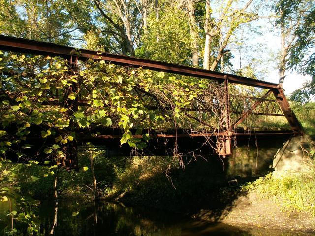
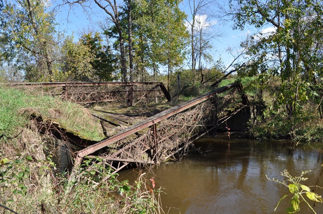
Bridge Status: This bridge has partially collapsed but as of 2021 the trusses remain on-site.This bridge is a half-hip pratt pony truss with pinned connections. The bridge has three panels. It sits on stone abutments, which are falling apart. V-lacing is present on vertical members. Lattice guardrails are present on the bridge. The deck is wood. Michigan Historic Bridge Inventory gave an 1897 construction date, and a 39 foot span length.
This bridge is at risk for collapse. First, the south truss has dropped a half foot because the stone abutment at that spot of falling away. Second, you can wiggle this southern truss with little effort. Despite this condition, the bridge remains a charming little treasure hidden away and overgrown on a closed road. It is a pity that this bridge was never relocated and preserved, perhaps as a trail bridge for pedestrians somewhere. By 2021, one of the trusses had indeed collapsed at one end, but the trusses remained on site and have not been removed.
The floor beams are in good condition overall, but evidence of heavy section loss and pack rust can be seen all over. Pack rust has broken the splice plate on the tops of the endposts off, and that classic ribbed appearance that the top chord cover plate gets when it is badly rusted is highly evident on this bridge. The condition of the bridge is quite a contrast to the much better looking Raymond Road Bridge which is a mere half mile north of this bridge.
View Archived National Bridge Inventory Report - Has Additional Details and Evaluation

Above: Bridge partially collapsed as seen in 2021. Photo Credit: Ron and Jakob Fricke
This bridge is tagged with the following special condition(s): Available and Unorganized Photos
![]()
Photo Galleries and Videos: Cole Road Bridge
Bridge Photo-Documentation
A collection of overview and detail photos. This photo gallery contains a combination of Original Size photos and Mobile Optimized photos in a touch-friendly popup viewer.Alternatively, Browse Without Using Viewer
![]()
Additional Unorganized Photos
Original / Full Size PhotosA supplemental collection of photos that are from additional visit(s) to the bridge and have not been organized or captioned. This gallery offers photos in the highest available resolution and file size in a touch-friendly popup viewer.
Alternatively, Browse Without Using Viewer
![]()
Additional Unorganized Photos
Mobile Optimized PhotosA supplemental collection of photos that are from additional visit(s) to the bridge and have not been organized or captioned. This gallery features data-friendly, fast-loading photos in a touch-friendly popup viewer.
Alternatively, Browse Without Using Viewer
![]()
Maps and Links: Cole Road Bridge
Coordinates (Latitude, Longitude):
Search For Additional Bridge Listings:
Bridgehunter.com: View listed bridges within 0.5 miles (0.8 kilometers) of this bridge.
Bridgehunter.com: View listed bridges within 10 miles (16 kilometers) of this bridge.
Additional Maps:
Google Streetview (If Available)
GeoHack (Additional Links and Coordinates)
Apple Maps (Via DuckDuckGo Search)
Apple Maps (Apple devices only)
Android: Open Location In Your Map or GPS App
Flickr Gallery (Find Nearby Photos)
Wikimedia Commons (Find Nearby Photos)
Directions Via Sygic For Android
Directions Via Sygic For iOS and Android Dolphin Browser
USGS National Map (United States Only)
Historical USGS Topo Maps (United States Only)
Historic Aerials (United States Only)
CalTopo Maps (United States Only)

