


View Information About HSR Ratings
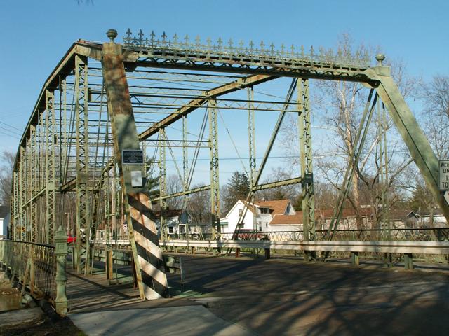
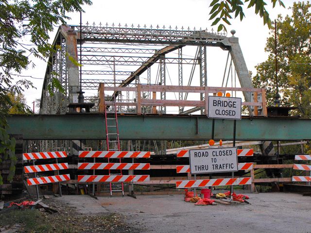
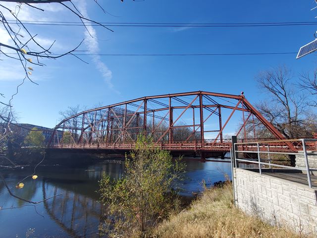
This bridge is inarguably the most beautiful and impressive bridge in all of Elkhart county, and probably beyond. It showcases everything that makes a truss bridge spectacular, and is well worth a visit. It certainly is the crown jewel of the city of Goshen. The Indiana Avenue bridge received a 1986 restoration, and again in 2010-2011. The 2010-2011 restoration was carefully executed so as to be respectful to the historic integrity of the bridge.
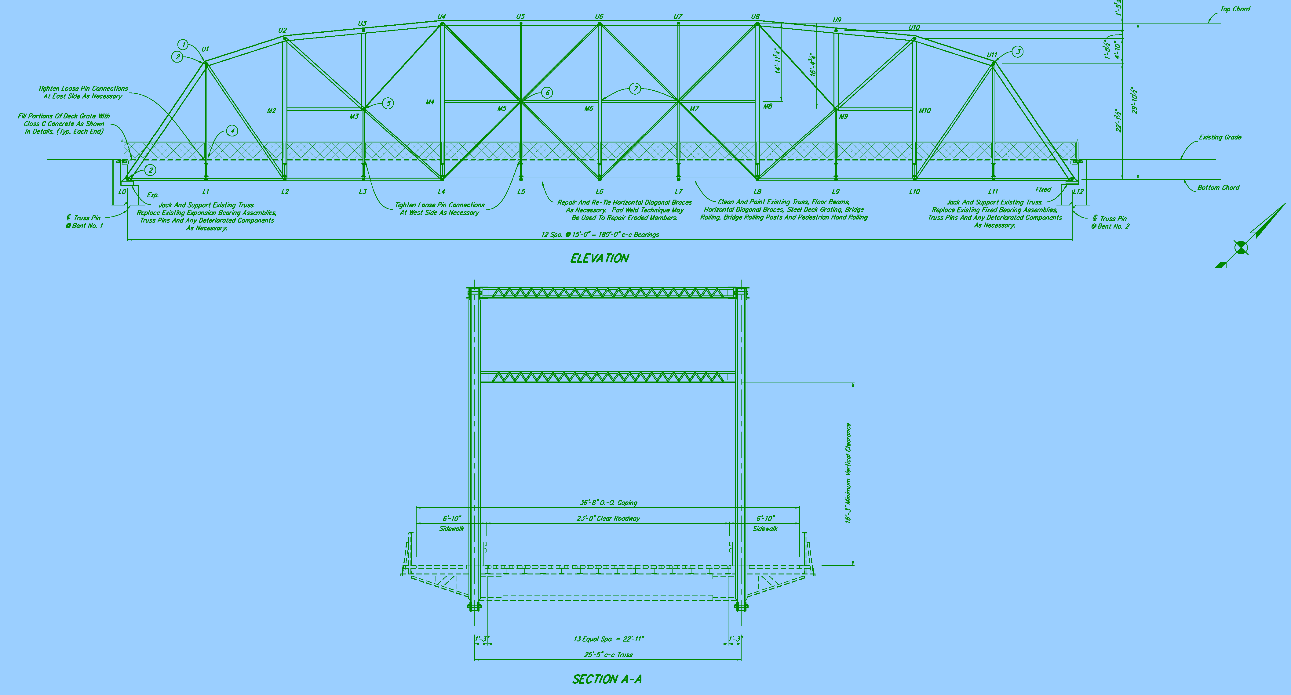
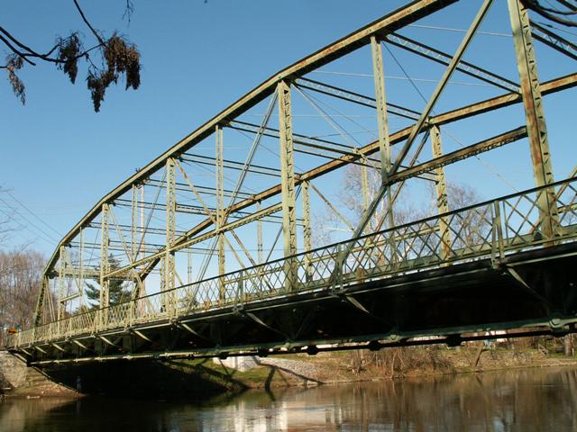
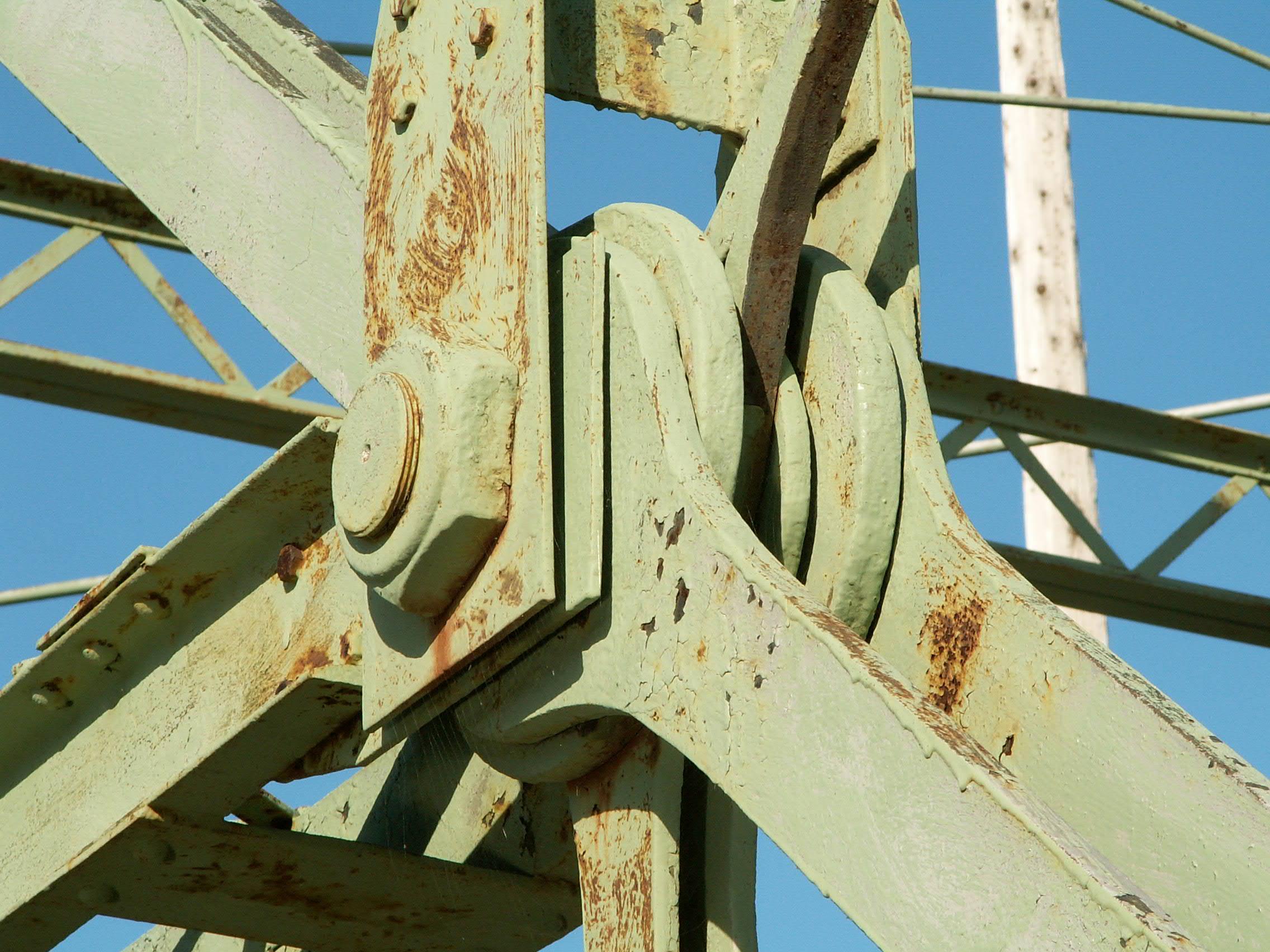
This bridge is a through truss bridge, specifically a Pennsylvania truss bridge. It was built in 1898. This special modification of the Pratt through design features the Parker shape as well as additional members added beyond the Pratt design. This particular bridge features an a top chord that runs horizontal longer than usual, giving the bridge a somewhat unusual appearance. Connections on the bridge are pinned. The bridge is composed of twelve panels. Railings on the roadway portion of the bridge are not original. Original pedestrian guardrails remain however, in the form of lattice guardrails, which are supported by small outriggers. These lattice guardrails feature decorative flower rivets in the center. The end posts for these railings are quite decorative as well. The sidewalks on each side of the bridge are cantilevered, and have a concrete deck. They may have originally had a wooden deck. The roadway deck is steel grate, and may have also been wood originally. V-lacing is extensive on the bridge: on the sway bracing, vertical members, under the top chord, and also on the short horizontal members on the bridge. Eyebars that are present on the bridge are the up-set type. The bridge features ornate steel decorations on top of its portal bracing, as well as round finials on top of the end posts. The bridge is seated on cut stone abutments. The bridge has a posted weight limit of twelve tons for all vehicles.
This bridge has everything that makes a truss bridge great. It is old, with an 1898 construction date, and based on that alone is historic. The v-lacing and complex Pennsylvania configuration of this bridge make a complex geometric beauty that is repeated in no other bridge type. As if that were not enough, extensive ornate decorative treatments on the portal and railings add to the beauty. The through nature of the bridge makes the bridge large and noticeable, making the crossing of the river an exciting experience, more interesting than the rest of the roadway. The people in charge of this bridge made the right choice in preserving it in 1986. It is important that they continue to stand by that decision and maintain this bridge for future generations to enjoy. Few truss bridges are as beautiful as this bridge, and the fact that there are so few truss bridges in this area of Indiana make it even more important, from a regional perspective. Goshen is lucky to be blessed with such a unique structure.
This bridge was finally officially listed in the National Register of Historic Places on September 9, 2005, although it had been considered eligible for years prior to that.
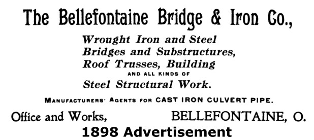
Information and Findings From DHPA Historic Bridge SurveyHistory of Bridge Fort Wayne Street was a link in the long-standing and important transportation route through Goshen between Elkhart to the northwest and Fort Wayne to the southeast. The Elkhart River had been spanned on Fort Wayne Street with a timber structure for some time. Although the wood was in decay, the impetus for a new bridge probably grew out of an agreement which the Elkhart County commissioners signed in June 1896 with the Indiana Electric Railway Company to construct a street railway on a county road from the village of New Paris north to and through Goshen. In August, the Goshen Common Council petitioned the county commissioners for a "new steel structure" of 175 ft. with a 24-ft. roadway with 5-ft. walks on each side designed with "ample strength to bear up heavy loads including street car travel and traffic." The commissioners inspected the old Fort Wayne Street Bridge and appointed E. W. Walker, Stephen T. Evans, and Charles Seibert, Sr. as viewers of the structure and site. The viewers found the existing "'pile structure'...rotten" and recommended the construction of a single metal-truss span seated upon cut-stone abutments raised a few feet higher than the timber bridge. The board of commissioners accepted the viewers report on August 25 and immediately contracted at $10,150 with the Bellefontaine Bridge and Iron Company of Bellefontaine, Ohio, for the stone substructure and steel superstructure. The commissioners agreed to the company's proposed "plans and detailed specifications" for the 180-ft. trusses with a 24-ft. roadway and a pair of 5-ft. walks. Bellefontaine received permission to use the old bridge for "putting up the trestle work...for convenience in erecting said iron bridge." Frank Brumbaugh--experienced as carpenter, machinist, bridge-shop foreman--had served as the Bellefontaine Bridge Company agent in Elkhart County for some time, and the commissioners had contracted with him before the big Fort Wayne Street contract came along. In time, Brumbaugh would leave his Ohio agency to establish the quite successful Elkhart Bridge & Iron Company (EB&ICo) to fabricate steel spans locally. EB&ICo became a major builder across Indiana, Michigan, Wisconsin and other points westward. Considerable as seemed the county board's confidence in Brumbaugh and Bellefontaine, commissioner Philip Nye moved in mid-October to name a construction inspector for the abutments of the Fort Wayne Street Bridge. The other two commissioners voted down Nye's motion, but the board as a whole began to make regular inspections of the construction site. On the third visit, they pronounced the work done to date as "satisfactory." In March 1897, the board formally inspected and accepted the "iron bridge" and paid Bellefontaine the contract price. Architectural Description The pinned Pennsylvania through-truss span with sub-ties extends 180 ft. subdivided into twelve panels. The four most central panels of the top chord are parallel with and 30-ft. away from the lower chord. The three panels which separate the top chord's center section from the endpost angle downward in two slopes to a truss depth of 22 ft. 3 in. at the portal. The top chords and endposts are fabricated from a pair of 12-in. channels riveted together with a cover plate and lacing bars. The lower chord consists of a pair of die-forged eyebars growing heavier toward midspan (from 7/8"x5" outer to 1.25"x7.25" inner). The hip verticals and the hangers on the lower half of the subdivided panels--every other vertical-- carry a pair of die-forged eyebars (9/16"x3"). The alternates consist mostly of a pair of laced 10- in. channels (except for 8-in. channels next to the hip vertical). A pair of die-forged eyebars supply each set of diagonals, with all inner ones being pinned at a horizontal strut. 1.13-in. adjustable square rods--pinned at the horizontal strut--counter the four center panels; the next panel beyond the center section is countered from the top chord to the horizontal strut. As is usual with Pennsylvania trusses, several devices help to stabilize the trusses. A pair of laced channels placed midway between the chords provide horizontal struts in the center section of panels where truss depth is greatest. The third panel in from each end also has a horizontal strut to stabilize web strains there. Braced-A struts made heavy to carry the electric power of the street railway originally reinforced the portals. Laced struts between upper panel points, reinforced with a lower strut on full-length verticals, plus adjustable rod lateral braces offered additional stiffening. Heavy rectangular girder floor-beams were riveted to angles in turn riveted to pin and vertical plates above the lower chord. Adjustable rod lower laterals braced the floor system. Brackets added outside the floor-beams carry the sidewalks. Rolled I-beams stringers assist the floor-beams in supporting the roadway--originally of timber, then of concrete, and now of steel grate. The original railings lining the trusses have been replaced with contemporary metal ones. The original additionally-decorated, latticed sidewalk rails remain. The portals retain their elaborate cresting and most of their celebratory finials. Other Information The product of a prolific Ohio firm whose agent would soon organize an important Indiana bridge-building firm, this structure served transportation of a long-used, important route across Elkhart County. It is also the oldest surviving Pennsylvania through-truss highway bridge of only one of two left on roads in Indiana. The old Fort Wayne Street Bridge retains most of its original truss members, although a number have been repaired. The floor-beams have been reinforced on a couple of occasions; the stringers, deck, and roadway railings replaced; the special portal bracing for the street railway removed. The intricate cresting, most of the finials, and the decorated lattice walkway railings all remain intact. Bridge Considered Historic By Survey: Yes |
![]()
![]()
![]()
![]()
![]()
![]()
![]()
![]()
![]()
![]()
Coordinates (Latitude, Longitude):
Search For Additional Bridge Listings:
Bridgehunter.com: View listed bridges within 0.5 miles (0.8 kilometers) of this bridge.
Bridgehunter.com: View listed bridges within 10 miles (16 kilometers) of this bridge.
Additional Maps:
Google Streetview (If Available)
GeoHack (Additional Links and Coordinates)
Apple Maps (Via DuckDuckGo Search)
Apple Maps (Apple devices only)
Android: Open Location In Your Map or GPS App
Flickr Gallery (Find Nearby Photos)
Wikimedia Commons (Find Nearby Photos)
Directions Via Sygic For Android
Directions Via Sygic For iOS and Android Dolphin Browser
USGS National Map (United States Only)
Historical USGS Topo Maps (United States Only)
Historic Aerials (United States Only)
CalTopo Maps (United States Only)

© Copyright 2003-2024, HistoricBridges.org. All Rights Reserved. Disclaimer: HistoricBridges.org is a volunteer group of private citizens. HistoricBridges.org is NOT a government agency, does not represent or work with any governmental agencies, nor is it in any way associated with any government agency or any non-profit organization. While we strive for accuracy in our factual content, HistoricBridges.org offers no guarantee of accuracy. Information is provided "as is" without warranty of any kind, either expressed or implied. Information could include technical inaccuracies or errors of omission. Opinions and commentary are the opinions of the respective HistoricBridges.org member who made them and do not necessarily represent the views of anyone else, including any outside photographers whose images may appear on the page in which the commentary appears. HistoricBridges.org does not bear any responsibility for any consequences resulting from the use of this or any other HistoricBridges.org information. Owners and users of bridges have the responsibility of correctly following all applicable laws, rules, and regulations, regardless of any HistoricBridges.org information.
![]()