

View Information About HSR Ratings
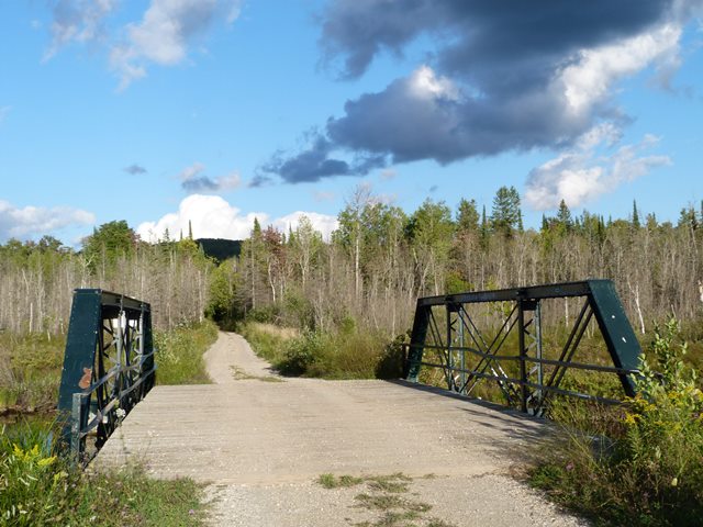
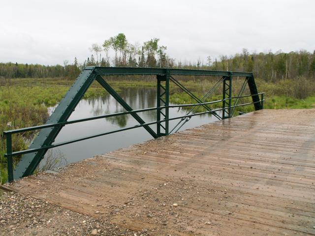
This bridge is a quaint three panel Pratt half-hip pony truss bridge with pinned connections. The bridge features v-lacing on the vertical members and under the top chord. It retains original simple angled steel railings. The deck was redone, and continues to be a wooden deck. Lackawanna stamps on present on the trusses.
Charlevoix chose to keep this beautiful historic bridge around and restored the bridge for continued vehicular traffic. Located on a trail-like road that is even more narrow than the narrow-one lane bridge, this structure is certainly sufficient for the road. The restoration of the bridge was excellent, as it did not alter the historic integrity of the bridge, even retaining the original pole railings. In a part of the state that has very few truss bridges, this bridge is an oasis of beauty and transportation heritage.
Note to photographers: This bridge is in what amounts to a swamp, and side views are essentially impossible. If you happen to have a canoe or kayak with you, then you would be in business!
This bridge is tagged with the following special condition(s): Unorganized Photos
![]()
![]()
![]()
![]()
Coordinates (Latitude, Longitude):
Search For Additional Bridge Listings:
Bridgehunter.com: View listed bridges within 0.5 miles (0.8 kilometers) of this bridge.
Bridgehunter.com: View listed bridges within 10 miles (16 kilometers) of this bridge.
Additional Maps:
Google Streetview (If Available)
GeoHack (Additional Links and Coordinates)
Apple Maps (Via DuckDuckGo Search)
Apple Maps (Apple devices only)
Android: Open Location In Your Map or GPS App
Flickr Gallery (Find Nearby Photos)
Wikimedia Commons (Find Nearby Photos)
Directions Via Sygic For Android
Directions Via Sygic For iOS and Android Dolphin Browser
USGS National Map (United States Only)
Historical USGS Topo Maps (United States Only)
Historic Aerials (United States Only)
CalTopo Maps (United States Only)

© Copyright 2003-2024, HistoricBridges.org. All Rights Reserved. Disclaimer: HistoricBridges.org is a volunteer group of private citizens. HistoricBridges.org is NOT a government agency, does not represent or work with any governmental agencies, nor is it in any way associated with any government agency or any non-profit organization. While we strive for accuracy in our factual content, HistoricBridges.org offers no guarantee of accuracy. Information is provided "as is" without warranty of any kind, either expressed or implied. Information could include technical inaccuracies or errors of omission. Opinions and commentary are the opinions of the respective HistoricBridges.org member who made them and do not necessarily represent the views of anyone else, including any outside photographers whose images may appear on the page in which the commentary appears. HistoricBridges.org does not bear any responsibility for any consequences resulting from the use of this or any other HistoricBridges.org information. Owners and users of bridges have the responsibility of correctly following all applicable laws, rules, and regulations, regardless of any HistoricBridges.org information.
![]()