

View Information About HSR Ratings
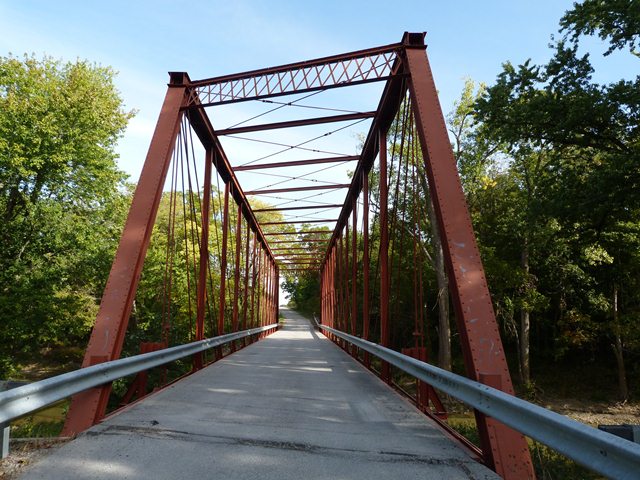
This bridge is significant on a statewide basis as an example of a Whipple through truss, and also as a skewed pin-connected truss bridge. Pin-connected truss bridges do not often have a skew. The bridge is locally significant as the only remaining truss built by the in-county bridge builder, Western Bridge Works of Fort Wayne. This bridge features unusual turnbuckles that are only threaded at one end. Also, the rivets on the end post have unusually shaped heads on one end.
The bridge has been sensitively rehabilitated and it retains good historic integrity and good structural integrity.
Despite there being more Whipple trusses in Allen County (as of early 2006) than are in the whole of the state of Michigan, Whipple trusses are a less common, and significant structure type. As a skewed structure (20% skew) the bridge is even more significant. The bridge is also significant as an early surviving metal truss bridge, completed ca. 1880.
Information and Findings From DHPA Historic Bridge SurveyStatement of Significance Allen County authorities selected noted local masons and an important local fabricator to build this bridge on an established public highway. The wrought iron superstructure may be the sole surviving example of the earliest Indiana metal-bridge fabricator. Whipple through-trusses are increasingly rare, and skewed ones are novel, indeed. The trusses retain their original members, including decoratively-latticed portals. Architectural Description Western Bridge separated the chords of this 175 ft., pin-connected, double-intersection Pratt (Whipple) through-truss span by 24 ft., subdivided the trusses into fourteen panels, and offset one truss from the other by 20 degrees. Rods hang as hip verticals. The intermediate ones consist of a pair of channels riveted together with plates to make an I beam which, in turn, is riveted to pin plates above and below. A pair of die-forged eyebars serve as diagonals in each panel except the three most central ones where a pair of cylindrical rods with turnbuckles double as diagonals and counters. Latticed portal struts, intermediate struts attached to the top chord above the upper panel points, and adjustable-rod lateral braces help to stabilize the high trusses. The bridge maintains 20 feet and 10 inches of vehicular clearance above the roadway. U-bolted to pins, the I floor-beams support I-beam stringers which together carry 16-ft timber roadway. Twentieth-century metal rails line the trusses. Other Information Michael J. Ross and more than a hundred other living in Marion township petitioned the Allen County Board of Commissioners in November 1879 for a bridge over the St. Mary's River on this established north-south public highway through the center of the township. In December, the Board ordered the Auditor to advertise for bids for construction of the "Morton Bridge," named for the largest adjacent property owner. Five companies presented proposals for Howe trusses, other timber-iron combinations, and wrought iron designs. After the county's surveyor, William H. Goshorn, reported on the "strain sheets" which the companies had submitted, the Board accepted the lowest wrought iron proposal--that of Charles L. Olds, "doing business under the name of Western Bridge Works of Fort Wayne," who bid $39 per lineal foot or $6,825. William Moellering and Henry C. Paul won the contract for stone abutments. Bridge Considered Historic By Survey: Yes |
![]()
![]()
![]()

![]()
Coordinates (Latitude, Longitude):
Search For Additional Bridge Listings:
Bridgehunter.com: View listed bridges within 0.5 miles (0.8 kilometers) of this bridge.
Bridgehunter.com: View listed bridges within 10 miles (16 kilometers) of this bridge.
Additional Maps:
Google Streetview (If Available)
GeoHack (Additional Links and Coordinates)
Apple Maps (Via DuckDuckGo Search)
Apple Maps (Apple devices only)
Android: Open Location In Your Map or GPS App
Flickr Gallery (Find Nearby Photos)
Wikimedia Commons (Find Nearby Photos)
Directions Via Sygic For Android
Directions Via Sygic For iOS and Android Dolphin Browser
USGS National Map (United States Only)
Historical USGS Topo Maps (United States Only)
Historic Aerials (United States Only)
CalTopo Maps (United States Only)

© Copyright 2003-2024, HistoricBridges.org. All Rights Reserved. Disclaimer: HistoricBridges.org is a volunteer group of private citizens. HistoricBridges.org is NOT a government agency, does not represent or work with any governmental agencies, nor is it in any way associated with any government agency or any non-profit organization. While we strive for accuracy in our factual content, HistoricBridges.org offers no guarantee of accuracy. Information is provided "as is" without warranty of any kind, either expressed or implied. Information could include technical inaccuracies or errors of omission. Opinions and commentary are the opinions of the respective HistoricBridges.org member who made them and do not necessarily represent the views of anyone else, including any outside photographers whose images may appear on the page in which the commentary appears. HistoricBridges.org does not bear any responsibility for any consequences resulting from the use of this or any other HistoricBridges.org information. Owners and users of bridges have the responsibility of correctly following all applicable laws, rules, and regulations, regardless of any HistoricBridges.org information.
![]()