

View Information About HSR Ratings
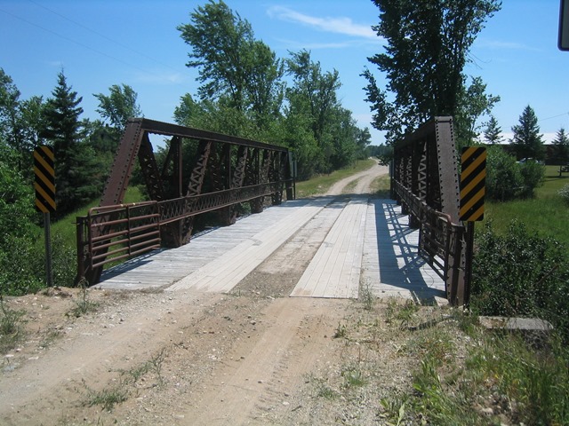
This fascinating bridge sits on a short road that nearly nobody uses. So few people use it, that the road leading to it is more like a two track trail. In 2005 the bridge had a fairly new wooden deck on it. That did not save this bridge from being demolished and replaced. Replacing this bridge was an enormous waste of tax dollars and an equally large waste of history. The one lane bridge was perfect for a quiet rural "road" that is more like a trail. The bridge was in need of rehabilitation, but was not so deteriorated that rehabilitation would have been overly difficult or costly. The bridge was a significant historic bridge, as one of the first state trunk line bridges built in Michigan.
The Rutledge Road Bridge is among a handsome, well-proportioned example of a pony truss. The bridge is a Warren pony truss with riveted connections, and it sits on concrete abutments. Outriggers are present at the vertical members. The steel on the bridge was fabricated by the Cambria Steel Company. Original lattice railing remains on the bridge, and v-lacing is present on all diagonals, as well as under the top chord. A small portion of the lattice railing has been replaced by a section of metal that looks like someone took a little time to make look halfway like the lattice. The lattice and v-lacing add to the geometric beauty of the bridge.
The members on this bridge are a bit more massive than most Michigan pony trusses. The plaque on the bridge lends some insight as to why this is so. The bridge is listed as a State Trunkline Bridge, which means it would have been made more bulky than a rural truss bridge, since it would be carrying the heavier trunkline traffic. Since the construction date of this bridge is 1914, this bridge was built in the first year of the state trunkline system's existence! It is not the first however; that credit goes to a concrete girder in Marquette County. Rutledge Road Bridge is on a road that basically goes nowhere, and nothing indicates that this road was ever part of a state trunkline. As such, that seems to indicate that this bridge is not in its original location. This bridge may have been on a trunkline elsewhere, and when the bridge became insufficient for the road it was on, it was given or sold to Mackinac county, who used it for this rural crossing.
This bridge is significant as a former trunkline truss bridge, built in the first year of the state trunkline system's creation. It was likely built to a standard plan developed by the State Highway Department, although today it would be hard to tell due to lack of other similar bridges remaining. Also, as MDOT's website mentions, the bridge was built by Central State Bridge Co. of Indianapolis, and it is the last example of this company's work in Michigan. Its outstanding historic integrity also makes it an important structure. Plentiful v-lacing also makes this a beautiful bridge.
Information and Findings From Michigan Historic Bridge InventoryNarrative Description This bridge is the only known surviving example of a pony truss bridge built in Michigan by the Central State Bridge Company of Indianapolis, Indiana. With a main span of 81 feet, it is also among the longest known surviving Warren pony truss bridges in Michigan, since only fifteen percent of the total exceed eighty feet. |
![]()
![]()
![]()
This historic bridge has been demolished. This map is shown for reference purposes only.
Coordinates (Latitude, Longitude):
Search For Additional Bridge Listings:
Bridgehunter.com: View listed bridges within 0.5 miles (0.8 kilometers) of this bridge.
Bridgehunter.com: View listed bridges within 10 miles (16 kilometers) of this bridge.
Additional Maps:
Google Streetview (If Available)
GeoHack (Additional Links and Coordinates)
Apple Maps (Via DuckDuckGo Search)
Apple Maps (Apple devices only)
Android: Open Location In Your Map or GPS App
Flickr Gallery (Find Nearby Photos)
Wikimedia Commons (Find Nearby Photos)
Directions Via Sygic For Android
Directions Via Sygic For iOS and Android Dolphin Browser
USGS National Map (United States Only)
Historical USGS Topo Maps (United States Only)
Historic Aerials (United States Only)
CalTopo Maps (United States Only)

© Copyright 2003-2025, HistoricBridges.org. All Rights Reserved. Disclaimer: HistoricBridges.org is a volunteer group of private citizens. HistoricBridges.org is NOT a government agency, does not represent or work with any governmental agencies, nor is it in any way associated with any government agency or any non-profit organization. While we strive for accuracy in our factual content, HistoricBridges.org offers no guarantee of accuracy. Information is provided "as is" without warranty of any kind, either expressed or implied. Information could include technical inaccuracies or errors of omission. Opinions and commentary are the opinions of the respective HistoricBridges.org member who made them and do not necessarily represent the views of anyone else, including any outside photographers whose images may appear on the page in which the commentary appears. HistoricBridges.org does not bear any responsibility for any consequences resulting from the use of this or any other HistoricBridges.org information. Owners and users of bridges have the responsibility of correctly following all applicable laws, rules, and regulations, regardless of any HistoricBridges.org information.
![]()