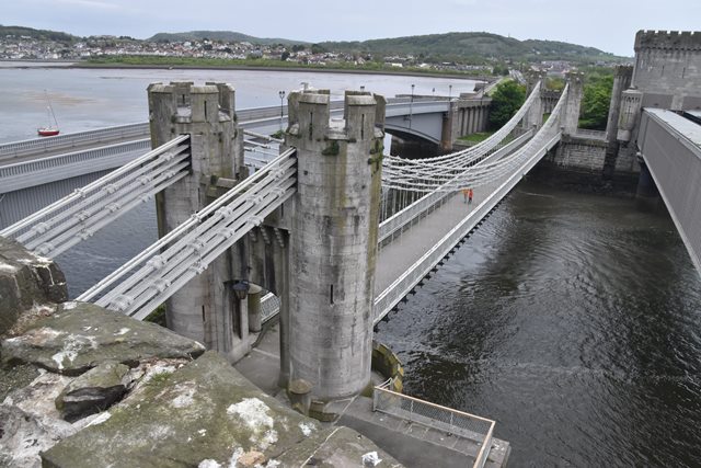
Not only is this suspension bridge noted for retaining its original eyebar
chains, its setting is unique next to Castle Conwy and two other historic
bridges: the
Conwy Railway Bridge, and the
Conwy Road Bridge. Beautiful views of all three bridges can be had from Castle Conwy.
Indeed this bridge is unique as its backstay chains pass through the walls to
the inside of Castle Conwy, with the anchorages at that end of the bridge
concealed within the castle.
The fact that this bridge retains its original eyebar chains sets it apart
from other bridges such as the Menai Bridge. Newer cables were added above the
original eyebar chains, however the chains appear to be largely unaltered. Thus
this bridge illustrates very well the design of early suspension bridges. It is
also noted as a work by the famous engineer Thomas Telford.
The lattice railing on this bridge is not original, but is riveted with
bolted alterations. The railing also appears to provide a function as a
stiffening girder to some extent.
The architectural design of the bridge and toll-takers house were designed to
harmonize with Castle Conwy.
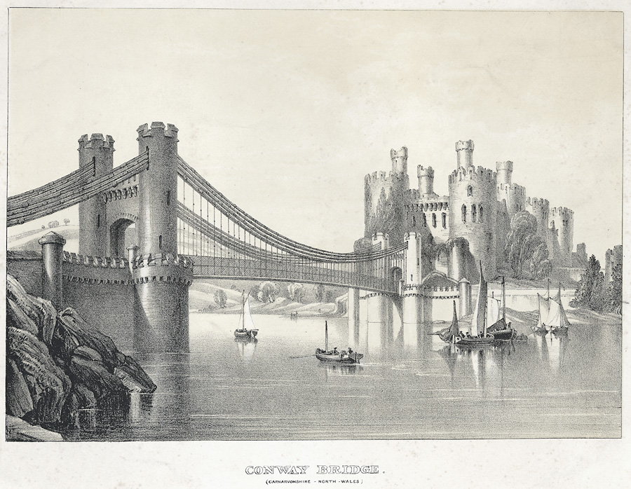
Above: Historical photo showing bridge ca. 1840. The railway bridge had not
yet been built at this time. Note that the railing/stiffening girders are
different than those seen today.
Official Heritage Listing Information and Findings
Listed At: Grade I
Discussion:
Reference Number: 3234
History In 1821
£41,000 of public money was made available for a bridge across the River
Conwy, part of the improvements to the route between Chester and
Holyhead. The bridge was begun in 1822 and was completed in 1826 at a
cost of £51,000. Its engineer was Thomas Telford, with William Provis
acting as site engineer. Its design, one of the earliest surviving
suspension bridges, closely resembles that of Telford's contemporary
Menai Bridge, but its castellated towers were intended to harmonise with
the castle, and in overall effect, the bridge resembles a giant
drawbridge. The original wood-block deck was replaced by an iron-plated
roadway in the late C19. In 1903 the bridge was strengthened by adding
wire cables above the original chains, and a footway 6-feet wide was
added on the N side in 1904. The bridge, however, retains its original
chains, probably from Upton in Shropshire, the forge of William
Hazeldine, the chief supplier of ironwork to Thomas Telford. The bridge
closed to traffic in 1958, when the adjacent Conway Bridge opened, and
since 1965 it has been owned by The National Trust. A new galvanised
balustrade was added in the last decade of the C20.
Exterior
A suspension bridge with castellated towers. Each is composed of a pair
of round turrets, with blind loops, spanning a segmental arch, and false
machicolations to an embattled parapet. The outer faces have rebuilt gas
lamps above the arches. The deck is suspended from 4 tiers of original
chains, with a 5th upper tier added later. On the E side these are
anchored to a freestone and concrete plinth. On the W side they are
anchored to the base of the castle E barbican and bedrock. The deck is
laid with tarmac and has a painted balustrade of diamond-lattice
ironwork. The turrets and abutments are of rock-faced stone below the
deck. On the N (seaward) side is a corbelled walkway around the turrets
at deck level, added in 1904. On the S (landward) side similar walkways
have been altered by providing access to viewing platforms, which are
integral with the main abutments. On the W (castle) side the abutments
curve out to round terminal piers with stepped conical caps at parapet
level. The parapet on each side has a round pier with conical cap next
to the main tower. On the NW side the parapet continues a short
distance, and has a gap infilled with wrought-iron diamond latticework
similar to the main bridge. The E abutment is similar. On the SE side
the wall is extended to abut to the later railway bridge. On the NE side
a retaining wall and parapet continue beyond the terminal pier. This
section incorporates 2 corbelled round piers with conical caps, spanned
by diamond-lattice ironwork balustrade. Abutting the N side of the
bridge are low river walls integral with the Conway Bridge of 1958.
Photo Galleries and Videos: Conwy Suspension Bridge (Pont Grog Conwy)
Original / Full Size Photos A collection of overview and detail photos. This gallery offers photos in the highest available resolution and file size in a touch-friendly popup viewer. Alternatively, Browse Without Using Viewer
Mobile Optimized Photos A collection of overview and detail photos. This gallery features data-friendly, fast-loading photos in a touch-friendly popup viewer. Alternatively, Browse Without Using Viewer
Maps and Links: Conwy Suspension Bridge (Pont Grog Conwy)