We Recommend:
Bach Steel - Experts at historic truss bridge restoration.
Conwy Road Bridge

Primary Photographer(s): Nathan Holth
Bridge Documented: May 12, 2018
Conwy: Conwy, Wales (Cymru): United Kingdom
1958 By Builder/Contractor: Sir William Arrol and Company of Glasgow, Scotland and Engineer/Design: Herbert Walter Fitzsimons
Not Available or Not Applicable
325.0 Feet (99.1 Meters)
Not Available
23 Feet (7.01 Meters)
1 Main Span(s)
Not Applicable

View Information About HSR Ratings
Bridge Documentation
This location is truly unique, featuring three bridges: the Conwy Railway Bridge, the Conwy Suspension Bridge, and the Conwy Road Bridge, all located in the shadow of the beautiful Castle Conwy.
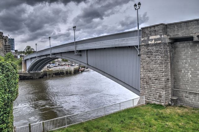
This riveted steel deck arch bridge is the youngest of three bridges at this location next to Castle Conwy. Although (in comparison to the castle and the other two bridges) this bridge is not very old having been built in 1958, it is of riveted construction and offers a nice comparison to the nearby older bridges, and because it is an arch bridge, it makes for a unique setting where three bridges next to each other crossing the same waterway each have a drastically different structure type.
An unusual feature of this bridge is that the spandrel wall is covered by a non-structural facade that hides the underlying structure. This facade appears to have been designed to harmonize with the visual appearance of the Conwy Railway Bridge, as it is a simple steel facing with vertical ribs, reminiscent of the appearance of the Railway Bridge's girder web.
Official Heritage Listing Information and FindingsListed At: Not Grade Listed Discussion: NPRN Number: 85483 Site Description Single-arched steel road bridge of 1958 carrying the
former A55 trunk road (nprn 403728) over the Afon Conwy; faced with
stone on the north side to harmonise with nearby Conwy Castle (nprn
121). The bridge was constructed to supersede Telford's adjacent
suspension bridge of 1826 (nprn 43083) and has itself been superseded by
a road tunnel (nprn 409064) under the estuary opened in 1991. |
![]()
Photo Galleries and Videos: Conwy Road Bridge
Bridge Photo-Documentation
Original / Full Size PhotosA collection of overview and detail photos. This gallery offers photos in the highest available resolution and file size in a touch-friendly popup viewer.
Alternatively, Browse Without Using Viewer
![]()
Bridge Photo-Documentation
Mobile Optimized PhotosA collection of overview and detail photos. This gallery features data-friendly, fast-loading photos in a touch-friendly popup viewer.
Alternatively, Browse Without Using Viewer
![]()
Maps and Links: Conwy Road Bridge
Coordinates (Latitude, Longitude):
Search For Additional Bridge Listings:
Additional Maps:
Google Streetview (If Available)
GeoHack (Additional Links and Coordinates)
Apple Maps (Via DuckDuckGo Search)
Apple Maps (Apple devices only)
Android: Open Location In Your Map or GPS App
Flickr Gallery (Find Nearby Photos)
Wikimedia Commons (Find Nearby Photos)
Directions Via Sygic For Android
Directions Via Sygic For iOS and Android Dolphin Browser
Ordnance Survey Maps (UK Only)

