HistoricBridges.org Menu: HistoricBridges.org Menu:


We Recommend:
Bach Steel - Experts at historic truss bridge restoration.

HistoricBridges.org: Bridge Browser

Sydney Gardens Bridge

Sydney Gardens Bridge

Primary Photographer(s): Bob Dover

Bridge Documented: December 1, 2014

View Photos
and Videos
View Maps
and Links

Facility Carried / Feature Intersected
Pedestrian Walkway Over Kennet and Avon Canal
Location
Bath: South West, England: United Kingdom
Construction Date and Builder / Engineer
1800 By Builder/Contractor: Coalbrookdale Company of Coalbrookdale, Shropshire, England
Rehabilitation Date
Not Available or Not Applicable
Main Span Length
Not Available
Structure Length
Not Available
Roadway Width
Not Available
Spans
1 Main Span(s)
Inventory Number
Not Applicable

Historic Significance Rating (HSR)
View Information About HSR Ratings

Bridge Documentation

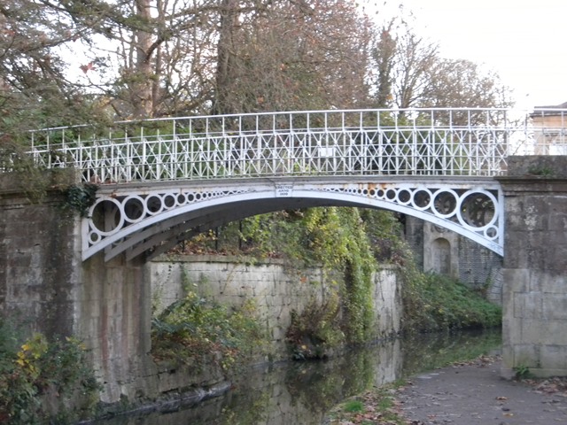
This is a very old example of a cast iron arch bridge and was cast by the famous Coalbrookdale Company.

Bob Dover provided the following information:

This is a tiny cast iron arch footbridge over a canal in a city park, which is not located very close to the tourist center of Bath.  You would be unlikely, as a tourist, to come across this bridge on your own, and even experienced seekers of historic bridges will have to do some work to find it.  But it is worth it, as it has a delightfully quirky design of graduated circles forming its arch.  It also proudly display its construction date on a plaque above the arch, reading “Erected Anno 1800”.  It is just a few steps from a similar cast iron bridge which has a similar “Erected Anno 1800” plaque on it.  This one is of different construction, and is not nearly as ornate.

Official Heritage Listing Information and Findings

Listed At: Grade II*

Discussion:

List Entry Number: 1395952

A footbridge over the Kennet and Avon Canal, dated 1800, designed by John Rennie, engineer, and manufactured by the Coalbrookdale factory at Ironbridge. MATERIALS: The structure is of cast iron, set on coped ashlar abutments. PLAN: The bridge is a single span measuring c.12m, with a width of c.6.5m, and is set on a pronounced skew of around 45 degrees. EXTERIOR: The bridge is formed from seven segmental arches with panelled intrados, and a cornice which forms the plinth to the balustrade above; the balustrade is formed from separate, vertical trellised panels which support the continuous handrail. At the vertex of the arch is a cast iron date plaque inscribed 'ERECTED / ANNO / 1800'. HISTORY: Sydney Gardens were laid out as commercial pleasure grounds between 1792 and 1794; the initial design was by the architect Thomas Baldwin, who, after he went bankrupt, was replaced by Charles Harcourt Masters in 1794. They were opened on 11 May 1795 as Sydney Gardens Vauxhall, and rapidly became a popular place of entertainment, hosting public breakfasts, promenades and galas. The main building was the Sydney Tavern (now the Holburne of Menstrie Museum), which stood at the western end of the central walk, and housed tea and card rooms, a ballroom, coffee room and a public house. In 1799, a section of the Kennet and Avon Canal (authorised 1794; opened 1810) was cut through the gardens, with the addition of decorative bridges and tunnels, which added to the picturesque appeal of the pleasure grounds; these were insisted upon by the proprietors of Sydney Gardens as part of their agreement with the canal company, which was entered into in 1795. The canal company paid £2,100 and the cost of providing the bridges and tunnels as compensation for the intrusion into the gardens. During the early C19, additional features and structures were introduced, adding variety and surprise in accordance with landscape design principles of the period. From c.1839, a section of the Great Western Railway was constructed, cutting through the gardens. Later in the C19, further ornamental structures were introduced, but these were largely cleared away after World War Two. In 1891, when the original 99-year lease of the Gardens expired, the entire site, including the Tavern, by then in use as a college, was sold, with the intention of replacing the former Tavern with a large hotel, and remodelling the grounds. The plan was abandoned and in 1908, the site was purchased by Bath City Council; the gardens were opened to the public as a municipal park in 1913, while the Tavern was remodelled by Sir Reginald Blomfield into the Holburne of Menstrie Museum. The gardens remain in use as a public park. This bridge, which continues the main axis through the park over the Kennet and Avon canal, was constructed in 1800 and remains largely unaltered since then.

REASONS FOR DESIGNATION DECISION The bridge in Sydney Gardens is designated at Grade II*, for the following principal reasons: * The bridge is a good example of an iron bridge by the renowned Coalbrookdale Foundry at Ironbridge, and was the earliest use of a pioneering method of creating skewed crossings * It is an unusually elegant example of a canal bridge, designed specifically to be decorative as well as functional at the behest of the owners of Sydney Gardens * It forms part of an important group of four bridges and tunnels on the canal as it passes through Sydney Gardens, all of which are designated at Grade II*, and has group value with these and the other listed structures in the Gardens

Divider

Photo Galleries and Videos: Sydney Gardens Bridge


View Photo Gallery

Bridge Photo-Documentation

Original / Full Size Photos
A collection of overview and detail photos. This gallery offers photos in the highest available resolution and file size in a touch-friendly popup viewer.
Alternatively, Browse Without Using Viewer

Divider

View Photo Gallery

Bridge Photo-Documentation

Mobile Optimized Photos
A collection of overview and detail photos. This gallery features data-friendly, fast-loading photos in a touch-friendly popup viewer.
Alternatively, Browse Without Using Viewer

Divider

Maps and Links: Sydney Gardens Bridge

Coordinates (Latitude, Longitude):

Search For Additional Bridge Listings:

HistoricBridges.org Bridge Browser: View listed bridges within 0.5 miles (0.8 kilometers) of this bridge.

HistoricBridges.org Bridge Browser: View listed bridges within 10 miles (16 kilometers) of this bridge.

Additional Maps:

Google Maps

Google Streetview (If Available)

Bing Maps

OpenStreetMap

GeoHack (Additional Links and Coordinates)

Apple Maps (Via DuckDuckGo Search)

Apple Maps (Apple devices only)

MapQuest

HERE We Go Maps

ACME Mapper

Waze Map

Android: Open Location In Your Map or GPS App

Flickr Gallery (Find Nearby Photos)

Wikimedia Commons (Find Nearby Photos)

Directions Via Sygic For Android

Directions Via Sygic For iOS and Android Dolphin Browser

Ordnance Survey Maps (UK Only)


Divider
 
Home Top

Divider

About - Contact

© Copyright 2003-2024, HistoricBridges.org. All Rights Reserved. Disclaimer: HistoricBridges.org is a volunteer group of private citizens. HistoricBridges.org is NOT a government agency, does not represent or work with any governmental agencies, nor is it in any way associated with any government agency or any non-profit organization. While we strive for accuracy in our factual content, HistoricBridges.org offers no guarantee of accuracy. Information is provided "as is" without warranty of any kind, either expressed or implied. Information could include technical inaccuracies or errors of omission. Opinions and commentary are the opinions of the respective HistoricBridges.org member who made them and do not necessarily represent the views of anyone else, including any outside photographers whose images may appear on the page in which the commentary appears. HistoricBridges.org does not bear any responsibility for any consequences resulting from the use of this or any other HistoricBridges.org information. Owners and users of bridges have the responsibility of correctly following all applicable laws, rules, and regulations, regardless of any HistoricBridges.org information.

Admin Login

Divider