Location
Llanfairpwllgwyngyll (Llanfairpwllgwyngyllgogerychwyrndrobwllllantysiliogogogoch) and Bangor: Isle of Anglesey (Ynys Môn), Wales (Cymru) and Gwynedd, Wales (Cymru): United Kingdom
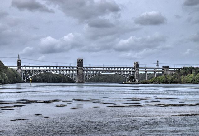
The Britannia Bridge as seen today is largely non-historic, since a
disastrous fire in 1970 destroyed the 1850 wrought iron tubular girders, and a
new steel deck arch superstructure had to be constructed. However, the original
1850 substructure, which is itself quite substantial, was reused, and for this
reason the bridge is listed on HistoricBridges.org. A section of the original
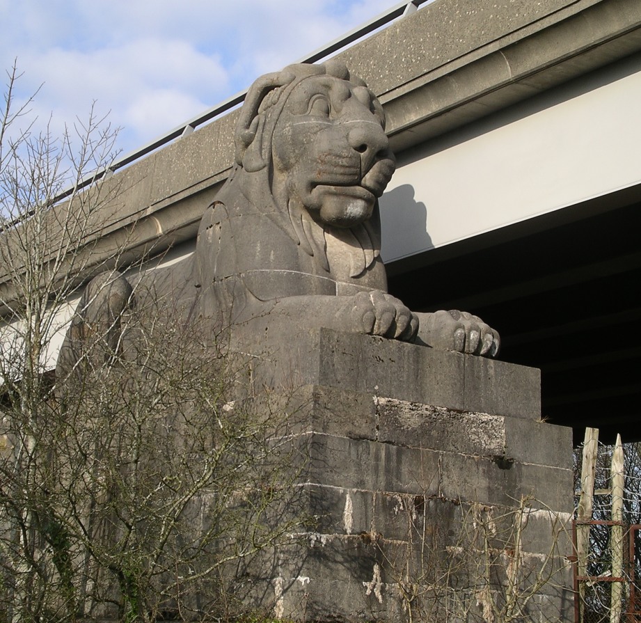
girder on display and the ornamental entrance lions also remain.
The original 1850 bridge was designed by Robert Stephenson and William
Fairbairn. Its design was similar to the
Conwy Railway Bridge,
which still exists today.
Above: Historical image showing the original bridge.
Above: Historical image showing the original bridge.
Above: View of a salvaged section of the original riveted tubular girder.
(Photo Credit: Wikipedia)
Above: View of one of the lion sculptures from the original 1850 bridge.
(Photo Credit: Wikipedia)
Official Heritage Listing Information and Findings
Listed At: Grade II
Discussion:
Reference Numbers: 3674 and 5488
History
Originally built as a railway bridge for the Chester and Holyhead
Railway, and designed by the renowned engineer-in-chief to the railway,
Robert Stephenson, in association with Francis Thompson, the railway's
architect, and Sir William Fairbairn as consultant engineer. The bridge
made novel use of a continuous tubular construction of iron plates,
forming twin tubes, set at the centre span 102ft ( 31m ) above the high
water line, each pair spanning 140m (459ft 3in) between the intermediate
water piers, the stonework built by Nowell Hemingway and Pearson, and
the whole scheme cost 674,000. Each of the two pairs of tubes carrying
the plateway, was 30ft high and 14ft 8in wide (9.1 x 4.45m), fixed at
the centre with rolling expansion joints in the Anglesey and Caernarvon
Towers. It was opened at a fine ceremony in 1850. The C & H Railway was
amalgamated with the London and North Western Railway in 1858. After a
serious fire on 23/5/1970, the bridge was extensively modified and
strengthened to provide a road carriageway above and in addition to the
rail track, designed by Husband & Co. for British Railways, using The
Cleveland Bridge & Engineering Co. Ltd. as contractors.
Exterior
The bridge piers are of rock-faced Anglesey limestone (Penmon Marble),
set on a plinth, and Runcorn sandstone and brickwork. Each of the 2
central water piers is 221ft 3in (67.5m) high from foundation on the sea
bedrock, and rise with battered sides to a corniced top raised on large
corner blocks forming voids, originally designed to take suspension
chains over rockers, on each face, all in an Egyptian Pylon style. The
piers are voided, and stone lintels 20ft (6m)long span the rectangular
holes for the twin tubes, with bold plat bands at the level of the top
and bottom of the tubes. Each side face carries a symbolic engineering
motif based on linked driving rods. The outer spans spring to similar
abutment towers, flanked by sculptured lions on high plinths (q.v.). A
huge figure of Britannia designed by Thompson for the centre pier was
never executed. Inscribed on the approach face to the mainland water
pier 'Erected Anno Domini MDCCCL Robert Stephenson Engineer'. The
modified bridge, opened on 11/6/1980, consists of braced rivetted steel
section arches with 'N'-truss spandrels spanning between the earlier
piers, with the roadway carried on stanchions above the railway. The
side spans are in reinforced concrete.
Lions:
History
One of four, one pair located on the mainland and one on the Anglesey
side, flanking each entrance to the bridge. Designed by the Victorian
sculptor John Thomas, who designed carvings for the new Houses of
Parliament (1835-52), and erected prior to the opening of the bridge in
1850. Each lion cost 1,024.
Exterior Large sculpture of a
lion couchant,25ft 6in (7.77m) long and 12ft 8in (3.86m) high; carved in
a bold Egyptian style and built from 11 pieces of Penmon limestone.
Facing S, the lion surmounts an ashlar limestone plinth which in turn
surmounts a plinth of rock-faced sandstone.
Original / Full Size Photos A collection of overview and detail photos. This gallery offers photos in the highest available resolution and file size in a touch-friendly popup viewer. Alternatively, Browse Without Using Viewer
Mobile Optimized Photos A collection of overview and detail photos. This gallery features data-friendly, fast-loading photos in a touch-friendly popup viewer. Alternatively, Browse Without Using Viewer