HistoricBridges.org Menu: HistoricBridges.org Menu:


We Recommend:
Bach Steel - Experts at historic truss bridge restoration.

HistoricBridges.org: Bridge Browser

Iron Bridge

Iron Bridge

Primary Photographer(s): Nathan Holth

Bridge Documented: December 2, 2014 and May 11, 2018

View Photos
and Videos
View Maps
and Links

Facility Carried / Feature Intersected
Pedestrian Walkway Over River Severn
Location
Coalbrookdale: West Midlands, England: United Kingdom
Structure Type
Metal (Cast Iron) Hingeless Deck Arch, Fixed and Approach Spans: Metal Hingeless Deck Arch,
Construction Date and Builder / Engineer
1779 By Builder/Contractor: Abraham Darby and Coalbrookdale Company of Coalbrookdale, Shropshire, England and Engineer/Design: Thomas Farnolls Pritchard
Rehabilitation Date
2018
Main Span Length
100.5 Feet (30.6 Meters)
Structure Length
Not Available
Roadway Width
Not Available
Spans
1 Main Span(s) and 3 Approach Span(s)
Inventory Number
Not Applicable

Historic Significance Rating (HSR)
View Information About HSR Ratings

Bridge Documentation

HistoricBridges.org covers many types of historic bridges, but metal bridges have always been at the forefront of the coverage. The Iron Bridge, so named because it was the very first iron bridge, is where the history of metal bridges begins. The Iron Bridge is one of the most important historic bridges in the world and on HistoricBridges.org. It is the first example of a bridge built using what became (and remains) one of the two primary materials from which bridges are built (iron/steel and concrete).

Since iron bridges had not been built before, techniques used to build timber bridges guided the design of the Iron Bridge. Once this timber-inspired design was proven successful, engineers went on to refine the design of future iron bridges to better make use of the unique properties of iron which were not possible with timber. Because of the timber-inspired design, and because this was truly an experimental prototype bridge, the Iron Bridge visually looks vastly different from other surviving cast iron arch bridges in the United Kingdom. Visitors to the Iron Bridge should consider also visiting the nearby Coalport Bridge, which is also one of the oldest iron bridges in the UK, as as well as the nearby Albert Edward Bridge. These two bridges offer a good comparison. The Coalport Bridge, like the Iron Bridge, was still built in an experimental period and it has an appearance that is reminiscent of the Iron Bridge, yet it has a much more lightweight appearance to it, suggesting engineers were becoming more confident using iron as a bridge building material. However, perhaps they were too overconfident. The bridge was built in 1799 with three arch ribs, but by 1818 two arch ribs had to be added to strengthen the bridge after cracking was discovered. In contrast, the Albert Edward Bridge, built in 1864, represents the typical appearance and design of a cast iron bridge after the period of experimentation was over, and the use of cast iron was well established. Note that the Albert Bridge has a more shallow arch, and the castings are much larger, and simpler in design.

In 2018, the Iron Bridge was visited by HistoricBridges.org, however this was during a massive restoration of this historic bridge. Thus, no photos of the iron superstructure from 2018 are available since the structure was enclosed in containment for painting. It is hard to be angry about this, since the preservation work being undertaken is of paramount importance to ensure that this historic bridge remains in good condition for centuries to come. To make up for the lack of photos in 2018, HistoricBridges.org is proud to offer a detail-focused collection of photos kindly provided by Bob Dover. These photos, taken in 2014, detail the design of the bridge prior to the 2018 preservation work. Visitors to the Iron Bridge today (with restoration complete) may find Bob's photos of interest as a point of comparison to see how the preservation work addressed the structural problems that existed on the bridge. Some of the problems, many of which dated to the earliest years of the bridge, included large cracks in the iron. While these cracks may look alarming, this bridge was substantially overbuilt, which is why it was able to stand even with these apparent problems.

In addition to the large, single main cast iron arch span, there are 2 small cast iron arch spans. These spans are much simpler in design compared to the main span. There is also a single stone arch approach span.

The Iron Bridge, and the surrounding area, is a UNESCO World Heritage Site.

Graces Guide has additional information.

Official Heritage Listing Information and Findings

Listed At: Grade I

Discussion:

List Entry Number: 1038659 (Listed Building and 1015325 (Scheduled Monument)

1778. The first bridge of cold-blast iron; cast at Coalbrookdale to the designs of Abraham Darby III. Now restricted to footbridge. Roadway rises on both sides to central span of approximately 100ft. Semicircular arch, with two concentric arch-rings with filigree of connecting members; circle and ogee-arched panel in each spandrel. Two subsidiary arches on south bank. Thin iron parapet railings.

Reasons for Designation
Iron was used as one of the components of bridge construction for at least a thousand years before it was first used as the principal construction material in the Iron Bridge erected by Abraham Darby in 1779 over the Severn at Coalbrookdale. Despite its use of iron, however, the Iron Bridge simply copied existing construction techniques suited to timber, and therefore did not make maximum use of the new material's potential. The engineer Thomas Telford subsequently recognised that the lighter cast iron frames allowed the use of flatter angles and less substantial foundations, whilst still enabling single spans and avoiding the central piers which hindered navigation and caused instability by attracting water-scouring. The development of the single span cast iron bridge thus represented a turning point in British bridge design and engineering. All examples which retain significant original fabric are of national importance and will merit statutory protection.

The Iron Bridge is a fine example of a class of monument which is rare nationally, and is often seen as a symbol of the heyday of British bridge design, if not of the Industrial Era itself. The standing structure of the bridge increases our understanding of the casting and assembly methods employed during this pioneering age. Archaeological deposits will survive below ground relating to its construction, and to the modification of its abutments over time. An extensive written and pictorial archive records the conception, design, construction and modification of the bridge, as well as its impact on the wider infrastructure and industrial development of the area. This World Heritage Site is a prominent landmark, with easy public access.

Details
The monument includes the standing and buried remains of The Iron Bridge, an 18th century single span, cast iron bridge which links the steep sides of the Ironbridge Gorge across the River Severn, and is now at the heart of the settlement to which it gave its name.

The initial bridge design was drawn up by Thomas Pritchard, a Shrewsbury architect, who had suggested to the ironmaster John Wilkinson in 1773 that an iron bridge should be constructed across the river. In 1776 a petition to parliament for a new bridge was successful, however iron had only been used for strengthening timber or stone structures in the past, and it was several months before the plan to construct the world's first completely cast iron bridge was agreed. Work began in 1777, to a design evidently instigated by Pritchard's original, although he himself had died earlier that year. The chosen crossing point, previously the ferry crossing from Benthall to Madeley Wood, had the advantage of high approaches on both sides and relative stability, but its distance from existing turnpikes and the major ironworks pushed up the total cost of construction to over 6000 pounds. Part of this expense was borne by Abraham Darby himself, who remained in debt for the rest of his life. The iron for the bridge was cast by the Coalbrookdale Company, and construction was completed in 1779, using in all 300 tons of cast and wrought iron. The bridge was originally carried between two huge rubble- filled, ashlar faced, stone abutments. It had a wrought iron hand rail which continued along the edges of the northern abutment, while a post and chain rail ran along the sides of the southern abutment. However, episodes of subsidence and flooding caused the southern abutment to crack, and it was replaced in 1801 with two stone piers, with a wooden roadway and hand rail between them. The wooden structure was in turn replaced in the 1820s by the iron arches which stand today, and an iron hand rail replaced the wooden one. On the north side the original parapet walls and footings were taken down in 1782 to accommodate one of the many buildings which were erected to either side of the north abutment. Shortly after this the west wall was also removed, probably as part of the construction of the Tontine stables close to the bridge abutment. The Iron Bridge remained in full use for over 150 years, by carts, stage coaches, and then increasing amounts of vehicular traffic. Concerns about its stability in the 1920s nearly led to its replacement with a concrete structure further upriver. In 1934 the bridge was designated an Ancient Monument and closed to vehicular traffic. In the 1970s a concrete strut was built on the river bed beneath the bridge, to brace the abutments which had moved 0.48m towards each other by 1969, and this structure is included in the scheduling. The Iron Bridge is now in the care of the Secretary of State, is Listed Grade I, and is part of the Ironbridge World Heritage Site designated in 1987.

The bridge is constructed of cold blast iron, and spans 100 feet 6 inches (c.30m). The main structure is composed of five semicircular ribs, braced laterally to each other, and by a filigree of connecting members to two concentric inner part ribs. The two outer ribs are engraved with the words `This Bridge was cast at Coalbrook-Dale and erected in the year MDCCLXXIX'. The spandrels, between the curve of the arch and the abutments, contain iron circles and an ogee shaped frame, both features of Thomas Pritchard's other designs. The bridge has delicate wrought-iron hand rails with a central ornamental roundel to either side, which early drawings indicate were originally surmounted by single lamps. Early illustrations show that shops and houses grew up around the northern abutment soon after the bridge was completed, and after several phases of rebuilding these were finally demolished in the 1950s. The frontage of some cellars has been retained on the west side of the abutment, and the surrounding area has been landscaped with flowerbeds and brick retaining walls. There are brick steps down to the river on the east side, and modern parapets and railings edge a paved area extending across the northern approach to the bridge. The side arch under the northern abutment has a brick vault. Two side arches replaced the matching brick arch on the south side; each has a single iron span with a semicircular arch braced to concentric inner ribs, echoing the design of the main bridge span. The supporting piers are of coursed sandstone blocks. A brick toll house, now an information centre, sits on the west side of the south abutment. The original structure is contemporary with the bridge, and was extended in the mid-19th century. A metal gate extends between the toll house and a small brick building on the east side, which was part of the original gate arrangement. Modern steps lead down the east side of this building, against the southern abutment, to the path along the river which passes under the southerly of the two side arches.

All modern road and path surfaces, modern railings and fences, benches, signposts and bollards, rubbish bins, modern retaining walls and steps, the archways to the west of the northern abutment, modern drain pipes and guttering, the cellar frontage at the north end of the bridge, and the gate, toll house and brick building at the southern end of the bridge, are excluded from the scheduling, although the ground beneath all these features is included.

Sources
Books and journals
De Haan, D, Abraham Darby's iron bridge of 1779: construction and restoration, (1992), 1-9
Other
photos, Bracegirdle, B and Miles, P H, Great engineers and their works: Thomas Telford, (1973)
photos, sections, Clark, C, Ironbridge Gorge, (1990)
photos, Smith, Stuart, A View from the Iron Bridge, (1979)


Official Ironbridge Gorge World Heritage Property Listing Information From UNESCO

Text CC-BY-SA IGO 3.0

Discussion:

Date of Inscription: 1986. Criteria: (i)(ii)(iv)(vi). Property : 547.9 ha. Ref: 371

Ironbridge Gorge
Ironbridge is known throughout the world as the symbol of the Industrial Revolution. It contains all the elements of progress that contributed to the rapid development of this industrial region in the 18th century, from the mines themselves to the railway lines. Nearby, the blast furnace of Coalbrookdale, built in 1708, is a reminder of the discovery 
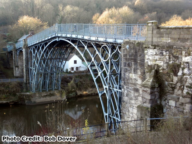
of coke. The bridge at Ironbridge, the world's first bridge constructed of iron, had a considerable influence on developments in the fields of technology and architecture.

Outstanding Universal Value
Brief synthesis

The Ironbridge Gorge World Heritage property covers an area of 5.5 km2 (550 ha) and is located in Telford, Shropshire, approximately 50 km north-west of Birmingham. The Industrial Revolution had its 18th century roots in the Ironbridge Gorge and spread worldwide leading to some of the most far-reaching changes in human history.

The site incorporates a 5 km length of the steep-sided, mineral-rich Severn Valley from a point immediately west of Ironbridge downstream to Coalport, together with two smaller river valleys extending northwards to Coalbrookdale and Madeley.

The Ironbridge Gorge provided the raw materials that revolutionised industrial processes and offers a powerful insight into the origins of the Industrial Revolution and also contains extensive evidence and remains of that period when the area was the focus of international attention from artists, engineers, and writers. The property contains substantial remains of mines, pit mounds, spoil heaps, foundries, factories, workshops, warehouses, iron masters’ and workers’ housing, public buildings, infrastructure, and transport systems, together with the traditional landscape and forests of the Severn Gorge. In addition, there also remain extensive collections of artifacts and archives relating to the individuals, processes and products that made the area so important.

Today, the site is a living, working community with a population of approximately 4000 people as well as a world renowned place to visit. It is also a historic landscape that is interpreted and made accessible through the work of a number of organisations, in particular, the Ironbridge Gorge Museum Trust (established in 1967 to preserve and interpret the remains of the Industrial Revolution within the Ironbridge Gorge) and the Severn Gorge Countryside Trust (established in 1991 to manage the woodland, grassland and associated historic structures in the Gorge).

Within the property, five features are highlighted as of particular interest. It was in Coalbrookdale in 1709 that the Quaker Abraham Darby I developed the production technique of smelting iron with coke which began the great 18th century iron revolution. There still remains a high concentration of 18th and 19th century dwellings, warehouses and public buildings in Coalbrookdale. In Ironbridge, the community draws its name from the famous Iron Bridge erected in 1779 by Abraham Darby III. At the eastern end of Ironbridge stand the remains of two 18th century blast furnaces, the Bedlam Furnaces, built in 1757. In Hay Brook Valley, south of Madeley, lies a large open-air museum which incorporates the remains of the former Blists Hill blast furnaces and Blists Hill brick and tile works. Also of importance is the spectacular Hay Inclined Plane, which connected the Shropshire Canal to the Coalport Canal, which in turn linked with the River Severn. The small community of Jackfield on the south bank of the River Severn was important for navigation, coal mining, clay production, and the manufacture of decorative tiles. Located at the eastern end of the property and on the north bank of the River Severn, industrialisation came to Coalport in the late 18th century and the area is remembered principally for the Coalport China Works.

Criterion (i): The Coalbrookdale blast furnace perpetuates in situ the creative effort of Abraham Darby I who discovered the production technique of smelting iron using coke instead of charcoal in 1709. It is a masterpiece of man's creative genius in the same way as the Iron Bridge, which is the first known metal bridge. It was built in 1779 by Abraham Darby III from the drawings of the architect Thomas Farnolls Pritchard.

Criterion (ii): The Coalbrookdale blast furnace and the Iron Bridge exerted great influence on the development of techniques and architecture.

Criterion (iv): Ironbridge Gorge provides a fascinating summary of the development of an industrial region in modern times. Mining centres, transformation industries, manufacturing plants, workers' quarters, and transport networks are sufficiently well preserved to make up a coherent ensemble whose educational potential is considerable.

Criterion (vi): Ironbridge Gorge, which opens its doors to in excess of 600,000 visitors yearly, is a world renowned symbol of the 18th century Industrial Revolution.

Integrity

The boundary of the property is clearly defined by the steep sided Gorge and encompasses an extraordinary concentration of mining zones, foundries, factories, workshops and warehouses which coexist with the old network of lanes, paths, roads, ramps, canals and railroads as well as substantial remains of traditional landscape and housing. The ironmasters' houses, the workers' living quarters, public buildings and infrastructure are all within the five identifiable areas of Coalbrookdale, Ironbridge, Hay Brook Valley with Madeley, Jackfield and Coalport, which are enclosed by a common boundary. The well preserved historic fabric is well supported by detailed historic archives and collections of manufactured goods. The technologically revolutionary Iron Bridge spanning the River Severn Gorge is the focal point of the property and, together with the attributes above, includes all that is necessary to convey the former pioneering intense industrial past within its green landscape and thus the Outstanding Universal Value of the property.

None of the key industrial attributes are under threat, but the overall mining landscape is vulnerable to land instability resulting from mining, underlying geology and incremental changes, which over time could impact the character of the valley. The landscape is a crucial part of the property, and it needs to be managed as a coherent whole, with key views across the valley identified and protected.

Authenticity

The decline of the industries and the prosperity of the area at the end of the 19th and start of the 20th centuries in a way helped to protect most of the urban fabric within the property and its landscape. The different types of dwellings, industrial buildings and structures did suffer from a degree of neglect following the decline in prosperity. However, in recognition of the area’s unique industrial heritage significant late 20th century investment reversed this decline. With careful attention to details, materials and techniques, most of the historic buildings, structures and urban and rural patterns have retained their essential and authentic historic character, although, some industrial monuments await conservation work.

In 2010, nearly 1 million people visited the Ironbridge Gorge and its museums. The Victorian Town Open Air museum at Blists Hill was established before inscription and incorporates scheduled industrial monuments, reconstructed 19th century buildings and new buildings based on local examples. Care is taken to ensure that the relationship between the original buildings and monuments on the property and the other structures, which do not form part of the historic attributes of the property is clearly stated ensuring authenticity is not compromised.

Protection and management requirements

The UK Government protects World Heritage properties in England in two ways. Firstly, individual buildings, monuments, gardens and landscapes are designated under the Planning (Listed Buildings and Conservation Areas) Act 1990 and the 1979 Ancient Monuments and Archaeological Areas Act and secondly, through the UK Spatial Planning System under the provisions of the Town and Country Planning Acts.

Government guidance on protecting the Historic Environment and World Heritage is set out in the National Planning Policy Framework and Circular 07/09. Policies to protect, promote, conserve and enhance World Heritage properties, their settings and buffer zones are also found in statutory planning documents. World Heritage status is a key material consideration when planning applications are considered by the Local Planning Authority. The Telford & Wrekin Core Strategy contains policies to protect the property. This Strategy is replaced by a Local Plan covering a period of approximately 25 years.

The property lies predominantly in the boundary of Telford & Wrekin Council with a small south-east portion within the Shropshire Council boundary. The entire site is a designated Conservation Area and there are over 375 listed buildings of which two are Grade 1 and eighteen are Grade 2*. In addition, there are 7 Scheduled Ancient Monuments. There are two Sites of Special Scientific Interest within the World Heritage property.

Added control over changes to the property is achieved through an Article 4 (2) Directive for the Conservation Area, which withdraws permitted rights for certain development. Additional controls under a wider Article 4(2) Directive will be implemented in 2013 as an improved management tool to prevent damaging incremental change.

The Ironbridge Gorge World Heritage Site Management Plan is under regular review every ten years. Boundaries and protection mechanisms will be reviewed as part of the management plan process. The delivery of the management plan will be implemented by all partners, in conjunction with and on behalf of, Telford & Wrekin Council and overseen by a World Heritage Site Steering Committee by which the key stakeholders are represented. The day to day management activities are carried out at local level by Telford & Wrekin Council together with diverse organisations, agencies, and owners who have various management responsibilities within the property.

There is a need to ensure that management of the property covers the whole area within the boundaries, including the rich ensemble of minor buildings and the encompassing landscape that together give the major structures such as the Iron Bridge and the Old Furnace at Coalbrookdale their extraordinary social and economic context. The management plan review will look at ways this can be achieved. Land instability resulting from previous mining activity and underlying geology is a significant factor in the Gorge and some stabilisation took place. A comprehensive, holistic management approach is required and works are planned as part of a major phased stabilisation programme. An Environmental Impact Assessment, including heritage assessment, will be undertaken to inform the design process.

There is also a need to promote wider understanding of the scope and extent of the property and its inter-related attributes. A visitor and interpretation centre enables visitors to understand the geographical and geological context to the property and visitors are encouraged to visit the various museums and villages and to walk along the river and the slopes of the Gorge. Additional visitor facilities include upgrading visitor accommodation and a Park and Ride facility. This complements the comprehensive high quality interpretation and education service provided by the ten Ironbridge Museums and the Ironbridge Institute.

Divider

Photo Galleries and Videos: Iron Bridge


View Photo Gallery

Bridge Photo-Documentation

Original / Full Size Photos
A collection of overview and detail photos. This gallery offers photos in the highest available resolution and file size in a touch-friendly popup viewer.
Alternatively, Browse Without Using Viewer

Divider

View Photo Gallery

Bridge Photo-Documentation

Mobile Optimized Photos
A collection of overview and detail photos. This gallery features data-friendly, fast-loading photos in a touch-friendly popup viewer.
Alternatively, Browse Without Using Viewer

Divider

Maps and Links: Iron Bridge

Coordinates (Latitude, Longitude):

Search For Additional Bridge Listings:

HistoricBridges.org Bridge Browser: View listed bridges within 0.5 miles (0.8 kilometers) of this bridge.

HistoricBridges.org Bridge Browser: View listed bridges within 10 miles (16 kilometers) of this bridge.

Additional Maps:

Google Maps

Google Streetview (If Available)

Bing Maps

OpenStreetMap

GeoHack (Additional Links and Coordinates)

Apple Maps (Via DuckDuckGo Search)

Apple Maps (Apple devices only)

MapQuest

HERE We Go Maps

ACME Mapper

Waze Map

Android: Open Location In Your Map or GPS App

Flickr Gallery (Find Nearby Photos)

Wikimedia Commons (Find Nearby Photos)

Directions Via Sygic For Android

Directions Via Sygic For iOS and Android Dolphin Browser

Ordnance Survey Maps (UK Only)


Divider
 
Home Top

Divider

About - Contact

© Copyright 2003-2024, HistoricBridges.org. All Rights Reserved. Disclaimer: HistoricBridges.org is a volunteer group of private citizens. HistoricBridges.org is NOT a government agency, does not represent or work with any governmental agencies, nor is it in any way associated with any government agency or any non-profit organization. While we strive for accuracy in our factual content, HistoricBridges.org offers no guarantee of accuracy. Information is provided "as is" without warranty of any kind, either expressed or implied. Information could include technical inaccuracies or errors of omission. Opinions and commentary are the opinions of the respective HistoricBridges.org member who made them and do not necessarily represent the views of anyone else, including any outside photographers whose images may appear on the page in which the commentary appears. HistoricBridges.org does not bear any responsibility for any consequences resulting from the use of this or any other HistoricBridges.org information. Owners and users of bridges have the responsibility of correctly following all applicable laws, rules, and regulations, regardless of any HistoricBridges.org information.

Admin Login

Divider