This ancient stone arch bridge has been preserved for pedestrian use. A beautiful cast iron bridge, which was the replacement for this bridge, is nearby.
Official Heritage Listing Information and Findings
Listed At: Grade I (Scheduled Monument)
Discussion:
List Entry Number: 1005268
Reasons for Designation Multi-span bridges are
structures of two or more arches supported on piers. They were
constructed throughout the medieval period for the use of pedestrians
and packhorse or vehicular traffic, crossing rivers or streams, often
replacing or supplementing earlier fords.
During the early
medieval period timber was used, but from the 12th century stone (and
later brick) bridges became more common, with the piers sometimes
supported by a timber raft. Most stone or brick bridges were constructed
with pointed arches, although semicircular and segmental examples are
also known. A common medieval feature is the presence of stone ashlar
ribs underneath the arch. The bridge abutments and revetting of the
river banks also form part of the bridge. Where medieval bridges have
been altered in later centuries, original features are sometimes
concealed behind later stonework, including remains of earlier timber
bridges. The roadway was often originally cobbled or gravelled. The
building and maintenance of bridges was frequently carried out by the
church and by guilds, although landowners were also required to maintain
bridges. Medieval multi-span bridges must have been numerous throughout
England, but most have been rebuilt or replaced and less than 200
examples are now known to survive. As a rare monument type largely
unaltered, surviving examples and examples that retain significant
medieval and post- medieval fabric are considered to be of national
importance.
Despite partial demolition and the insertion of a
road surface, the remains of Powick Old Bridge survives comparatively
well and contains a number of architectural features of considerable
interest. Elements of the original structure will remain concealed
behind later stone and brickwork and will provide important information
on its construction and rebuilding. The significance of this site as
part of the defence of Worcester during the Civil War and the battle
fought here considerably enhances the importance of this monument.
History See Details.
Details This record was the
subject of a minor enhancement on 19 May 2015. This record has been
generated from an "old county number" (OCN) scheduling record. These are
monuments that were not reviewed under the Monuments Protection
Programme and are some of our oldest designation records.
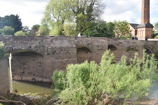
This
monument includes a multi-span bridge situated across Langhern Brook and
the River Teme, west of its confluence with the River Severn, south of
Worcester. The monument survives as a five-span bridge divided into two
sections. The bridge is orientated north east to south west with
Langhern Brook flowing through the two northern arches and the River
Teme passing under the three southern arches. The western side of the
bridge abuts a headland between the river and brook. The bridge was
constructed before 1447 and was partially rebuilt during the 17th
century. It is constructed from stone with brick and is approximately
60m long and up to 7m wide. The bridge has a brick parapet approximately
1m high with chamfered stone coping except on the west where it is
interrupted by a road. The two arches over the brook have segmental
heads and stone voussoirs and the southern arch is brick faced on the
north western side. The three arches over the Teme are higher than the
brook arches and are slightly angled south west to north east to match
the course of the river. The arches are evenly spaced with segmental
heads and stone voussoirs. On the eastern and western sides of the
bridge are three pointed cut waters that rise up to become pedestrian
passing places on the top of the bridge.
The original bridge was
constructed before 1447 by monks from Malvern Priory. In September 1642
a skirmish took place at the bridge that subsequently became known as
the �Battle of Powick Bridge�. The two arches over the brook were
deliberately broken down in 1651 as part of Worcester�s defences during
the battle of Worcester and rebuilt during the 17th century.
Original / Full Size Photos A collection of overview and detail photos. This gallery offers photos in the highest available resolution and file size in a touch-friendly popup viewer. Alternatively, Browse Without Using Viewer
Mobile Optimized Photos A collection of overview and detail photos. This gallery features data-friendly, fast-loading photos in a touch-friendly popup viewer. Alternatively, Browse Without Using Viewer