HistoricBridges.org Menu: HistoricBridges.org Menu:


We Recommend:
Bach Steel - Experts at historic truss bridge restoration.

HistoricBridges.org: Bridge Browser

Spey Viaduct

Speymouth Railway Viaduct

Spey Viaduct

Primary Photographer(s): Nathan Holth

Bridge Documented: May 14, 2018

View Photos
and Videos
View Maps
and Links

Location
Garmouth: Moray, Scotland: United Kingdom
Structure Type
Metal Rivet-Connected Bowstring Through Truss, Fixed and Approach Spans: Metal Rivet-Connected Howe Pony Truss,
Construction Date and Builder / Engineer
1885 By Builder/Contractor: Blaikie Brothers of Aberdeen, Scotland and Engineer/Design: Blyth and Cunningham and Patrick Barnett
Rehabilitation Date
Not Available or Not Applicable
Main Span Length
350.0 Feet (106.7 Meters)
Structure Length
950.0 Feet (289.6 Meters)
Roadway Width
Not Available
Spans
1 Main Span(s) and 6 Approach Span(s)
Inventory Number
Not Applicable

Historic Significance Rating (HSR)
View Information About HSR Ratings

Bridge Documentation

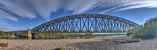
This bridge is noted for its amazing 350 foot clear span, which while not record-breaking, was nevertheless a notable achievement for a clear-span truss at this period in history. The impressive appearance of this bridge is enhanced by its heavy truss members, which are contrasted by the graceful curve of the bowstring design.

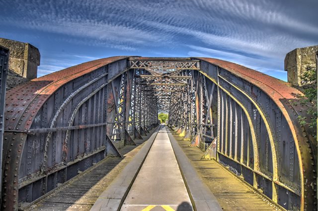
In UK/European vernacular, the approach spans for this bridge are often referred to as lattice girders, although it does not feature a dense lattice web like that found on a traditional lattice girder like the Koblenz Bridge. In American vernacular, these approach spans would be classified as a Howe pony truss. They would be considered a Howe rather than a Double-Intersection Warren because the diagonal members pointing to the top and center of the spans are the heavier members (two pairs of angle with lattice), with counter members being two simple plates/bars.

This bridge has today been converted for pedestrian use. The bridge is an impressive structure that is worth the walk to.

Official Heritage Listing Information and Findings

Listed At: Category B

Discussion:

Historic Environment Scotland Number: LB14873

Canmore ID: 16961

Site Number: NJ36SW 20

Description
Blaikie Bros, 1886. Iron girder railway bridge, 350 foot bowed central truss and, on each side, 3 x 100 foot plain truss approach spans carried on circular ashlar piers with granite capitals.

Statement of Special Interest
Built for the Great North of Scotland Railway. Great length of this viaduct caused by wandering nature of River Spey. Bridge now part of Moray District Speyside Walk.

Canmore Notes:

Built by Blaikie Bros, Aberdeen, in 1886 for the Great North of Scotland Railway between Elgin and the Banffshire coast, to a design by Patrick Barnett, this is an awe-inspiring iron structure thrust between river and sky.

Its great length (290m overall) was determined by the Spey's habit of periodically changing channels in the broad level plain near its mouth. The solution was to build a great bowed central truss, 106.6m long and 13m high, with three 30.5m plain truss approach spans on either side, all supported on circular ashlar piers with granite capitals. When completed the bridge was tested with a load of 400 tons of gravel in 20 trucks; the bridge deflected by 29mm.

Now part of the Speyside Way from Spey Bay to Ballindall och, the walker on the bridge can fully appreciate the confidence of Victorian engineering in erecting this cathedral of grey girders and trusses that arch above the ceaseless, turbid Spey.

This viaduct, built from 1883-86, was constructed to carry the Moray Coast Railway, part of the Great North of Scotland Railway, over the Spey and its floodplain 1 mile south of the coast. The river crossing was initially conceived as three separate bridges spanning the disparate channels, but it was decided to divert the river into a single channel to be crossed on a viaduct with embankment approaches.

The viaduct, 950 ft long, was built to carry a single-track railway. It has an impressive 350 ft long wrought-iron lattice bow girder span over the main channel of the river and three parallel-sided wrought-iron lattice girder approach spans of 100 ft at either end. The lattice members of the main arch, 41 ft deep at mid-span, rise from open box girders at each side of the deck. Cast-iron caissons filled with concrete form the piers of the viaduct. These were sunk to bedrock at depths of 25-35 ft except for the piers at the west end of the central span where it was necessary to sink them to a depth of 75 ft.

The viaduct, erected on a forest of staging, was designed by Blyth and Cunningham and Patrick Barnett, and the contractors for the ironwork of the superstructure were Blaikie Bros., Aberdeen. The contractor for the foundations and masonry was John Fyfe & Co., Kemnay.

At the time of construction, the main channel of the Spey ran to the east of the viaduct, and much of the construction work and work on the concrete spine wall to control the direction of the river was done in the dry. On completion of the bridge the river was diverted beneath the central span.

Divider

Photo Galleries and Videos: Spey Viaduct


View Photo Gallery

Bridge Photo-Documentation

Original / Full Size Photos
A collection of overview and detail photos. This gallery offers photos in the highest available resolution and file size in a touch-friendly popup viewer.
Alternatively, Browse Without Using Viewer

Divider

View Photo Gallery

Bridge Photo-Documentation

Mobile Optimized Photos
A collection of overview and detail photos. This gallery features data-friendly, fast-loading photos in a touch-friendly popup viewer.
Alternatively, Browse Without Using Viewer

Divider

Maps and Links: Spey Viaduct

Coordinates (Latitude, Longitude):

Search For Additional Bridge Listings:

HistoricBridges.org Bridge Browser: View listed bridges within 0.5 miles (0.8 kilometers) of this bridge.

HistoricBridges.org Bridge Browser: View listed bridges within 10 miles (16 kilometers) of this bridge.

Additional Maps:

Google Maps

Google Streetview (If Available)

Bing Maps

OpenStreetMap

GeoHack (Additional Links and Coordinates)

Apple Maps (Via DuckDuckGo Search)

Apple Maps (Apple devices only)

MapQuest

HERE We Go Maps

ACME Mapper

Waze Map

Android: Open Location In Your Map or GPS App

Flickr Gallery (Find Nearby Photos)

Wikimedia Commons (Find Nearby Photos)

Directions Via Sygic For Android

Directions Via Sygic For iOS and Android Dolphin Browser

Ordnance Survey Maps (UK Only)


Divider
 
Home Top

Divider

About - Contact

© Copyright 2003-2024, HistoricBridges.org. All Rights Reserved. Disclaimer: HistoricBridges.org is a volunteer group of private citizens. HistoricBridges.org is NOT a government agency, does not represent or work with any governmental agencies, nor is it in any way associated with any government agency or any non-profit organization. While we strive for accuracy in our factual content, HistoricBridges.org offers no guarantee of accuracy. Information is provided "as is" without warranty of any kind, either expressed or implied. Information could include technical inaccuracies or errors of omission. Opinions and commentary are the opinions of the respective HistoricBridges.org member who made them and do not necessarily represent the views of anyone else, including any outside photographers whose images may appear on the page in which the commentary appears. HistoricBridges.org does not bear any responsibility for any consequences resulting from the use of this or any other HistoricBridges.org information. Owners and users of bridges have the responsibility of correctly following all applicable laws, rules, and regulations, regardless of any HistoricBridges.org information.

Admin Login

Divider