We Recommend:
Bach Steel - Experts at historic truss bridge restoration.
BridgeHunter.com Phase 1 is released to the public! - Visit Now
Cầu Long Biên (Long Bien Bridge)
Paul Doumer Bridge

Primary Photographer(s): Nathan Holth
Bridge Documented: December 2, 2018
Railroad (Hanoi Railway) and Highway Over Red River (Sông Hồng)
Hanoi (Hà Nội): Hanoi (Hà Nội): Vietnam (Việt Nam)
Metal Cantilever 20 Panel Rivet-Connected Warren Through Truss, Fixed and Approach Spans: Metal 10 Panel Rivet-Connected Double-Intersection Warren Pony Truss, Fixed
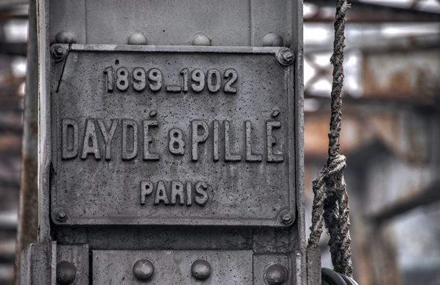
1902 By Builder/Contractor: Daydé and Pillé of Paris, France and Schneider et Cie of Chalon-sur-Saône, France
1972
348.3 Feet (106.2 Meters)
5,643.0 Feet (1720 Meters)
26.4 Feet (8.05 Meters)
19 Main Span(s) and 1 Approach Span(s)
Not Applicable

View Information About HSR Ratings
Bridge Documentation
View Historical Articles About This Bridge
View Historical Catalog For Schneider et Cie of Chalon-sur-Saône, France
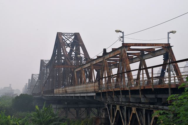
Cầu Long Biên, originally known as the Paul Doumer Bridge, crosses the Red River in Hanoi. One of the most famous bridges in Vietnam, this bridge was built by the French company Daydé & Pillé of Paris in 1903. At the western end of the bridge, a single approach span is present, and this span was built by Schneider et Cie of Chalon-sur-Saône, France. Consisting of a repeating series of cantilever through truss systems (including anchor arms, cantilever arms, and suspended spans) this extremely long bridge (just over a mile in length) is one of the longest cantilever truss bridges in the world, and may also have one of the largest numbers of cantilever truss spans in a single bridge. Half of the bridge is over land and smaller channels of the Red River. The section over the large, main channel of the Red River was almost completely destroyed by bombing during the Vietnam War and only a few spans are original in that area, the destroyed spans having been replaced by new spans. In contrast, the section over land retains its original materials and design. The bridge carries a railway line between the two truss lines. A cantilevered deck is present on the outside of each truss line. Each cantilevered deck contains a lane for motorbike traffic plus a pedestrian sidewalk. The bridge is served by an elevated approach viaduct to the west in Hanoi which includes metal pony truss and concrete deck arch spans over the city streets.
The original spans of this bridge retain the original ornamental railings. The cantilever truss is in terms of its appearance noted for its striking visual contrast between the suspended spans, and the towering cantilever and anchor arms. An unusual design detail is that the suspended spans are not actually "suspended" in the sense that they are not attached to the cantilever arms by way of hangers, but instead they rest on rocker bearings on the cantilever arms.
Above: Historical photo showing bridge construction.
Above: Historical photo showing newly completed bridge.
Above: Historical photo showing newly completed bridge.
Above: Historical photo showing bridge in 1939.
Above: Historical photo showing bridge after destruction in war.
Above: Original drawing for bridge.
![]()
Photo Galleries and Videos: Cầu Long Biên (Long Bien Bridge)
Structure Overview
Original / Full Size PhotosA collection of overview photos that show the bridge as a whole and general areas of the bridge. This gallery offers photos in the highest available resolution and file size in a touch-friendly popup viewer.
Alternatively, Browse Without Using Viewer
![]()
Structure Details
Original / Full Size PhotosA collection of detail photos that document the parts, construction, and condition of the bridge. This gallery offers photos in the highest available resolution and file size in a touch-friendly popup viewer.
Alternatively, Browse Without Using Viewer
![]()
Structure Overview
Mobile Optimized PhotosA collection of overview photos that show the bridge as a whole and general areas of the bridge. This gallery features data-friendly, fast-loading photos in a touch-friendly popup viewer.
Alternatively, Browse Without Using Viewer
![]()
Structure Details
Mobile Optimized PhotosA collection of detail photos that document the parts, construction, and condition of the bridge. This gallery features data-friendly, fast-loading photos in a touch-friendly popup viewer.
Alternatively, Browse Without Using Viewer
![]()
Maps and Links: Cầu Long Biên (Long Bien Bridge)
Coordinates (Latitude, Longitude):
Search For Additional Bridge Listings:
Additional Maps:
Google Streetview (If Available)
GeoHack (Additional Links and Coordinates)
Apple Maps (Via DuckDuckGo Search)
Apple Maps (Apple devices only)
Android: Open Location In Your Map or GPS App
Flickr Gallery (Find Nearby Photos)
Wikimedia Commons (Find Nearby Photos)
Directions Via Sygic For Android
Directions Via Sygic For iOS and Android Dolphin Browser


