

View Information About HSR Ratings
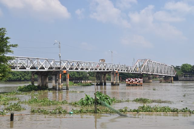
Cầu Phú Long crosses the Sai Gon River between Ho Chi Minh City and Binh Duong. This French bridge built in 1913 by Société de construction de Levallois-Perret. This bridge company was the new name given to Compagnie des établissements Eiffel when famous engineer Gustave Eiffel retired from the board of directors. Thus, bridges associated with this company are often called "Eiffel" bridges although Eiffel was not associated with any bridges built by the company after 1893. Cầu Phú Long includes a main span consisting of a three span continuous truss, where the ends of this three span system are cantilevered out beyond the end of the piers, a very unusual design. The cantilevered ends of the truss have bearing seats that hold the adjacent approach spans, which are riveted pony truss spans. The eastern pony truss span is a European riveted bowstring style span, while the western spans are a riveted double-intersection Warren pony truss design. The western spans, while old and of riveted design, are clearly not be original to the bridge. The piers for these spans are a newer concrete design as well.
Bridge lengths given are very rough estimates. The through truss span is approximately a 300 foot structure, with the span between the two piers that hold the span being 200 feet, making each cantilevered end about 50 feet.
This bridge is slated for demolition as soon as 2019.
![]()
![]()
![]()
This historic bridge has been demolished. This map is shown for reference purposes only.
Coordinates (Latitude, Longitude):
Search For Additional Bridge Listings:
Additional Maps:
Google Streetview (If Available)
GeoHack (Additional Links and Coordinates)
Apple Maps (Via DuckDuckGo Search)
Apple Maps (Apple devices only)
Android: Open Location In Your Map or GPS App
Flickr Gallery (Find Nearby Photos)
Wikimedia Commons (Find Nearby Photos)
Directions Via Sygic For Android
Directions Via Sygic For iOS and Android Dolphin Browser

© Copyright 2003-2024, HistoricBridges.org. All Rights Reserved. Disclaimer: HistoricBridges.org is a volunteer group of private citizens. HistoricBridges.org is NOT a government agency, does not represent or work with any governmental agencies, nor is it in any way associated with any government agency or any non-profit organization. While we strive for accuracy in our factual content, HistoricBridges.org offers no guarantee of accuracy. Information is provided "as is" without warranty of any kind, either expressed or implied. Information could include technical inaccuracies or errors of omission. Opinions and commentary are the opinions of the respective HistoricBridges.org member who made them and do not necessarily represent the views of anyone else, including any outside photographers whose images may appear on the page in which the commentary appears. HistoricBridges.org does not bear any responsibility for any consequences resulting from the use of this or any other HistoricBridges.org information. Owners and users of bridges have the responsibility of correctly following all applicable laws, rules, and regulations, regardless of any HistoricBridges.org information.
![]()