

View Information About HSR Ratings
This bridge is an excellent example of a state standard truss bridge. The bridge also features a t-beam approach span at each end. Initially threatened by demolition and not even considered historic, the bridge's situation prompted Mary M. Root to prepare a preliminary eligibility form to get the bridge evaluated for significance. In completing the form, she describes in detail the description and significance of the bridge. Refer to her extensive findings below. The efforts were fruitful and as of 2020 this bridge has been fully rehabilitated.

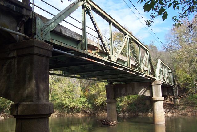
Above: Rehabilitated bridge. Photo Credit: Mary M. Root

Above: Rehabilitated bridge. Photo Credit: Mary M. Root
Information and Findings By Mary M. Root Prepared For Preliminary National Register of Historic Places Eligibility FormPhysical Character of General Surroundings Site Description Notes/Notable Landscape Features: Crosses the Rappahannock River (a State Scenic River) where the river is approximately 160 feet wide and generally in slack water. The river banks are vegetated with indigenous trees and shrubs punctuated by granite rock outcroppings. This section of Business Route 15/29 is on the Journey Through Hallowed Ground and the bridge sits squarely in the middle of the Rappahannock Station I and II Core Battlefield areas. The hills overlooking the nearby railroad bridge and fords were heavily fortified during the Civil War and many skirmishes using the river as a dividing line took place in this vicinity. The battlefields are undeveloped. Just downstream of the bridge can be seen the old stone piers of Bridge 1907's predecessor, when the road traversed the east side of the Culpeper hill, nearer to the railroad tracks. On the Fauquier side of the river can be seen the old foundations of the Morgan (aka Martin) Mill site which also once bore water towers for the railroad's steam engines. The remains of the mill dam across the river create a straight line of riffles in the water. Rising just beyond the old mill dam are the twin Warren truss bridges used by the Norfolk Southern Railroad. Near the Culpeper end of the bridge and down a steep bank, may be seen a large shallow pool where the canal boats were docked for loading and unloading circa 1840-1860, before the railroad dominated the transport of goods. Near the Fauquier end of the bridge, just upstream, is a two-story tower with a metal walkway extending to the bank. This is a USGS real-time river gauge built at the same time as Bridge 1907. Today it transmits river data via satellite antenna and is powered by a small solar panel. Upstream the views of the river and its banks are wild and serene. Secondary Resource Description (Briefly describe any other structures (or archaeological sites) that may contribute to the significance of the property: As mentioned above, the Rappahannock Canal remnants, the Civil War earthworks and battlefields, the river gauge tower, the old roadway bridge piers, the mill foundations and dam, and the railroad bridges. Resource Component Information Foundation: Poured reinforced concrete footers and piers supporting arched concrete pier-caps (the combination referred to as "bents") Structure: The bridge consists of two reinforced concrete approach spans (one on each side of the river), leading to two Warren-With-Verticals twin low pony truss spans. The truss spans are each composed of six panels, with vertical members at each connection. The alloy steel beams are built-up and riveted together, with riveted gusset plates. Channels and beams are connected with battens and v-lacing. Architectural Description of Individual Resource The Warren truss pattern was utilized in 19th and early 20th century bridge building throughout Virginia. The design leant itself to adaptation in varying lengths, widths, topographic features, and loads. The addition of vertical members to the truss design strengthened the individual connection points, while the rivets throughout created a rigid superstructure. The v-lacing ties the elements together both structurally and visually. Significance Statement: A large and extensive road system was already in place in the United States when cars became a major mode of transportation in the early twentieth century. The pattern of the system mirrored land uses and transportation corridors of the nineteenth century. Roads were narrow, primarily composed of dirt and gravel, and for the most part, followed existing topography. In Virginia, local governments were responsible for road and bridge construction, until the Virginia State Highway Commission was organized, and funded in 1927 with a gas tax. The road linking Clarksville, North Carolina to Point of Rocks, Maryland was designated as Route 32 initially, but was reassigned "Route 15" in 1929. This road connected Farmville, Orange, Culpeper, Remington, Warrenton, The Plains, Middleburg, and Leesburg in Virginia, and was an important means of moving agricultural goods through this portion of the state. With the new gas tax funding, new bridges were built along Route 15 in Virginia, engineered for the live loads of cars, trucks and farming machinery and Bridge 1907 in Remington was among them. As part of the State highway construction funds announced in December 1929, the Culpeper District received $1,149,800 for fourteen road projects, including "Route 32 Bridge Rappahannock River, Remington... Amount $50,000." The following Spring, a display advertisement from Shell Eastern Petroleum Products proclaimed "Go Places and See Things - but Dodge That Detour!" extolling the virtues of their free Shell "Travelaide" maps, with "up-to-the-minute NEWS about the condition of roads." The ad's illustration portrayed a typical section of their latest map and a list of current detours, including "U.S. Highway 15 - Bridge construction over Rappahannock River at Remington; new location." A report in September 1930 headlined "Virginia Highways Held in Good Shape" noted "On U.S. Route 15 from the North Carolina line north of Durham, N.C. to the Maryland line at the Point of Rocks, the only construction is a bridge approach near Remington, and this will cause no trouble." The Warren pony truss spans of Bridge 1907 are the result of long-standing designs improved over time, especially with advances in steel alloys. In the early 20th century before the ability to roll steel beams arrived, iron and steel elements were joined together to form large, strong beams called "built-up" beams. Bridge 1907 was created on the factory floor of the Roanoke Iron and Bridge Works in Roanoke, Virginia. The steel arrived at the bridge company by rail; where channels, plates and bars became top chords and end posts, channels and bars were riveted together to form posts, and angles and bars became lateral struts and braces. The bridge parts - cut, drilled, riveted and fitted in the fabrication shop - were fully assembled there in Roanoke, the pieces marked, and the bridge was then disassembled for shipping to Remington, Virginia. The bridge arrived on the Southern Railway train, along with the requisite tools and an erection foreman, sometimes called a bridge master. Under his direction, a locally-hired labor force would erect the bridge. By 1930, portable pneumatic riveters had been developed for field riveting, which made the assembly process easier in the field, and resulted in a more rigid structure. Once common throughout Virginia, Warren pony truss spans have steadily declined in numbers. In 1975, when Dan Grove Deibler compiled A Survey and Photographic Inventory of Metal Truss Bridges in Virginia, 1865-1932, Bridge 1907 was one of 16 metal pony truss spans in the Culpeper District, and one of seven made by the Roanoke Iron and Bridge Works. In 2011, there are few metal truss spans left in Culpeper District, with none remaining by the Roanoke firm, except this bridge. Bridge 1907 is a rare survivor, a bridge built for this exact place in Virginia, made by Virginians. Near the south (Culpeper) end of the bridge, the remnants of the Rappahannock River Canal (circa 1840-1860) may be seen; there is a large shallow pool with only a steep, narrow bank separating it from the roadway. This pool was the docking place for Remington (then known as "Mill View" and sometimes as "Bowensville"), where the canal boats were loaded and unloaded, and it is plotted to scale on the State Highway Plans and Profiles for Bridge 1907's construction, dated October 24, 1927. Canal boats made the up-river journey with manufactured goods, salt, plaster, fertilizer, seed, and fish, and returned to Fredericksburg loaded with flour, wheat, corn, lumber, and firewood. The canal was a financial disaster for its backers because "the project was under-capitalized and burdened with debt, the design was poor, and the river uncooperative." During the canal's useful years, Remington was a busy port; as many as six boats would tie up at a time to discharge and receive their loads at the pool site. Bridge 1907 sits right in the middle of the
Rappahannock Station I and II Core Civil War Battlefield Study Areas.
Here the river was a "daremark line" and the banks and surrounding hills
the scene of three major battles and countless skirmishes. The proximity
of the railroad, whose truss spans echo the shape of Bridge 1907, leant
extra urgency to defending the spot, in order to control the vital
supply line. A succession of railroad bridges were built and destroyed
during the war, the original being a Howe truss bridge. Three Medals of
Honor were awarded after the dramatic nighttime assault and hand-to-hand
combat of November 7, 1863, on ground within sight of this metal truss
bridge. Amid this setting, and along the Journey Through Hallowed
Ground, Bridge 1907 retains the look of that original truss bridge,
retaining a timeless aesthetic appeal. On two of the bridge piers, on the downstream side, there are special markings. On the central river pier, the lines are faded paint, while the Culpeper pier bears chiseled grooves. These marks are a Randy Carter gauge, used for canoeing and kayaking. Randy Carter (1904 - 1974) was a pioneer whitewater canoeist, tireless advocate for the Rappahannock River, and the author of the best of the early whitewater river guidebooks. Mr. Carter devised a system of marking bridge abutments (or piers) to indicate the amount of water available for safe canoeing, and personally created the first gauge on our bridge. Many water trips begin or end at this landmark bridge. Bridge 1907 has weathered historic floods of the Rappahannock River, in April 1937, October 1942, and in June 1972 (Hurricane Agnes). Old-timers remember the 1942 flooding as the worst, when the river crested at 30.0 feet at Remington, fully fifteen feet above flood stage. Former Mayor T. Leo McCarthy said, "It was frightening to see [the water] inching up and the bad part was you didn't know when it would stop." Downtown businesses were flooded, but much of the merchandise was saved by a contingent of residents and business owners. Photographs of the flooding showed people canoeing down Main Street and Route 29. Although Southern Railway brought in 38 carloads of coal to secure their railroad bridge during the flood, similar measures were not taken for Bridge 1907. Both bridges survived. Due to Bridge #1907's site integrity and unique setting within the Rappahannock Station I and II Core Battlefield Study Areas, its crossing of a State Scenic River, the fact it is a rare surviving example of a once-great iron manufacturing works, and that its design is a compatible form to Civil War-era bridges, this bridge should be honored with placement on the National Register of Historic Places. Purpose Evaluation Is Being Sought Bridge 1907 in Remington is a rare survivor of highway modernization, and is one of the last examples of a low pony Warren truss bridge made by the Roanoke Iron and Bridge Works. The riveted metal truss structure exemplifies Virginia's fine civil engineering and bridge manufacturing history. Its site, in a rural area within two core Civil War battlefield study areas, is undeveloped and the bridge is surrounded by trees and the Rappahannock River it spans. It has a visual and cultural relationship with nearby secondary resources, which include the circa 1942 water gauge tower upstream, the stone piers of Bridge 1907's predecessor, and the twin truss railroad bridges downstream. These features along our river are symbolic to Remington and its past. View The Complete Preliminary National Register of Historic Places Eligibility Form With Footnotes |
![]()
![]()
![]()
Coordinates (Latitude, Longitude):
Search For Additional Bridge Listings:
Bridgehunter.com: View listed bridges within 0.5 miles (0.8 kilometers) of this bridge.
Bridgehunter.com: View listed bridges within 10 miles (16 kilometers) of this bridge.
Additional Maps:
Google Streetview (If Available)
GeoHack (Additional Links and Coordinates)
Apple Maps (Via DuckDuckGo Search)
Apple Maps (Apple devices only)
Android: Open Location In Your Map or GPS App
Flickr Gallery (Find Nearby Photos)
Wikimedia Commons (Find Nearby Photos)
Directions Via Sygic For Android
Directions Via Sygic For iOS and Android Dolphin Browser
USGS National Map (United States Only)
Historical USGS Topo Maps (United States Only)
Historic Aerials (United States Only)
CalTopo Maps (United States Only)

© Copyright 2003-2024, HistoricBridges.org. All Rights Reserved. Disclaimer: HistoricBridges.org is a volunteer group of private citizens. HistoricBridges.org is NOT a government agency, does not represent or work with any governmental agencies, nor is it in any way associated with any government agency or any non-profit organization. While we strive for accuracy in our factual content, HistoricBridges.org offers no guarantee of accuracy. Information is provided "as is" without warranty of any kind, either expressed or implied. Information could include technical inaccuracies or errors of omission. Opinions and commentary are the opinions of the respective HistoricBridges.org member who made them and do not necessarily represent the views of anyone else, including any outside photographers whose images may appear on the page in which the commentary appears. HistoricBridges.org does not bear any responsibility for any consequences resulting from the use of this or any other HistoricBridges.org information. Owners and users of bridges have the responsibility of correctly following all applicable laws, rules, and regulations, regardless of any HistoricBridges.org information.
![]()