We Recommend:
Bach Steel - Experts at historic truss bridge restoration.
BridgeHunter.com Phase 1 is released to the public! - Visit Now
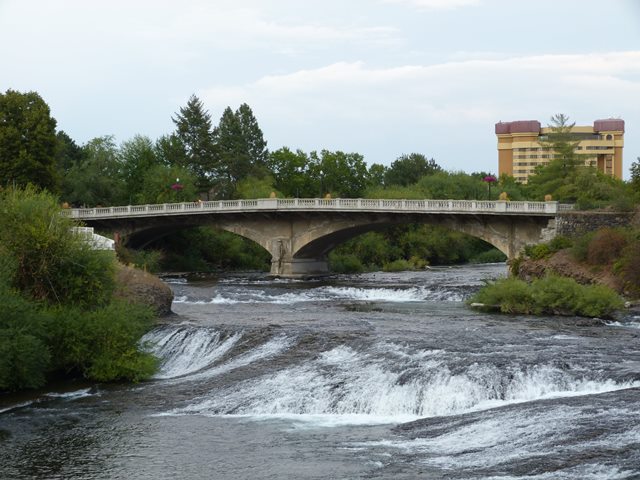
Howard Street North Channel Bridge

Primary Photographer(s): Nathan Holth
Bridge Documented: August 19, 2014
Howard Street (Non-Motorized Traffic Only) Over Spokane River North Channel
Spokane: Spokane County, Washington: United States
Not Available or Not Applicable
106.0 Feet (32.3 Meters)
212.0 Feet (64.6 Meters)
54 Feet (16.46 Meters)
2 Main Span(s)
85296000000000

View Information About HSR Ratings
Bridge Documentation
View Archived National Bridge Inventory Report - Has Additional Details and Evaluation
Howard Street crosses the Spokane River in an area where the river has been divided into three channels. Two of the three Howard Street Bridges are historically significant, this span and the middle channel span, which is a concrete arch bridge and presents a nice contrast and comparison to this bridge. The south channel span is also old, but a more mundane concrete slab or t-beam style structure.
As originally built, the three Howard Street Bridges had to carry pedestrians, vehicular traffic, and two sets of railway tracks in the middle that appear to have been for street cars. The railway portion did not last forever however, and eventually the entire center of the roadway was converted for vehicular traffic. In 1974, the bridges were closed to vehicular traffic for the Expo '74 Worlds Fair which was held near the bridges. The bridges never reopened for vehicular traffic afterward, and have continued to be used for non-motorized traffic only through to the present day.
This bridge is a traditional-looking concrete arch bridge. It includes a cantilevered sidewalk with heavy concrete balustrade railing featuring urn-shaped ballusters.
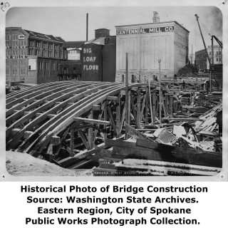
There is a bit of a mystery with this bridge. The bridge seen today is a closed spandrel arch bridge. However, Henry Grattan Tyrrell's History of Bridge Engineering describes a different bridge as follows: "A two span ribbed arch was also built by Mr. Strauss at Howard Street, Spokane, with six ribs and open spandrels. The plan shows brick paving between the car tracks and asphalt at the sides, on a floor slab supported by 12-inch cross walls about 10 feet apart through the central portion, and on spandrel columns and floor beams near the ends." This description and drawing which is shown below appears to be describing a short-lived venture that famous engineer Joseph Strauss made into the concrete bridge business before refining his work to steel and movable bridges. An example is discussed here. It is not known what the story is here. It is possible the bridge was altered some time after it was built perhaps widened and strengthened to accommodate the street car rail lines that for a time ran on Howard for example, or perhaps the Strauss bridge was short-lived and replaced. If that is the case however, than the 1909 construction date given in the National Bridge Inventory would be incorrect. The historical bridge construction photos that were located for this bridge were taken too early in the construction process to see what type of bridge was being built.
![]()
Photo Galleries and Videos: Howard Street North Channel Bridge
Bridge Photo-Documentation
Original / Full Size PhotosA collection of overview and detail photos. This gallery offers photos in the highest available resolution and file size in a touch-friendly popup viewer.
Alternatively, Browse Without Using Viewer
![]()
Bridge Photo-Documentation
Mobile Optimized PhotosA collection of overview and detail photos. This gallery features data-friendly, fast-loading photos in a touch-friendly popup viewer.
Alternatively, Browse Without Using Viewer
![]()
Maps and Links: Howard Street North Channel Bridge
Coordinates (Latitude, Longitude):
Search For Additional Bridge Listings:
Bridgehunter.com: View listed bridges within 0.5 miles (0.8 kilometers) of this bridge.
Bridgehunter.com: View listed bridges within 10 miles (16 kilometers) of this bridge.
Additional Maps:
Google Streetview (If Available)
GeoHack (Additional Links and Coordinates)
Apple Maps (Via DuckDuckGo Search)
Apple Maps (Apple devices only)
Android: Open Location In Your Map or GPS App
Flickr Gallery (Find Nearby Photos)
Wikimedia Commons (Find Nearby Photos)
Directions Via Sygic For Android
Directions Via Sygic For iOS and Android Dolphin Browser
USGS National Map (United States Only)
Historical USGS Topo Maps (United States Only)
Historic Aerials (United States Only)
CalTopo Maps (United States Only)


