

View Information About HSR Ratings
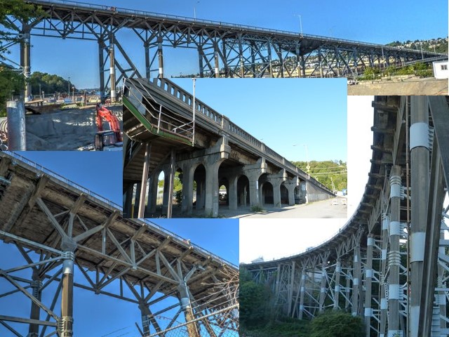
This is a very large and complex bridge with an equally complex history of changes and alteration which are detailed in the next section. The bridge seen today remains historically significant for its large size, and complex arrangement of onramps and offramps that are integrated with the bridge. The area of greatest historic significance is the use of reinforced concrete deck truss spans for the western half of the bridge. Only two concrete truss bridges exist in the state, and nationwide there are only about a handful of examples.
The original bridge was built in 1929. The east end formed an intersection with 15th Avenue West at West Garfield Street, much as it is today. The approach rises at a 5% grade to provide the necessary clearance over the railroad tracks. Shortly after crossing the tracks a two-lane on-off ramp was built in the center of the structure to serve the then Port Commission facilities, with through traffic traveling either side of this ramp. At near the half way point two ramps were built on each side of the bridge to connect to the 23rd Avenue West trestle which connected to Magnolia hill at 23rd and West Newton Street. From this point the main bridge then rises at a 6% grade to connect to the hill at West Galer Street near Dartmouth Avenue West. The original structure is poured in place concrete. All elements, footings, columns, bracing, deck, sidewalk and railings were concrete. The exception was the two ramps connecting to 23rd which were wooden trestles as was the 23rd trestle. (Vault Plan 782-39) The 23rd Avenue West trestle and ramps were removed sometime prior to 1946. (See 1946 aerial photo) Presumably this occurred when the Navy condemned the property and built their facility in 1942.
In 1957 a new grade separation structure was built at the east end of the bridge. This allowed north bound traffic on Elliot Avenue West to go over 15th Avenue West and connect directly to the bridge just west of the railroad tracks. This structure has "T" shaped column-bents with concrete girders and concrete deck. The five support columns west of the railroad tracks were built to match the octagonal shape of the original bridge columns. (Vault Plan 782-94)
In 1960 the first of two projects was done to strengthen the west half of the bridge. This project installed steel cross bracing at six locations to provide additional strength in the longitudinal direction. (Vault Plan 782-100) The second project, completed in 1961, installed steel trusses for deck slab stiffening; removed the north sidewalk and rail, replacing with a facia beam and an aluminum tubular rail; removed a portion of the south sidewalk, replacing with facia beam and a standard aluminum pedestrian railing; and installed new light poles (Vault Plan 782-104)
In 1974 the eastern half of the bridge was retrofitted with steel trusses to provide additional strength to the deck slab, similar to what was done on the westerly portion in 1961. (Vault Plan 777-222) In 1981 the north side rail that was installed in 1961 was removed and replaced with a Jersey-type concrete barrier-railing. The same type barrier was placed along the south curb line to protect pedestrians from moving traffic. (Vault Plan 782-147)
In 1991 new ramps were constructed to serve the Elliot Bay Marina. These were connected to the ramp stubs that were left from removal of the old 23rd Avenue trestle in the early 40's. These ramps are concrete with battered steel column supports. (Vault Plan 782-131)
In 1997 a landslide damaged the bracing between the bridge columns at the westerly most end of the bridge. New steel cross bracing and deck support structures were installed to repair and strengthen this section of the bridge. (Vault Plan 782-200)
The bridge was again damaged by the February 28, 2001 Nisqually earthquake. Nearly half of the original concrete lateral braces from bent 49 through bent 75 were damaged beyond repair. All of the concrete braces within this section of the bridge were replaced with tubular steel bracing. (Vault Plan 782-234)
![]()
![]()
![]()
Coordinates (Latitude, Longitude):
Search For Additional Bridge Listings:
Bridgehunter.com: View listed bridges within 0.5 miles (0.8 kilometers) of this bridge.
Bridgehunter.com: View listed bridges within 10 miles (16 kilometers) of this bridge.
Additional Maps:
Google Streetview (If Available)
GeoHack (Additional Links and Coordinates)
Apple Maps (Via DuckDuckGo Search)
Apple Maps (Apple devices only)
Android: Open Location In Your Map or GPS App
Flickr Gallery (Find Nearby Photos)
Wikimedia Commons (Find Nearby Photos)
Directions Via Sygic For Android
Directions Via Sygic For iOS and Android Dolphin Browser
USGS National Map (United States Only)
Historical USGS Topo Maps (United States Only)
Historic Aerials (United States Only)
CalTopo Maps (United States Only)

© Copyright 2003-2024, HistoricBridges.org. All Rights Reserved. Disclaimer: HistoricBridges.org is a volunteer group of private citizens. HistoricBridges.org is NOT a government agency, does not represent or work with any governmental agencies, nor is it in any way associated with any government agency or any non-profit organization. While we strive for accuracy in our factual content, HistoricBridges.org offers no guarantee of accuracy. Information is provided "as is" without warranty of any kind, either expressed or implied. Information could include technical inaccuracies or errors of omission. Opinions and commentary are the opinions of the respective HistoricBridges.org member who made them and do not necessarily represent the views of anyone else, including any outside photographers whose images may appear on the page in which the commentary appears. HistoricBridges.org does not bear any responsibility for any consequences resulting from the use of this or any other HistoricBridges.org information. Owners and users of bridges have the responsibility of correctly following all applicable laws, rules, and regulations, regardless of any HistoricBridges.org information.
![]()