

View Information About HSR Ratings
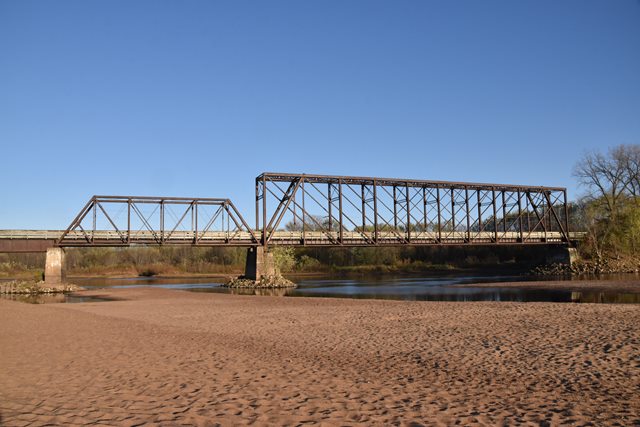
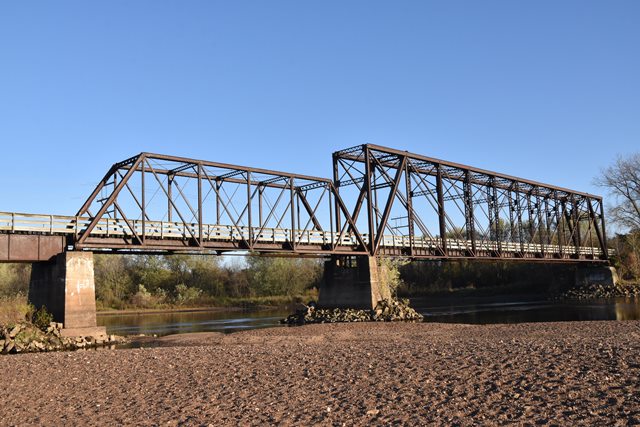
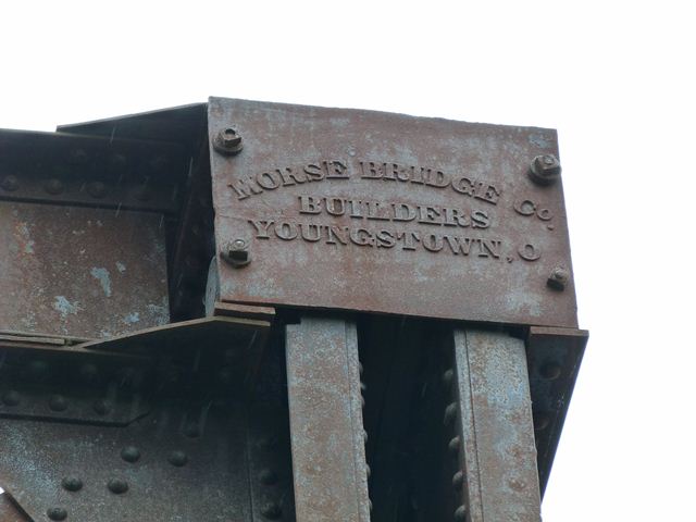
This is an extremely unusual and fascinating historic bridge that likely has an interesting story. The two truss spans are highly significant, in particular the very rare Whipple truss main span which also has vertical end posts. This Whipple truss span has, at one end, Morse Bridge Company builder plaques. The Morse Bridge Company only operated from 1878 to 1888 so the span must date to somewhere in that range, making it a very old surviving railroad truss span. The Pratt truss span next to the Whipple truss span is quite different in appearance from the Whipple truss span. The Pratt truss span has decorative flower buttons on the portal bracing. The differences between the Whipple and Pratt truss spans immediately leads to numerous questions about the history of this crossing. Could it be that these two spans were originally located in other places and were moved here and reused to create this bridge? What other explanation could exist for using two very different designs of truss right next to each other? Why does the Whipple truss have vertical end posts, but the Pratt truss has inclined end posts? John Marvig notes that the Pratt truss span is a known 1885-1886 design and may date to that time. Another aspect of the history of this bridge is its piers appear to be concrete... suggesting a more recent construction/reconstruction of the substructure.
John Marvig did extensive research and after an exhaustive search he figured out the story of this bridge, which is extremely complicated. The key finding was the source of the unusual Whipple truss which was the previous bridge at Kingsford.
The bridge consists of the following spans:
2 Spans Pine Trestle, constructed 1930
1-233'6" Whipple Through Truss, converted from a deck truss built ca. 1881 and moved here from Bridge #U-464; Iron Mountain (Kingsford), MI; moved here 1908
1-103'6" Pratt Through Truss, originally constructed in 1886 at Bridge #B-256 (Spring Green, Wisconsin) and moved here in 1928
2-84' Twinned Deck Girders, Originally built at Bridge #Z-100, Fox River (Elgin, IL) in 1881, replaced 1920-1, and moved here and twinned 1928
14 Span Pile Trestle (332') Renewed 1932
Information comes from the La Crosse & River Division bridge index at the Milwaukee Central Library (Box 79, Folder 1)
![]()
![]()
![]()

![]()
![]()
![]()
![]()
Coordinates (Latitude, Longitude):
Search For Additional Bridge Listings:
Bridgehunter.com: View listed bridges within 0.5 miles (0.8 kilometers) of this bridge.
Bridgehunter.com: View listed bridges within 10 miles (16 kilometers) of this bridge.
Additional Maps:
Google Streetview (If Available)
GeoHack (Additional Links and Coordinates)
Apple Maps (Via DuckDuckGo Search)
Apple Maps (Apple devices only)
Android: Open Location In Your Map or GPS App
Flickr Gallery (Find Nearby Photos)
Wikimedia Commons (Find Nearby Photos)
Directions Via Sygic For Android
Directions Via Sygic For iOS and Android Dolphin Browser
USGS National Map (United States Only)
Historical USGS Topo Maps (United States Only)
Historic Aerials (United States Only)
CalTopo Maps (United States Only)

© Copyright 2003-2024, HistoricBridges.org. All Rights Reserved. Disclaimer: HistoricBridges.org is a volunteer group of private citizens. HistoricBridges.org is NOT a government agency, does not represent or work with any governmental agencies, nor is it in any way associated with any government agency or any non-profit organization. While we strive for accuracy in our factual content, HistoricBridges.org offers no guarantee of accuracy. Information is provided "as is" without warranty of any kind, either expressed or implied. Information could include technical inaccuracies or errors of omission. Opinions and commentary are the opinions of the respective HistoricBridges.org member who made them and do not necessarily represent the views of anyone else, including any outside photographers whose images may appear on the page in which the commentary appears. HistoricBridges.org does not bear any responsibility for any consequences resulting from the use of this or any other HistoricBridges.org information. Owners and users of bridges have the responsibility of correctly following all applicable laws, rules, and regulations, regardless of any HistoricBridges.org information.
![]()