We Recommend:
Bach Steel - Experts at historic truss bridge restoration.
Turtleville Iron Bridge
Lathers Road Bridge

Primary Photographer(s): Nathan Holth and Rick McOmber
Bridge Documented: June 30, 2009 and May 23, 2022
Rural: Rock County, Wisconsin: United States
1887 By Builder/Contractor: Wisconsin Bridge and Iron Company of Milwaukee, Wisconsin
Not Available or Not Applicable
141.3 Feet (43.1 Meters)
147.3 Feet (44.9 Meters)
14.1 Feet (4.3 Meters)
1 Main Span(s)
P53016200000000

View Information About HSR Ratings
Bridge Documentation
This bridge is a significant and relatively early example of a pin-connected highway truss built by an important Wisconsin bridge builder, the Wisconsin Bridge and Iron Company. In 1870, the company was formed with the label Weinhagen Brothers, Engineers. In 1880, the familiar name that would live on into the 20th Century was put in place, Wisconsin Bridge and Iron Company. While largely a regional company, their work, especially into the first half of the 20th Century extended to a more national level. The company became one of the largest fabricators of structural steel in the state. After well over a century of operation, the company was ended in 1983.
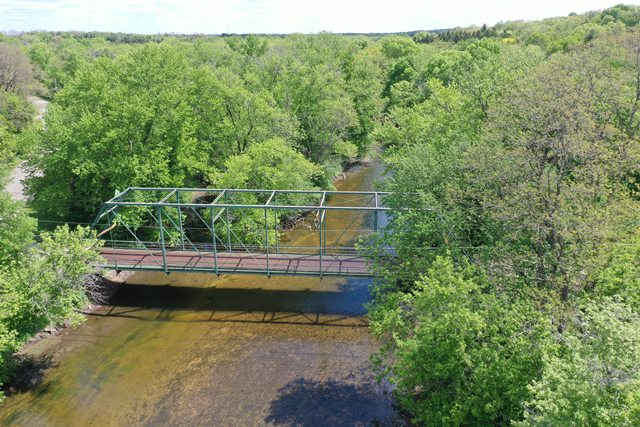
The Lathers Road Bridge, which is 16.2 feet wide, contains eight panels, and is 147.3 feet long, is a fairly long example of a single-span pin-connected Pratt truss. Its length results in higher trusses with more extensive sway bracing than are present on the average length Pratts of this period. The bridge retains good historic integrity. The replacement of the wooden deck with a metal grate in the 1970s is not a significant detriment because it did not alter the truss itself.
This bridge was apparently slated for demolition back in 1984. Obviously, someone at that time saw the good sense in canceling those plans and instead the bridge appears to have been rehabilitated. It is strongly hoped that the preservation commitment to this bridge will remain strong in the years ahead, in the form of continuing maintenance and rehabilitation as needed.
View Archived National Bridge Inventory Report - Has Additional Details and Evaluation
View Historic American Engineering Record (HAER) Documentation For This Bridge
HAER Data Pages, PDF

Photo Credit: Mark Boettcher
This bridge is tagged with the following special condition(s): Unorganized Photos
![]()
Photo Galleries and Videos: Turtleville Iron Bridge
Bridge Photo-Documentation
Original / Full Size PhotosA collection of overview and detail photos. This gallery offers photos in the highest available resolution and file size in a touch-friendly popup viewer.
Alternatively, Browse Without Using Viewer
![]()
Bridge Photo-Documentation
Mobile Optimized PhotosA collection of overview and detail photos. This gallery features data-friendly, fast-loading photos in a touch-friendly popup viewer.
Alternatively, Browse Without Using Viewer
![]()
Additional Unorganized Photos
Original / Full Size PhotosA supplemental collection of photos that are from additional visit(s) to the bridge and have not been organized or captioned. This gallery offers photos in the highest available resolution and file size in a touch-friendly popup viewer.
Alternatively, Browse Without Using Viewer
![]()
Additional Unorganized Photos
Mobile Optimized PhotosA supplemental collection of photos that are from additional visit(s) to the bridge and have not been organized or captioned. This gallery features data-friendly, fast-loading photos in a touch-friendly popup viewer.
Alternatively, Browse Without Using Viewer
![]()
Drone Footage, Courtesy Mark Boettcher
Full Motion VideoNote: The downloadable high quality version of this video (available on the video page) is well worth the download since it offers excellent 1080 HD detail and is vastly more impressive than the compressed streaming video. Streaming video of the bridge. Also includes a higher quality downloadable video for greater clarity or offline viewing.
![]()
Driving Over Bridge, Courtesy Mark Boettcher
Full Motion VideoThis video includes the sound the deck makes when driving over it. Note: The downloadable high quality version of this video (available on the video page) is well worth the download since it offers excellent 1080 HD detail and is vastly more impressive than the compressed streaming video. Streaming video of the bridge. Also includes a higher quality downloadable video for greater clarity or offline viewing.
![]()
Maps and Links: Turtleville Iron Bridge
Coordinates (Latitude, Longitude):
Search For Additional Bridge Listings:
Bridgehunter.com: View listed bridges within 0.5 miles (0.8 kilometers) of this bridge.
Bridgehunter.com: View listed bridges within 10 miles (16 kilometers) of this bridge.
Additional Maps:
Google Streetview (If Available)
GeoHack (Additional Links and Coordinates)
Apple Maps (Via DuckDuckGo Search)
Apple Maps (Apple devices only)
Android: Open Location In Your Map or GPS App
Flickr Gallery (Find Nearby Photos)
Wikimedia Commons (Find Nearby Photos)
Directions Via Sygic For Android
Directions Via Sygic For iOS and Android Dolphin Browser
USGS National Map (United States Only)
Historical USGS Topo Maps (United States Only)
Historic Aerials (United States Only)
CalTopo Maps (United States Only)


