

View Information About HSR Ratings
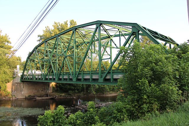
The Capon Bridge, located in Capon Bridge, Hampshire County, West Virginia carries US-50 over the Cacapon River. The bridge is a Parker through truss bridge with riveted connections and a 180 foot span length. The bridge was built in 1933 according to a state highway department design by E. R. Mills using steel supplied by the Wheeling Structural Steel Company. The bridge includes a cantilevered sidewalk on one side. Earlier bridges at this location included a two-span pin-connected half-hip pony truss bridge, and a Burr Arch covered bridge.
This bridge is a landmark for the community, and efforts by local citizens were successful in convincing the West Virginia Department of Highways to rehabilitate this bridge for continued vehicular use, a project that is now in the planning stages as of 2018.
The bridge today retains excellent historic integrity with no major alterations. Railings presently along the roadway and on the sidewalk are original. The only minor alteration appears to be the removal of some portions of the portal bracing to increase vertical clearance for trucks. This is a common alteration for bridges of this age nationwide, as bridges built during this period typically had the load capacity to carry truck loads, but they were built with overhead clearance that is less than that required for many trucks today.
Bridges like the Capon Bridge may not be as old as some metal truss bridges, but this does not mean that they are not significant and not important to preserve. Bridges from the period of the Capon Bridge document a noteworthy period in the development of bridges in the United States. In understanding the history of metal truss highway bridge design, particularly with small and medium-sized spans, two eras are evident. The first era began in the 19th century and lasted into the 1910s. During this era, bridge companies were responsible for both the design and construction of bridges. Bridge salesmen (agents) would market their bridges with various sizes and capacities to government agencies who would choose the bridge that fit their needs and budget. The result of this was a period where the builder of a bridge can often be determined by noting the design details unique to a particular company. Starting in early 1900s, this began to change. State highway departments were formed and these agencies developed their own standard bridge designs and details. State and local governments could then use these standards to designate a particular design of bridge to be built by a bridge contractor. This largely ended the practice of bridge companies designing and selling their own bridge designs, and began the modern system of competitive bidding by contractors to build a bridge following design plans provided by the highway agency. Because the practice of developing bridge design standards occurred at the state level, rather than the federal level, truss bridges built during this period often share the same design features as other truss bridges from this period in the same state. However, design details do vary from state to state. For example, some states preferred Warren truss bridges, others preferred Pratt trusses. Some states made extensive use of v-lacing and lattice in bridge members, while others became early adopters of rolled beams in truss members. Because of these variances, it is important that each state identify and preserve representative examples of its state-designed trusses as a record of their highway department’s truss bridge design efforts. The preservation of the Capon Bridge in West Virginia will help ensure that West Virginia’s state highway truss bridge design is not lost to history.
![]()
![]()
![]()
Coordinates (Latitude, Longitude):
Search For Additional Bridge Listings:
Bridgehunter.com: View listed bridges within 0.5 miles (0.8 kilometers) of this bridge.
Bridgehunter.com: View listed bridges within 10 miles (16 kilometers) of this bridge.
Additional Maps:
Google Streetview (If Available)
GeoHack (Additional Links and Coordinates)
Apple Maps (Via DuckDuckGo Search)
Apple Maps (Apple devices only)
Android: Open Location In Your Map or GPS App
Flickr Gallery (Find Nearby Photos)
Wikimedia Commons (Find Nearby Photos)
Directions Via Sygic For Android
Directions Via Sygic For iOS and Android Dolphin Browser
USGS National Map (United States Only)
Historical USGS Topo Maps (United States Only)
Historic Aerials (United States Only)
CalTopo Maps (United States Only)

© Copyright 2003-2026, HistoricBridges.org. All Rights Reserved. Disclaimer: HistoricBridges.org is a volunteer group of private citizens. HistoricBridges.org is NOT a government agency, does not represent or work with any governmental agencies, nor is it in any way associated with any government agency or any non-profit organization. While we strive for accuracy in our factual content, HistoricBridges.org offers no guarantee of accuracy. Information is provided "as is" without warranty of any kind, either expressed or implied. Information could include technical inaccuracies or errors of omission. Opinions and commentary are the opinions of the respective HistoricBridges.org member who made them and do not necessarily represent the views of anyone else, including any outside photographers whose images may appear on the page in which the commentary appears. HistoricBridges.org does not bear any responsibility for any consequences resulting from the use of this or any other HistoricBridges.org information. Owners and users of bridges have the responsibility of correctly following all applicable laws, rules, and regulations, regardless of any HistoricBridges.org information.
![]()