

View Information About HSR Ratings
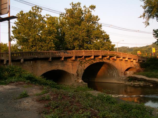
This bridge is the oldest bridge in West Virginia. It has carried such prominent American figures as Andrew Jackson, James K. Polk, William Henry Harrison, Henry Clay, and Daniel Webster across Wheeling Creek. As an 1817 structure, is is also among the oldest extant bridges in the country. It enjoys further technological significance as a relatively rare example of a stone arch that features the elliptical style of arch. The three span structure was altered in the 1950s when a concrete veneer was plastered over the stone, making it look like a concrete arch bridge. Today, some of that concrete is peeling off, so the stone is visible on a couple places. The railings and sidewalks on the bridge are concrete and are not original, although the concrete railings are still decorative in design and are not modern, dating to a 1931 alteration.
This bridge was both proposed and built by a man named Moses Shepherd who was friends with who was at the time House Speaker Henry Clay. Through this friendship, Shepherd was able to get the contracts to build bridges on a section of the National Road, including the Elm Grove Stone Bridge. He further used his influence to get the Elm Grove Stone Bridge built in a different location than originally proposed, even though it required an extra bridge. This was done so the National Road went by his plantation called Shepherd Hall. He also built a monument to Henry Clay in front of Shepherd Hall to honor Clay's involvement with the National Road. The monument is today demolished, but this monument is what later caused Shepherd Hall to be called Monument Place, and the bridge in turn, the Monument Place Bridge.
The West Virginia National Road Alliance has proposed some changes to the Elm Grove setting, including the rehabilitation of the historic bridge. It is assumed that any rehabilitation would include the removal of the concrete veneer to reveal the beautiful stonework below. In their words, their proposal is:
A site of tremendous importance to the National Road is
Monument Place, the location of Shepherd Hall, the former Fort Shepherd, the
former Clay Monument, the historic Elm Grove Stone Bridge, and the intersection
of National Road/ Route 40 and Interstate 70. The history of the site deserves
special attention, as does the importance of this transportation node. The
National Road makes a 90- degree turn here due to the Shepherd's efforts and it
is here that hundreds of tour buses pass on their way to Oglebay and other local
tourist attractions.
Draw attention to the importance of this site by reconstruction of the Clay
Monument, adding sidewalks linking the Monument Place intersection to the other
side of the highway, removing the rusted chain link fence or replacing it with a
decorative fence, planting street trees along National Road, building decorative
pavement crosswalks with coordinated crossing signals, providing access to
historical markers with landscape enhancements, and access to the Wheeling
Creek. Other possibilities include seating at Monument Place intersection,
perhaps partnering with McDonalds and the Osiris Shrine, an overlook at the
South East corner of the Stone Bridge, coordination with the bridge
rehabilitation, interpretive and way finding signage, landscaping at
intersections on both sides of highway, street and accent lighting, kiosks, and
perhaps a literal gateway over the Monument Place intersection.
![]()
![]()
Coordinates (Latitude, Longitude):
Search For Additional Bridge Listings:
Bridgehunter.com: View listed bridges within 0.5 miles (0.8 kilometers) of this bridge.
Bridgehunter.com: View listed bridges within 10 miles (16 kilometers) of this bridge.
Additional Maps:
Google Streetview (If Available)
GeoHack (Additional Links and Coordinates)
Apple Maps (Via DuckDuckGo Search)
Apple Maps (Apple devices only)
Android: Open Location In Your Map or GPS App
Flickr Gallery (Find Nearby Photos)
Wikimedia Commons (Find Nearby Photos)
Directions Via Sygic For Android
Directions Via Sygic For iOS and Android Dolphin Browser
USGS National Map (United States Only)
Historical USGS Topo Maps (United States Only)
Historic Aerials (United States Only)
CalTopo Maps (United States Only)

© Copyright 2003-2024, HistoricBridges.org. All Rights Reserved. Disclaimer: HistoricBridges.org is a volunteer group of private citizens. HistoricBridges.org is NOT a government agency, does not represent or work with any governmental agencies, nor is it in any way associated with any government agency or any non-profit organization. While we strive for accuracy in our factual content, HistoricBridges.org offers no guarantee of accuracy. Information is provided "as is" without warranty of any kind, either expressed or implied. Information could include technical inaccuracies or errors of omission. Opinions and commentary are the opinions of the respective HistoricBridges.org member who made them and do not necessarily represent the views of anyone else, including any outside photographers whose images may appear on the page in which the commentary appears. HistoricBridges.org does not bear any responsibility for any consequences resulting from the use of this or any other HistoricBridges.org information. Owners and users of bridges have the responsibility of correctly following all applicable laws, rules, and regulations, regardless of any HistoricBridges.org information.
![]()