

View Information About HSR Ratings
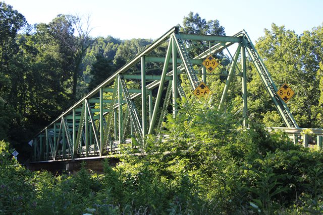
This unusual continuous through truss appears to be been moved here from another location, or otherwise has been significantly altered from its original design and span configuration. The bridge appears to have been longer in its original location as the ends of the top chord look like they were cut off. Furhermore, other truss bridge parts appear to have been salvaged and reused in this bridge's approach span. There was indeed a bridge built at this location in 1911. However, the trusses seen on the bridge today look newer than 1911. It is possible the piers of the bridge date to 1911 but that the truss seen today was moved to replace a 1911 superstructure at a later date.
The truss top and bottom chords are not parallel, the truss is deeper at one end than the other. This is the sort of detail that might present in portion of a very large bridge such as a cantilever truss bridge. Another slim possibility is that it is composed of parts salvaged from the demolition of a bridge like the old Hi Carpenter Bridge.
The bridge built in 1911 was mainly built to serve the needs of the nearby Fairmont Coal Company, which was owned by the Consolidation Coal Company.
![]()
![]()
![]()
Coordinates (Latitude, Longitude):
Search For Additional Bridge Listings:
Bridgehunter.com: View listed bridges within 0.5 miles (0.8 kilometers) of this bridge.
Bridgehunter.com: View listed bridges within 10 miles (16 kilometers) of this bridge.
Additional Maps:
Google Streetview (If Available)
GeoHack (Additional Links and Coordinates)
Apple Maps (Via DuckDuckGo Search)
Apple Maps (Apple devices only)
Android: Open Location In Your Map or GPS App
Flickr Gallery (Find Nearby Photos)
Wikimedia Commons (Find Nearby Photos)
Directions Via Sygic For Android
Directions Via Sygic For iOS and Android Dolphin Browser
USGS National Map (United States Only)
Historical USGS Topo Maps (United States Only)
Historic Aerials (United States Only)
CalTopo Maps (United States Only)

© Copyright 2003-2024, HistoricBridges.org. All Rights Reserved. Disclaimer: HistoricBridges.org is a volunteer group of private citizens. HistoricBridges.org is NOT a government agency, does not represent or work with any governmental agencies, nor is it in any way associated with any government agency or any non-profit organization. While we strive for accuracy in our factual content, HistoricBridges.org offers no guarantee of accuracy. Information is provided "as is" without warranty of any kind, either expressed or implied. Information could include technical inaccuracies or errors of omission. Opinions and commentary are the opinions of the respective HistoricBridges.org member who made them and do not necessarily represent the views of anyone else, including any outside photographers whose images may appear on the page in which the commentary appears. HistoricBridges.org does not bear any responsibility for any consequences resulting from the use of this or any other HistoricBridges.org information. Owners and users of bridges have the responsibility of correctly following all applicable laws, rules, and regulations, regardless of any HistoricBridges.org information.
![]()