We Recommend:
Bach Steel - Experts at historic truss bridge restoration.
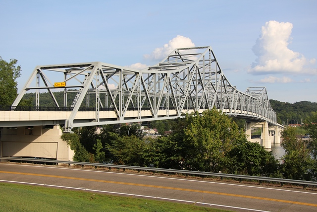
Winfield Toll Bridge
Ross Booth Memorial Bridge

Primary Photographer(s): Rick McOmber
Bridge Documented: August 17, 2019
WV-34 Over Kanawha River, WV-62, and Railroad (Norfolk Southern)
Winfield: Putnam County, West Virginia: United States
Metal Cantilever 18 Panel Rivet-Connected Warren Through Truss, Fixed and Approach Spans: Metal Stringer (Multi-Beam), Fixed
1955 By Builder/Contractor: Vincennes Bridge Company of Vincennes, Indiana and John F. Beasley Company of Muskogee, Oklahoma and Engineer/Design: Harrington and Cortelyou
2010
462.0 Feet (140.8 Meters)
1,433.5 Feet (436.9 Meters)
28 Feet (8.53 Meters)
3 Main Span(s) and 7 Approach Span(s)
40A035

View Information About HSR Ratings
Bridge Documentation
The Winfield Toll Bridge appears to be an example of a significant and increasingly rare bridge type. Generally reserved for long-span river crossings, riveted cantilever truss bridges like the Winfield Toll Bridge are among the largest and most iconic of bridges in the United States. Due to construction costs, the number of bridges that cross a large river is generally smaller than the number of bridges that cross small rivers. Since cantilever bridges are typically crossings for large rivers, the total number of existing cantilever truss bridges is relatively small. To make matters worse, riveted cantilever truss bridges have in recent years faced an alarming rate of demolition. Constructed in 1955, the Winfield Toll Bridge is a later example of a riveted cantilever truss bridge. Bridges of this type were first built in the late 19th Century and became increasingly popular in the first few decades of the 20th Century. Nearly all of the 19th Century examples were replaced years ago, and today it is the bridges from the 1920s through the 1940s that are being replaced at a rapid rate today nationwide.
Earlier significant riveted cantilever truss bridges in and along West Virginia’s borders have been or are to be replaced in the immediate future.
The loss of these bridges leaves the Winfield Toll Bridge as one of the oldest of the very small number of surviving highway cantilever truss bridges in West Virginia. Because of the loss of the aforementioned earlier examples, the 1955 Winfield Toll Bridge has gained historic and technological significance as a representative example of a complex and noteworthy bridge type. Like most cantilever truss bridges, the Winfield Toll Bridge’s size and complex truss configuration make the bridge an example of a significant engineering achievement. It also makes use of historical construction and fabrication techniques, particularly the use of rivets to compose built-up beams. The bridge appears to retain good historic integrity with no major alterations apparent.
View Archived National Bridge Inventory Report - Has Additional Details and Evaluation
View National Register of Historic Places Nomination Form For This Bridge
![]()
Photo Galleries and Videos: Winfield Toll Bridge
Bridge Photo-Documentation
Original / Full Size PhotosA collection of overview and detail photos. This gallery offers photos in the highest available resolution and file size in a touch-friendly popup viewer.
Alternatively, Browse Without Using Viewer
![]()
Bridge Photo-Documentation
Mobile Optimized PhotosA collection of overview and detail photos. This gallery features data-friendly, fast-loading photos in a touch-friendly popup viewer.
Alternatively, Browse Without Using Viewer
![]()
Maps and Links: Winfield Toll Bridge
Coordinates (Latitude, Longitude):
Search For Additional Bridge Listings:
Bridgehunter.com: View listed bridges within 0.5 miles (0.8 kilometers) of this bridge.
Bridgehunter.com: View listed bridges within 10 miles (16 kilometers) of this bridge.
Additional Maps:
Google Streetview (If Available)
GeoHack (Additional Links and Coordinates)
Apple Maps (Via DuckDuckGo Search)
Apple Maps (Apple devices only)
Android: Open Location In Your Map or GPS App
Flickr Gallery (Find Nearby Photos)
Wikimedia Commons (Find Nearby Photos)
Directions Via Sygic For Android
Directions Via Sygic For iOS and Android Dolphin Browser
USGS National Map (United States Only)
Historical USGS Topo Maps (United States Only)
Historic Aerials (United States Only)
CalTopo Maps (United States Only)


