We Recommend:
Bach Steel - Experts at historic truss bridge restoration.
BridgeHunter.com Phase 1 is released to the public! - Visit Now
Folsom Truss Bridge
Walker Bridge / Donald W. Alden Memorial Bridge

Primary Photographer(s): Nathan Holth
Bridge Documented: April 6, 2013
Folsom: Sacramento County, California: United States
1893 By Builder/Contractor: San Francisco Bridge Company of San Francisco, California
2000
330.0 Feet (100.6 Meters)
330.0 Feet (100.6 Meters)
18 Feet (5.49 Meters)
1 Main Span(s)
Not Applicable

View Information About HSR Ratings
Bridge Documentation
View Historic American Engineering Record (HAER) Documentation For This Bridge
HAER Data Pages, PDF
View A Historical Article Discussing This Bridge
View A San Francisco Bridge Company Catalog
An Epic Historic Bridge Story
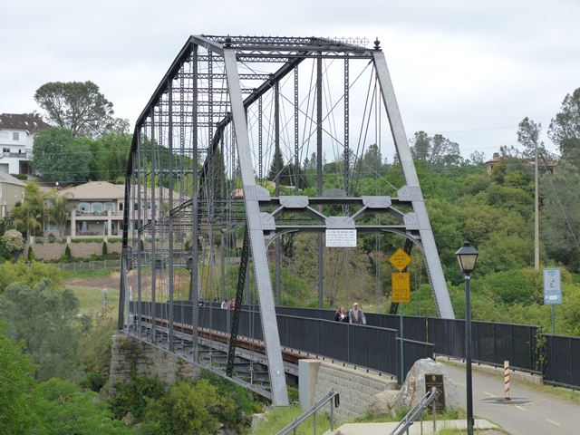
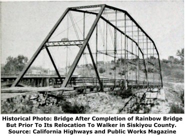
Both in historic times and the present day, pin-connected metal truss bridges (being easy to dismantle and reassemble) have often been relocated, whether for utilitarian or preservation purposes. However few stories of such relocations are as epic as that of the Folsom Truss Bridge. The bridge was first built here in 1893 to replace the Eklon Toll Bridge. Later, the Rainbow Bridge was completed in 1917 on new alignment as a replacement for the truss bridge. Not being in the way of its replacement, the old truss bridge was left standing and not demolished. It was sold by the county to a Japanese man seeking to avoid the high cost of steel in Japan, but this deal later fell through when war broke out. The bridge had not been moved and remained in its original location. Later, California decided it needed to replace an old suspension bridge over the Klamath River near Walker in Siskiyou County. The state was planning on building a new state highway and bridge on a different alignment in the future (which would turn the bridge and road at Walker back to local control), but the old bridge was so badly deteriorated it could not wait for that new state highway and bridge. Seeking a cheap way to replace the suspension bridge, the state bought the Folsom Truss Bridge back from Japan for $250. In 1930, the bridge was dismantled and moved to the Walker location, 300 miles away. The dismantling of the bridge over the gorge of the American River required a special falsework system. Essentially, a temporary timber truss was built under the bridge which held a traveler that was used to dismantle the truss. This bridge served traffic at Walker until the late 1990s, when the county decided it wanted to replace the bridge, which by then was a historic bridge. Folsom saw this as a unique opportunity to provide a unique, signature pedestrian crossing, while also uniting the community with the bridge that was moved away from them decades ago. They purchased the bridge from Siskiyou County, with the intention of relocating the bridge back to its original 1893 stone abutments, which still remained in place in Folsom after all these years. As a result, on April 15, 2000, no less than 70 years after the bridge had been moved away from Folsom, the bridge reopened to pedestrian traffic on its original 1893 stone abutments.
The story of this bridge is not unique because it has been moved twice in its life (a number of truss bridges can claim this) but because the second move returned it to the original location... the original stone abutments even... that it was originally built. Also noteworthy is that all this time, the 1917 Rainbow Bridge had remained standing (itself an impressive historic bridge) and by moving the truss bridge back to its original location, visitors today can see a setting that is quite similar to what people would have seen in 1917 when the Rainbow Bridge was first completed.
Historic and Visual Significance
This bridge is historically and technologically significant for several reasons. It is a rare example of a pin-connected truss bridge exhibiting the Pennsylvania truss configuration. With an 1893 construction date, it is also an old surviving example of this type, especially in the context of California. It is also a long span of this type, particularly for a pre-1900 Pennsylvania truss bridge.
The bridge is also a visually beautiful bridge. The complex Pennsylvania truss configuration creates a complex geometric art unmatched by any modern bridge. Unlike modern bridges that are either downright ugly or have an aesthetic focused on simplicity, this bridge's complex network of truss members combined with the complexity of its built-up members (many of which have v-lacing) provides a visual network of triangle-based geometry that changes depending on where the bridge is viewed. The bridge's long span length required a very deep (tall) truss, and as a result, the bridge trusses soar impressively over the roadway. At the same time, the lightweight nature of the truss members keeps the bridge from looking gaudy or obstructive. Finally, the bridge also has decorative cresting and finials on top of the portal.
Comments On The Rehabilitation

Folsom has shown a true dedication to historic bridges by relocating this historic bridge back to its original location. The bridge is an outstanding example of historic preservation, and the bridge today carries an impressive volume of pedestrian traffic, demonstrating that the bridge serves a functional purpose as well.
During the rehabilitation, Folsom made a great choice by not scrapping out parts on the bridge that were replaced during rehabilitation. Rather than destroying these original bridge materials, they instead have been used and placed around the bridge. Eyebars that were replaced were salvaged and used as railings for a walkway that leads down to interpretive signage. Bearings that were replaced from the bridge were used as legs for benches. Top chord and end post segments that were replaced were used along with the replaced portal braces from the bridge to form a decorative canopy over the benches. This creative reuse of the replaced bridge parts allows visitors to see what was replaced on the bridge during rehabilitation, and to see what these original materials looked like. This practice sets an example that other preservation projects elsewhere should consider following.
That said, the rehabilitation of this bridge has several flaws that HistoricBridges.org would consider unacceptable for any similar preservation project conducted today. This bridge preservation project occurred far enough in the past that many of the restoration techniques used today were not in use when this project was completed, so these shortcomings can perhaps be excused for this bridge. However, for the sake of informing future preservation work elsewhere, a critical look at the work is appropriate. First off, as stated, replaced eyebars were salvaged and used as railings for a walkway. What is a bit alarming is that this is not really a short walkway and it is apparent that a very large number of eyebars were replaced on the bridge. Moreover, looking at these original eyebars, no substantial evidence of section loss was noted. If this bridge were being rehabilitated for truck traffic, fatigue issues might have been a concern in the eyebars, but the volume and weight of non-motorized traffic only on this bridge would not introduce enough weight to make fatigue a serious issue. It is not clear why all these eyebars were replaced. Perhaps the most disturbing aspect of the rehabilitation is the replacement of the portal bracing. Sometimes portal bracing does need to be replaced on a historic truss bridge. There have been cases where the original portal bracing that was on the bridge may not provide the level of bracing that would be best for the bridge. Perhaps that was the case with this bridge. However, the problem is the nature of the portal bracing that replaced it, which looks completely different from the original portal bracing. The original portal bracing had a lattice design while the replacement uses a Warren truss design. The portal bracing is the first thing that is visible when approaching the bridge and the last thing seen when exiting the bridge. It is the most visible element on each end of the bridge. This seemingly small change makes the bridge look quite different. The difference is not insubstantial. Again, perhaps the original portal bracing was not massive enough. However, it would have been possible to design a lattice portal bracing with heavier steel elements that would be stronger, while maintaining the visual aspects of the original bracing.
Finally, to end on a positive note it is worth observing that the eyebars that were replaced were replaced in-kind and look very similar to the original eyebars. Also, another positive aspect of the rehabilitation is that the attractive built-up fishbelly floor beams were retained.
![]()
Photo Galleries and Videos: Folsom Truss Bridge
Bridge Photo-Documentation
Original / Full Size PhotosA collection of overview and detail photos. This gallery offers photos in the highest available resolution and file size in a touch-friendly popup viewer.
Alternatively, Browse Without Using Viewer
![]()
Bridge Photo-Documentation
Mobile Optimized PhotosA collection of overview and detail photos. This gallery features data-friendly, fast-loading photos in a touch-friendly popup viewer.
Alternatively, Browse Without Using Viewer
![]()
Maps and Links: Folsom Truss Bridge
Coordinates (Latitude, Longitude):
Search For Additional Bridge Listings:
Bridgehunter.com: View listed bridges within 0.5 miles (0.8 kilometers) of this bridge.
Bridgehunter.com: View listed bridges within 10 miles (16 kilometers) of this bridge.
Additional Maps:
Google Streetview (If Available)
GeoHack (Additional Links and Coordinates)
Apple Maps (Via DuckDuckGo Search)
Apple Maps (Apple devices only)
Android: Open Location In Your Map or GPS App
Flickr Gallery (Find Nearby Photos)
Wikimedia Commons (Find Nearby Photos)
Directions Via Sygic For Android
Directions Via Sygic For iOS and Android Dolphin Browser
USGS National Map (United States Only)
Historical USGS Topo Maps (United States Only)
Historic Aerials (United States Only)
CalTopo Maps (United States Only)


