

View Information About HSR Ratings
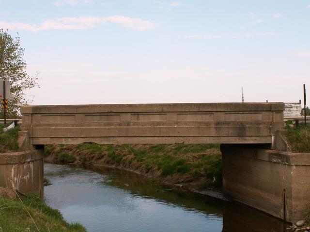
This was one of the finest examples of Michigan's standard plan concrete girder bridges. The girders had survived the assault of salt well, and were in excellent condition. The only area of trouble was the deck, which had some damage which was most likely due to salt. Michigan's historic bridge inventory gives a date of 1938 for the construction of this bridge. Bridges like this one were mostly built from 1914 through the 1920s. This would seem like a relatively late example of this bridge type, which could account for the good condition it is in. On the other hand, it is equally likely that the date given for the construction of the bridge is incorrect. 1928 instead of 1938 would seem more on-target.
Although among the simplest decorated of historic bridges, and nowhere near as beautiful as a truss bridge, you can still tell that care was taken is making these bridges something special.
As with most historic bridge demolitions, the demolition of this bridge represents a complete failure of our government on all levels. At the federal level, there should be money available to fund the complete restoration of a bridge like this one, such as that provided by the discriminatory National Historic Covered Bridge Act. At the state level, historic bridge inventories should have gone beyond simple suggestion of possible historic significance, and rather immediately pursued National Register of Historic Places listing for bridges such as this. Historic Bridge Programs should have been mandated by the federal government and carried out by the states. Also at the state level, no funding should be provided for the replacement of a historic bridge as was done here. This would discourage road commissions from replacing historic bridges. Funding instead should have only been for a rehabilitation project. At the county level, not enough effort is put forth to preserve these bridges. The Kent County Road Commission is moving to save the Pine Island Drive Bridge, and Midland County Road Commission is noted for preserving two bridges, North Saginaw Road and 7 Mile Road. None of St. Clair County's truss bridges or concrete girder bridges are being preserved by the county. If one county can preserve a bridge, there is no reason why another cannot. The replacement of this bridge also represents a lack of public awareness of historic bridges and their importance. Too few people are speaking out against demolition of bridges such as this, although they usually will applaud any preservation effort. Even if you do not care about history or beauty on the road, you should at least care about how your tax dollars are being spent. The replacement of this bridge is a waste of money. The restoration of this bridge would most likely have cost the same or less than replacing this bridge. The government is wasting your money, and as a citizen you should speak out to lawmakers against this. Money wasted on bridge replacement could be going towards other improvements, like road resurfacing, or to a whole different area of life, like funding for education.
If you find any of this disturbing, consider writing a letter to your lawmakers at any and all levels of government.
Consider the below findings of the bridge as listed at the time of demolition from the National Bridge Inventory.
Functional Classification: Rural Major Collector
Service On Bridge: Highway
Service Under Bridge: Waterway
Lanes On Structure: 2
Deck Condition: Fair Condition
Superstructure Condition: Fair Condition
Substructure Condition: Good Condition
Scour: Foundations determined to be stable for calculated scour
conditions
Bridge Railing: Meets currently acceptable standards.
Structural Evaluation: Meets minimum tolerable limits to be left in
place as is
Water Adequacy Evaluation: Equal to present minimum criteria
Average Daily Traffic: 1090
Year of Average Daily Traffic: 1994
Sufficiency Rating: 40.1 %
In particular, note the condition of the bridge which was all fair or better. This was not a bridge to replace, it was a bridge to repair. Even the county might have admitted this, but only after telling you that they had to replace it to get money from the state. This is the sort of policy that needs to be revised.
This bridge is tagged with the following special condition(s): Unorganized Photos
![]()
![]()
![]()
![]()
This historic bridge has been demolished. This map is shown for reference purposes only.
Coordinates (Latitude, Longitude):
Search For Additional Bridge Listings:
Bridgehunter.com: View listed bridges within 0.5 miles (0.8 kilometers) of this bridge.
Bridgehunter.com: View listed bridges within 10 miles (16 kilometers) of this bridge.
Additional Maps:
Google Streetview (If Available)
GeoHack (Additional Links and Coordinates)
Apple Maps (Via DuckDuckGo Search)
Apple Maps (Apple devices only)
Android: Open Location In Your Map or GPS App
Flickr Gallery (Find Nearby Photos)
Wikimedia Commons (Find Nearby Photos)
Directions Via Sygic For Android
Directions Via Sygic For iOS and Android Dolphin Browser
USGS National Map (United States Only)
Historical USGS Topo Maps (United States Only)
Historic Aerials (United States Only)
CalTopo Maps (United States Only)

© Copyright 2003-2024, HistoricBridges.org. All Rights Reserved. Disclaimer: HistoricBridges.org is a volunteer group of private citizens. HistoricBridges.org is NOT a government agency, does not represent or work with any governmental agencies, nor is it in any way associated with any government agency or any non-profit organization. While we strive for accuracy in our factual content, HistoricBridges.org offers no guarantee of accuracy. Information is provided "as is" without warranty of any kind, either expressed or implied. Information could include technical inaccuracies or errors of omission. Opinions and commentary are the opinions of the respective HistoricBridges.org member who made them and do not necessarily represent the views of anyone else, including any outside photographers whose images may appear on the page in which the commentary appears. HistoricBridges.org does not bear any responsibility for any consequences resulting from the use of this or any other HistoricBridges.org information. Owners and users of bridges have the responsibility of correctly following all applicable laws, rules, and regulations, regardless of any HistoricBridges.org information.
![]()