We Recommend:
Bach Steel - Experts at historic truss bridge restoration.
Pine Island Drive Bridge

Primary Photographer(s): Nathan Holth and Rick McOmber
Bridge Documented: December 2005 and July-September 2014
Rural: Kent County, Michigan: United States
1924 By Builder/Contractor: Peter Brill of Vriesland, Michigan and Engineer/Design: Michigan State Highway Department
2014
92.3 Feet (28.1 Meters)
100.0 Feet (30.5 Meters)
20 Feet (6.1 Meters)
1 Main Span(s)
41200081000B010

View Information About HSR Ratings
Bridge Documentation
View Archived National Bridge Inventory Report - Has Additional Details and Evaluation
Learn about Michigan's Unique Concrete Camelback Bridges
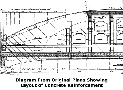
View The Original Plans, Rehabilitation Plans, and Rehabilitation Contract Proposal for this historic bridge.

An Outstanding Rehabilitation
As of September 2014, Kent County Road Commission has completed a rehabilitation and cleaning of this historic bridge. Kent County deserves a big thank you for choosing to preserve this unique bridge which is unlike anything else in the state! The preservation of this structure is a role model for the rest of the state. The rehabilitation of this bridge was undertaken in a very sensitive manner, and the original design, materials, and appearance of the bridge was not changed during rehabilitation. Additionally, the deck was repaired with a new concrete wearing surface, while the previous asphalt wearing surface was removed. This was particularly noteworthy since asphalt overlays on historic concrete bridge decks tend to trap moisture and contribute to deck deterioration.

About This Unique and Beautiful Historic Bridge
This is a one-of-a-kind example of a bridge that is essentially a custom-designed adaptation of Michigan's unique concrete camelback bridges into a 100 foot span. It is unique to Michigan and indeed the entire country.
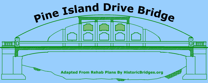
Michigan developed state standard plans for a concrete curved chord through girder bridges (often called concrete camelback bridges) of a variety of span lengths from 40-90 feet. No standard was developed for a 100 foot span however. It was originally proposed to build a truss bridge at this location, but that idea was rejected by the county who did not want a metal truss bridge, and instead this concrete bridge was built. Since the standard camelback plans did not offer a 100 foot span, one had to be custom-designed. This can be seen in the unique details of the bridge. At the same time, the architectural details of the bridge, such as the pierced openings in the girder, use of inset patterns in the girder, and the approach balustrade railing, bring to mind the general details of the standard plans.
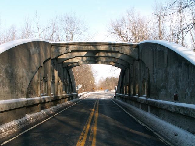
Because it does not conform to a standard plan and is the only one of its kind ever built, the bridge is unique in Michigan. Because most other states did not build concrete camelback bridges, and those that did utilized different architectural details and rarely built spans over 60 feet, the bridge is also unique on a national level. Its curved design gives the bridge a graceful appearance, its extensive architectural detailing adds to the beauty of the bridge, and its size (which far exceeds the typical economical span size for a bridge of this type) is by necessity very massive giving the bridge a strong visual feeling of strength. The bridge is also noted for its overhead bracing, not used in any other concrete camelback bridge.
This bridge was really spruced up with architectural details. One could almost call the bridge ornate. The pierced openings are not just simple holes, they have a keyhole-like shape to them. Above the openings, inset, but not pierced, designs are identical to accent the piercing below. End posts on the bridge have inset rectangular designs. The overhead bracing has been shaped to give the appearance that it sits on brackets. Looking up at this bracing on the bridge, you can see that the bracing has had its interior corners rounded to give it a window-like appearance. The unique design and excellent historic integrity (no alterations) of this bridge makes it one of the most historically significant concrete bridges in Michigan. It can be thought of as the king of concrete camelback bridges!

Above: This photo shows the previous Pine Island Drive Bridge, a Pratt pony truss bridge with pinned connections. It appears to be under replacement in this photo, in preparation for the concrete bridge's construction.
![]()
Photo Galleries and Videos: Pine Island Drive Bridge
2014 Bridge Photo-Documentation
Original / Full Size PhotosA collection of overview and detail photos showing the bridge during rehabilitation, and shortly after completion. This gallery offers photos in the highest available resolution and file size in a touch-friendly popup viewer.
Alternatively, Browse Without Using Viewer
![]()
2014 Bridge Photo-Documentation
Mobile Optimized PhotosA collection of overview and detail photos showing the bridge during rehabilitation, and shortly after completion This gallery features data-friendly, fast-loading photos in a touch-friendly popup viewer.
Alternatively, Browse Without Using Viewer
![]()
Pre-Rehab Bridge Photo-Documentation
A collection of overview and detail photos taken before the 2014 bridge rehabilitation. This photo gallery contains a combination of Original Size photos and Mobile Optimized photos in a touch-friendly popup viewer.Alternatively, Browse Without Using Viewer
![]()
Maps and Links: Pine Island Drive Bridge
Coordinates (Latitude, Longitude):
Search For Additional Bridge Listings:
Bridgehunter.com: View listed bridges within 0.5 miles (0.8 kilometers) of this bridge.
Bridgehunter.com: View listed bridges within 10 miles (16 kilometers) of this bridge.
Additional Maps:
Google Streetview (If Available)
GeoHack (Additional Links and Coordinates)
Apple Maps (Via DuckDuckGo Search)
Apple Maps (Apple devices only)
Android: Open Location In Your Map or GPS App
Flickr Gallery (Find Nearby Photos)
Wikimedia Commons (Find Nearby Photos)
Directions Via Sygic For Android
Directions Via Sygic For iOS and Android Dolphin Browser
USGS National Map (United States Only)
Historical USGS Topo Maps (United States Only)
Historic Aerials (United States Only)
CalTopo Maps (United States Only)


