

View Information About HSR Ratings
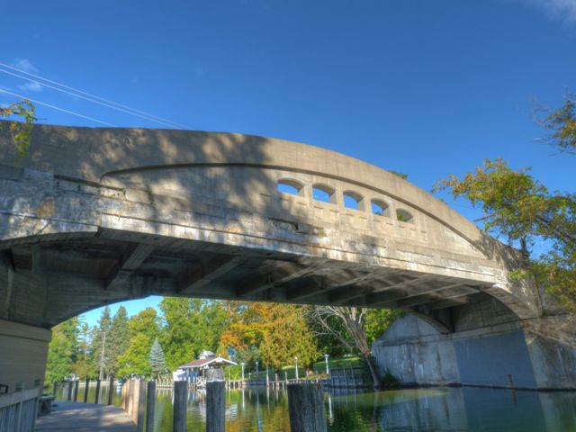
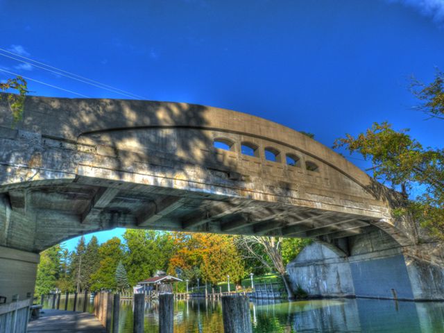
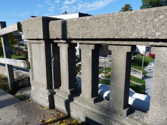
This bridge was a beautiful example of Michigan's breathtaking 90 foot plan of a concrete curved chord through girder. The Indian River Bridge was a particularly rare example of one with a sidewalk included as part of the original structure. Only one other such bridge survives in the entire state. This is because concrete camelback bridge types were usually rural bridges and so sidewalks were not normally included. Today, the only remaining bridge that includes a sidewalk is the Okemos Road Bridge. Although not a historically or technologically significant detail, the Indian River Bridge was further unusual because it shared an abutment with a parallel railroad bridge which is only used for non-motorized traffic and is no longer part of an active railroad line.
Although today a county road, the roadway this bridge was on was originally US-27. As such, the bridge had Trunk Line Bridge plaques on it, which credited J.B. Whitcomb Construction Company with building the bridge.
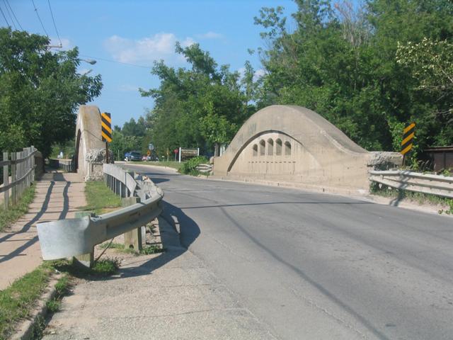
This is a historic bridge that was extremely easy to visit and was not out of the way hardly at all. Anyone traveling up to the U.P. on I-75 could get off at Exit 310, turn right at the Straits Highway junction, and head north. You would drive right over the bridge, and could continue north and get right back on the expressway, at exit 313. There would be fast food and other services available in Indian River, so it made an all-around great place to make a short stop on a trip up north. Today however, Indian River offers no historic bridge to anyone who decides to take a break from a drive on I-75. There is no longer any particular incentive for I-75 travelers to exit at Indian River versus any number of exits that offer typical food, gas, etc.
The Cheboygan County Road Commission made the decision to reduce the Indian River Bridge into nothing but memories. HistoricBridges.org is proud to offer a number of photo galleries that seek to document this bridge. Tuscarora Township also set up a unique community photo on the bridge shortly before demolition to replicate a historical photo taken in 1933. Tuscarora Township has been kind enough to make these photos available for viewing on HistoricBridges.org as seen below. In addition, artist Sandra Strohschein has created two paintings of the bridge. These paintings and prints can be purchased online. Click on the images appearing in this narrative.
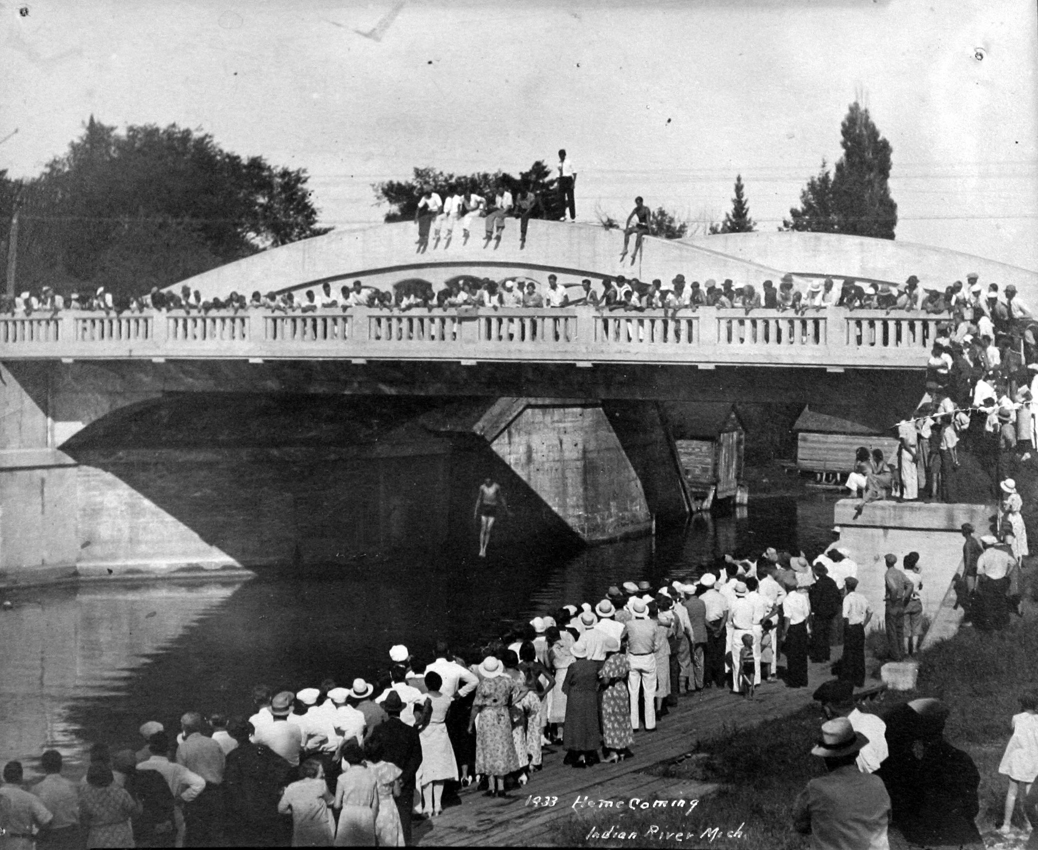 Historical Photo Showing The 1933 Homecoming On The Bridge Photo Provided Courtesy Jane E. McGinnis, Tuscarora Township |
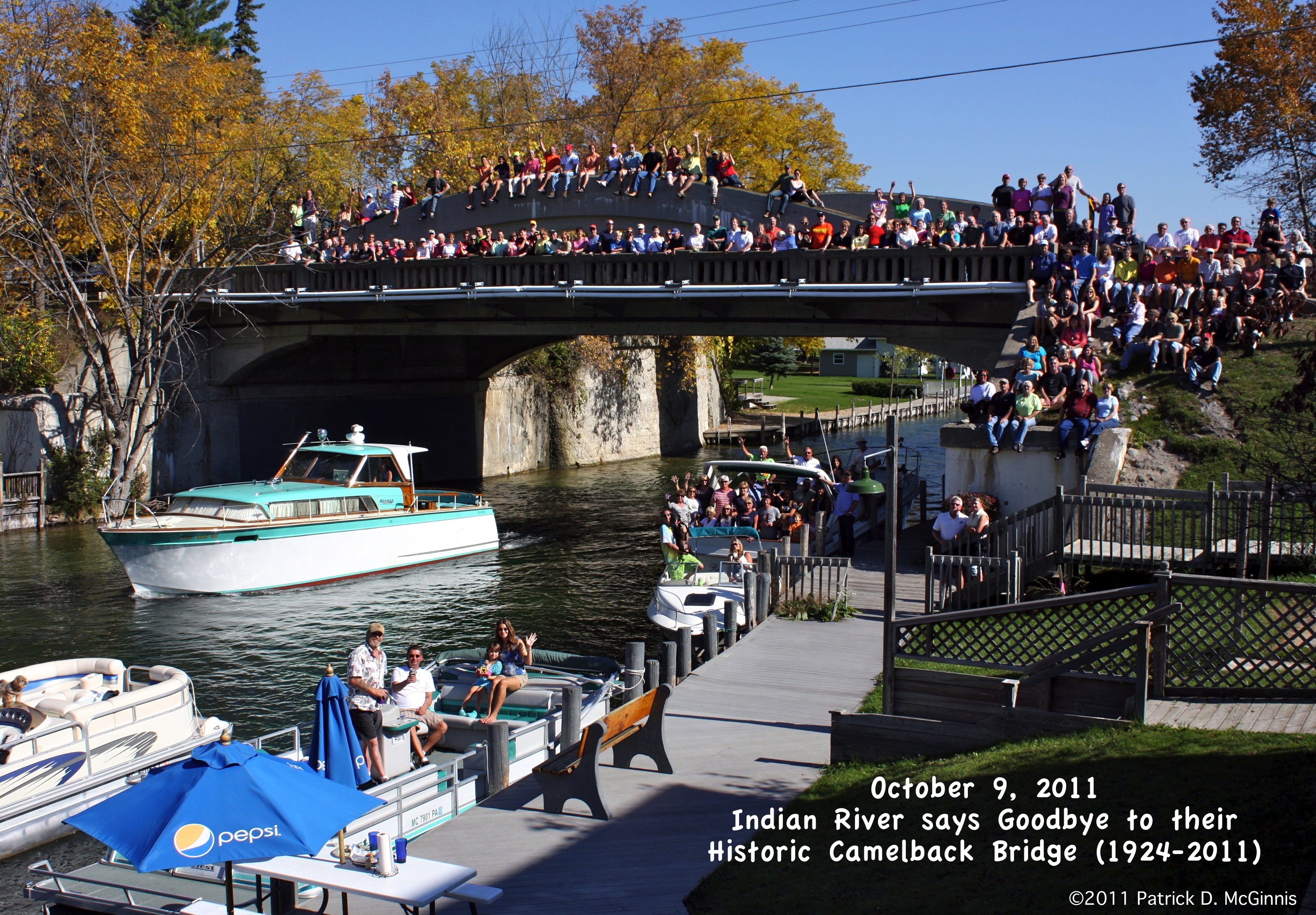 2011 Photo Community Photo On Bridge Prior To Demolition Photo Provided Courtesy Jane E. McGinnis, Tuscarora Township |
Cheboygan County Road Commission chose to demolish this beautiful historic bridge and replace it with a bridge that is little more in appearance and design than a slab of concrete. The county has attempted to make the replacement structure look less ugly than it really is by attaching superficial decoration. These decorations include a modified design of Michigan's "aesthetic parapet tube" (MDOT's name, not HistoricBridges.org's) type of guardrail, and the use of stone form-liners in the abutment to make the abutments look like stone. Taking an ugly bridge and simply attaching decorations to it with the goal of making it look beautiful goes against modern thinking of what constitutes aesthetic bridge design. The historic Indian River Bridge was actually a somewhat early example of a bridge that did embody modern thinking on aesthetic bridge design, which focuses on having beauty derived from the functioning structure of the bridge itself, not through superficial ornamentation. This was evidenced by the graceful curved girders which were part of the functioning structure. Even the pierced openings in the girders would have served to reduce the dead load of the bridge.
The only apparent reason for demolishing this historic bridge was the narrow deck width of the bridge. This being the case, HistoricBridges.org strongly believes that constructing a one-lane bridge next to the historic bridge to form a one-way couplet would have been a viable preservation alternative.
Another alternative would have been to remove the railroad plate girder bridge (which although old is not very significant historically) and to jack up and slide the girder bridge over to where the plate girder is located, so that it could remain in use for non-motorized traffic. The two-lane vehicular bridge could have then be built on the former footprint of the historic bridge, without requiring demolition of the historic bridge. Although undesirable, a compromise to help these two wider structures fit side by side might have been to remove the sidewalk on the curved chord through girder. Although this would mean the loss of a historically significant detail, the remaining 90 foot girder would still remain an extremely significant and beautiful historic bridge.
Another possible alternative would have been simply be to rehabilitate the historic bridge for continued two-lane vehicular use. It is doubtful that speed limits need to be very high in the urban setting where this bridge was located, and reduced speed limits could have compensated for the narrow deck width. In addition, trucks could have been restricted from using the bridge. Nearby I-75 which parallels Straits Highway and has exits for Straits Highway both north and south of the bridge only a mile or two can serve as an alternative route of over-width vehicles.

Michigan is known for its unique concrete curved chord though girder bridges (commonly called concrete camelback bridges) such as this one. A few other states built curved chord through girder bridges, but none of these other states included plans for bridges that exceeded much beyond 60 feet in length. Michigan however included plans for spans up to 90 feet, which the Indian River Bridge is an example of. Fully 30 feet beyond the traditional 60 foot limit for concrete through girders, Michigan's 90 foot plan curved chord through girders demonstrate the practical limits of the technology and are thus technologically significant as noteworthy engineering achievements. The bridges are also known for being some of the most over-built bridges ever encountered. The deck of a 70 foot concrete camelback bridge in Michigan (that was in good condition when demolished) was found to have capacity to hold an excavator after the load-bearing girders had been demolished! This was because the contractors demolishing the bridge apparently thought the girders were just for looks and did not understand that they were a load-bearing part of the bridge.
Only Ohio comes near to Michigan's population of curved chord through girder examples which in 2005 was around 40 examples (and none longer than about 60 feet), although both Michigan's and Ohio's population is dropping at an alarming rate. Even though 40 bridges is about as many examples as any state has, it is a tiny percentage of bridges, and is less than half as large as Michigan's modest truss bridge population. To make matters even more serious, Michigan's 90 foot plan examples like the Indian River Bridge, which are the most historically and technologically significant of the camelbacks make up only a small percentage of the total examples in Michigan. As such, the preservation of each surviving example should be considered significant, and each surviving example should be recognized as an extremely significant historic bridge in Michigan.
At the minimum, the first step moving forward would be for Michigan to formally list all 90 foot concrete camelbacks (and indeed if possible, all surviving concrete camelbacks of all sizes) in the National Register of Historic Places by completing a Multiple Property Submission. Listing bridges in the National Register tends to increase public awareness and tends to improve the press coverage that historic bridges get. Further, if any federal funding for replacing any of the bridges is involved, it requires Section 106 to take place. It also allows Transportation Enhancement Grants to be applied to the bridges for preservation solutions for non-motorized use.
Another logical step would be to develop a statewide Concrete Camelback Bridge Management Plan, similar to historic bridge management plans developed by other states. The goal of the management plan would be to evaluate each surviving concrete camelback bridge and determine what preservation solution is most appropriate and feasible for each bridge.
![]()
![]()
![]()
![]()
![]()
![]()

![]()
![]()

![]()
![]()
![]()
![]()
This historic bridge has been demolished. This map is shown for reference purposes only.
Coordinates (Latitude, Longitude):
Search For Additional Bridge Listings:
Bridgehunter.com: View listed bridges within 0.5 miles (0.8 kilometers) of this bridge.
Bridgehunter.com: View listed bridges within 10 miles (16 kilometers) of this bridge.
Additional Maps:
Google Streetview (If Available)
GeoHack (Additional Links and Coordinates)
Apple Maps (Via DuckDuckGo Search)
Apple Maps (Apple devices only)
Android: Open Location In Your Map or GPS App
Flickr Gallery (Find Nearby Photos)
Wikimedia Commons (Find Nearby Photos)
Directions Via Sygic For Android
Directions Via Sygic For iOS and Android Dolphin Browser
USGS National Map (United States Only)
Historical USGS Topo Maps (United States Only)
Historic Aerials (United States Only)
CalTopo Maps (United States Only)

© Copyright 2003-2024, HistoricBridges.org. All Rights Reserved. Disclaimer: HistoricBridges.org is a volunteer group of private citizens. HistoricBridges.org is NOT a government agency, does not represent or work with any governmental agencies, nor is it in any way associated with any government agency or any non-profit organization. While we strive for accuracy in our factual content, HistoricBridges.org offers no guarantee of accuracy. Information is provided "as is" without warranty of any kind, either expressed or implied. Information could include technical inaccuracies or errors of omission. Opinions and commentary are the opinions of the respective HistoricBridges.org member who made them and do not necessarily represent the views of anyone else, including any outside photographers whose images may appear on the page in which the commentary appears. HistoricBridges.org does not bear any responsibility for any consequences resulting from the use of this or any other HistoricBridges.org information. Owners and users of bridges have the responsibility of correctly following all applicable laws, rules, and regulations, regardless of any HistoricBridges.org information.
![]()