We Recommend:
Bach Steel - Experts at historic truss bridge restoration.
BridgeHunter.com Phase 1 is released to the public! - Visit Now
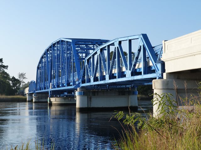
US-17 St. Marys River Bridge

Primary Photographer(s): Nathan Holth
Bridge Documented: November 15, 2014
Rural: Nassau County, Florida and Camden County, Georgia: United States
Metal 12 Panel Rivet-Connected Polygonal Warren Through Truss, Movable: Swing (Center Bearing Center Pier) and Approach Spans: Metal 8 Panel Rivet-Connected Polygonal Warren Pony Truss, Fixed
1927 By Builder/Contractor: Virginia Bridge and Iron Company of Roanoke, Virginia
2005
202.0 Feet (61.6 Meters)
562.0 Feet (171.3 Meters)
19.7 Feet (6 Meters)
1 Main Span(s) and 8 Approach Span(s)
740008

View Information About HSR Ratings
Bridge Documentation
View Archived National Bridge Inventory Report - Has Additional Details and Evaluation
View Historic Bridge Inventory Sheet For This Bridge
This bridge is an attractive, impressive, and regionally rare example of a through truss swing bridge. At either end of the swing span is a pony truss approach span. Additional approach spans are concrete t-beam spans.
The Pensacola Shipbuilding Company of Pensacola, Florida was the contractor for the bridge. Virginia Bridge and Iron Company fabricated and erected the trusses, while A. Bentley and Sons of Toledo, Ohio erected the substructure and approaches. Learn about A. Bentley and Sons of Toledo, Ohio on another bridge's page.
US-17 and this bridge were part of the main federal highway into Florida for travelers from the Northeastern United States when first built. Therefore, this bridge is significant as part of an early alignment of a major travel corridor that has a major economic effect on Florida. I-95 serves the purpose of US-17 today.
The bridge was rehabilitated in 2005. A lot of rivets were replaced with bolts including as part of member strengthening in some areas. At the same time, it was interesting to note that a couple isolated areas of complete section loss were not repaired and were simply painted over. Overall however, the bridge is a good example of a rehabilitated historic truss bridge. The bridge's hand-turned movable components appear to be maintained in working condition, and new equipment (likely dating to the 2005 rehabilitation) for greasing rollers and bearings were observed, suggesting the bridge can still be operated. At the same time, it is questionable whether the bridge ever does operate. If it does, it would be a major operation requiring temporary barricades since there are no gates at the ends of the bridge.
Be sure to view the extensive photo gallery for this bridge which includes detail photos of all mechanical components on the swing pier.
![]()
Photo Galleries and Videos: US-17 St. Marys River Bridge
Bridge Photo-Documentation
Original / Full Size PhotosA collection of overview and detail photos. This gallery offers photos in the highest available resolution and file size in a touch-friendly popup viewer.
Alternatively, Browse Without Using Viewer
![]()
Bridge Photo-Documentation
Mobile Optimized PhotosA collection of overview and detail photos. This gallery features data-friendly, fast-loading photos in a touch-friendly popup viewer.
Alternatively, Browse Without Using Viewer
![]()
CarCam: Northbound Crossing
Full Motion VideoNote: The downloadable high quality version of this video (available on the video page) is well worth the download since it offers excellent 1080 HD detail and is vastly more impressive than the compressed streaming video. Streaming video of the bridge. Also includes a higher quality downloadable video for greater clarity or offline viewing.
![]()
CarCam: Southbound Crossing
Full Motion VideoNote: The downloadable high quality version of this video (available on the video page) is well worth the download since it offers excellent 1080 HD detail and is vastly more impressive than the compressed streaming video. Streaming video of the bridge. Also includes a higher quality downloadable video for greater clarity or offline viewing.
![]()
Maps and Links: US-17 St. Marys River Bridge
Coordinates (Latitude, Longitude):
Search For Additional Bridge Listings:
Bridgehunter.com: View listed bridges within 0.5 miles (0.8 kilometers) of this bridge.
Bridgehunter.com: View listed bridges within 10 miles (16 kilometers) of this bridge.
Additional Maps:
Google Streetview (If Available)
GeoHack (Additional Links and Coordinates)
Apple Maps (Via DuckDuckGo Search)
Apple Maps (Apple devices only)
Android: Open Location In Your Map or GPS App
Flickr Gallery (Find Nearby Photos)
Wikimedia Commons (Find Nearby Photos)
Directions Via Sygic For Android
Directions Via Sygic For iOS and Android Dolphin Browser
USGS National Map (United States Only)
Historical USGS Topo Maps (United States Only)
Historic Aerials (United States Only)
CalTopo Maps (United States Only)


