

View Information About HSR Ratings
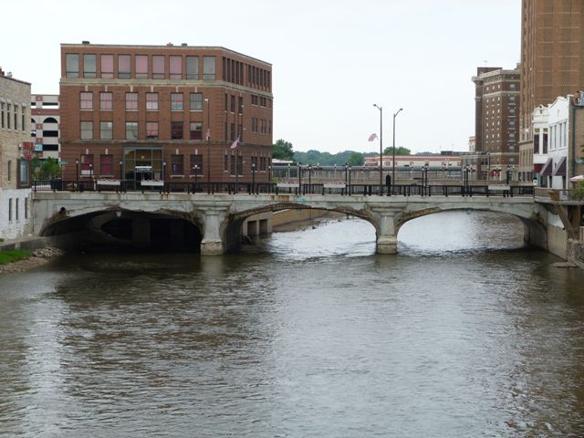
This bridge is composed of three spans, but if viewed from Galena Boulevard, the bridge looks like a two-span bridge because an adjacent building sits right next to one of the spans. The two Downer Place bridges suffer from severe spalling of the exterior concrete. It is hoped that they will be rehabilitated with attention paid to maintaining and restoring the original architectural details of the bridges.
Aurora is a unique city in that a significant portion of its main downtown area is located on an island (called Stolp Island) and this island is connected by four roads which connect to this island from each side of the river. From north to south these are New York Street, Galena Boulevard, Downer Place, and Benton Street. This results in a total of eight bridges, although New York Street is technically a single bridge whose center portion was buried when the island was expanded northward in the 1960s. Amazingly, as of 2011, all bridges connecting to Stolp Island were historic concrete arch bridges, an impressive quantity of bridges to stand as a group of historic bridges that are undisturbed by any demolition and replacement projects. Each road has its own unique style of bridge, for a total of four different general bridge designs. All bridges contribute to a National Register of Historic Places Historic District. The physical condition and historic integrity of each of the bridges varies, however despite any alterations this is a very unique and highly significant group of bridges that makes Aurora an excellent one-stop destination to get a good sampling of concrete arch bridges. Even better, a few additional arch bridges are located a short distance south of Stolp Island at Hurds Island Park.
![]()
![]()
![]()
This historic bridge has been demolished. This map is shown for reference purposes only.
Coordinates (Latitude, Longitude):
Search For Additional Bridge Listings:
Bridgehunter.com: View listed bridges within 0.5 miles (0.8 kilometers) of this bridge.
Bridgehunter.com: View listed bridges within 10 miles (16 kilometers) of this bridge.
Additional Maps:
Google Streetview (If Available)
GeoHack (Additional Links and Coordinates)
Apple Maps (Via DuckDuckGo Search)
Apple Maps (Apple devices only)
Android: Open Location In Your Map or GPS App
Flickr Gallery (Find Nearby Photos)
Wikimedia Commons (Find Nearby Photos)
Directions Via Sygic For Android
Directions Via Sygic For iOS and Android Dolphin Browser
USGS National Map (United States Only)
Historical USGS Topo Maps (United States Only)
Historic Aerials (United States Only)
CalTopo Maps (United States Only)

© Copyright 2003-2024, HistoricBridges.org. All Rights Reserved. Disclaimer: HistoricBridges.org is a volunteer group of private citizens. HistoricBridges.org is NOT a government agency, does not represent or work with any governmental agencies, nor is it in any way associated with any government agency or any non-profit organization. While we strive for accuracy in our factual content, HistoricBridges.org offers no guarantee of accuracy. Information is provided "as is" without warranty of any kind, either expressed or implied. Information could include technical inaccuracies or errors of omission. Opinions and commentary are the opinions of the respective HistoricBridges.org member who made them and do not necessarily represent the views of anyone else, including any outside photographers whose images may appear on the page in which the commentary appears. HistoricBridges.org does not bear any responsibility for any consequences resulting from the use of this or any other HistoricBridges.org information. Owners and users of bridges have the responsibility of correctly following all applicable laws, rules, and regulations, regardless of any HistoricBridges.org information.
![]()