


View Information About HSR Ratings
This bridge is easily the most historically significant truss bridge remaining in Iroquois County (keep in mind the Sugar Creek Chapel Bridge is an arch). On a statewide, and even nationally, this bridge is one of the best and most significant examples of its type. This bridge consists of three spans, each of a different design. Two of the spans are approach spans. The main span of the bridge has the greatest significance, as a bedstead truss bridge that with a ca. 1885 construction date is a very old example of its type. The bedstead span also is unaltered, which adds to its significance. The western approach span is also highly significant in its own right, as a rare example of a distinctive design of lightweight double-intersection Warren pony truss that was used in the early 20th century, presumably built ca. 1904, based on a date listed in the National Bridge Inventory. The eastern approach span is a simple steel stringer span and is not comparatively noteworthy. 1904 was the date listed in the inventory for the construction date of this bridge. The bedstead portion of the bridge, bearing the name of the Smith Bridge Company, must be older than that. The Smith Bridge Company became known as the Toledo Bridge Company in 1890.
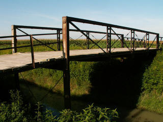
First, an overview of the bedstead truss. The bedstead truss bridge (sometimes called a truss leg bridge) was an economical type of bridge, marketed for its inexpensive design. By using vertical endposts that extended below the bottom chord, the end posts also doubled as supports for the bridge. The result is that a much smaller abutment was needed for the bridge, which significantly reduced costs. This seemed like a good idea, but it turned out to have a major problem. The relatively slender truss supports which often extended into the flood levels of the water, were extremely vulnerable to debris from any floods that occurred. The truss posts could be bent, which greatly weakened the strength of the supports. As such, the design didn't stay popular as long as other truss bridge types, and worse, the damage done to these bridges by the floods undoubtedly put them up for replacement by their owners much sooner and more often than other truss bridge types. The result is that today this bridge type is extremely rare. Surviving examples are highly significant.
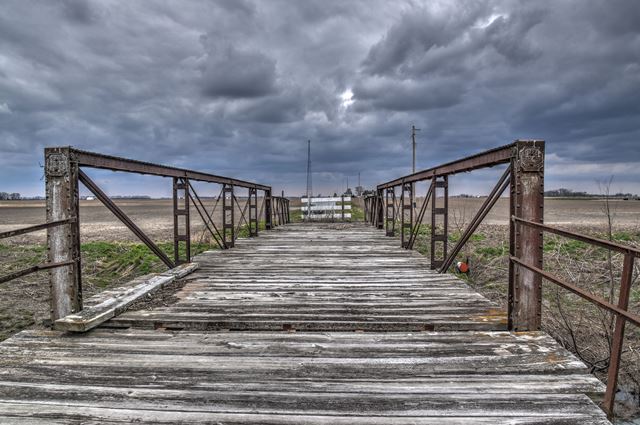
This Iroquois County example is as a result an example of a rare structure type. As a four panel structure it is also a fairly large example of the type, since bedstead truss bridges generally were rather short structures. Also, this bridge is a rather impressive and visual example of the bedstead design, since the truss supports are very long and visible, and so the layout and design of the bedstead is made quite clear. The bridge features pinned connections and a wooden deck. There are no railings on the bridge. There may have been no railings ever. On the other hand, the eastern stringer approach span has some simple metal railings, which perhaps were on the bedstead span also at one time.
The bedstead span retains builder plaques crediting the Smith Bridge Company of Toledo, Ohio with building the bridge, although the plaques unfortunately are a design that didn't feature a date. One unusual design feature of the bridge is that there is no v-lacing or lattice on the bridge's built-up members and chords. Instead, on the verticals, battens are used. Smith Bridge Company preferred the battens for its bridges, compared to other companies that used v-lacing or lattice.
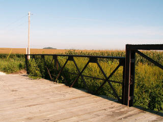
The lightweight pony truss approach span is similar to the Michigan's Powers Highway Bridge. In fact the basic design of the bridges are essentially identical. A small number of similar bridges can be found elsewhere in the country as well. These distinctive bridges are double-intersection Warren pony trusses distinguished by riveted connections, extremely lightweight members and chords, and vertical end posts. This lightweight style of truss was marketed to counties and townships as a low-cost alternative to heavier, more common truss bridge styles of the period. These lightweight bridges were functional for the needs of lightly traveled rural roads. Surviving examples are significant as a distinctive truss style dissimilar to the more massive truss bridges that were more common during this period.
This bridge should receive a high priority for preservation. When HistoricBridges.org documented Iroquois County's historic truss bridges in 2006, many bridges listed were found to have been replaced. Since 2006, a disturbing additional number of truss bridges have been demolished and replaced. As of 2013, this bridge apparently still remains, but is now listed as closed to traffic. HistoricBridges.org sincerely hopes that this bridge will not be demolished. It would be a devastating loss if it was.
This bridge is tagged with the following special condition(s): Unorganized Photos
![]()
![]()
![]()
![]()
![]()
Coordinates (Latitude, Longitude):
Search For Additional Bridge Listings:
Bridgehunter.com: View listed bridges within 0.5 miles (0.8 kilometers) of this bridge.
Bridgehunter.com: View listed bridges within 10 miles (16 kilometers) of this bridge.
Additional Maps:
Google Streetview (If Available)
GeoHack (Additional Links and Coordinates)
Apple Maps (Via DuckDuckGo Search)
Apple Maps (Apple devices only)
Android: Open Location In Your Map or GPS App
Flickr Gallery (Find Nearby Photos)
Wikimedia Commons (Find Nearby Photos)
Directions Via Sygic For Android
Directions Via Sygic For iOS and Android Dolphin Browser
USGS National Map (United States Only)
Historical USGS Topo Maps (United States Only)
Historic Aerials (United States Only)
CalTopo Maps (United States Only)

© Copyright 2003-2024, HistoricBridges.org. All Rights Reserved. Disclaimer: HistoricBridges.org is a volunteer group of private citizens. HistoricBridges.org is NOT a government agency, does not represent or work with any governmental agencies, nor is it in any way associated with any government agency or any non-profit organization. While we strive for accuracy in our factual content, HistoricBridges.org offers no guarantee of accuracy. Information is provided "as is" without warranty of any kind, either expressed or implied. Information could include technical inaccuracies or errors of omission. Opinions and commentary are the opinions of the respective HistoricBridges.org member who made them and do not necessarily represent the views of anyone else, including any outside photographers whose images may appear on the page in which the commentary appears. HistoricBridges.org does not bear any responsibility for any consequences resulting from the use of this or any other HistoricBridges.org information. Owners and users of bridges have the responsibility of correctly following all applicable laws, rules, and regulations, regardless of any HistoricBridges.org information.
![]()