We Recommend:
Bach Steel - Experts at historic truss bridge restoration.
Cherry Avenue Bridge
Bridge Number Z-2
Primary Photographer(s): Nathan Holth
Bridge Documented: August 12, 2006, September 12, 2011, and April-August 2013
Railroad (Baltimore and Ohio Chicago Terminal Railroad) and Non-Motorized Walkway Over North Branch Chicago River
Chicago: Cook County, Illinois: United States
1902 By Builder/Contractor: Wisconsin Bridge and Iron Company of Milwaukee, Wisconsin
2009
120.0 Feet (36.6 Meters)
230.0 Feet (70.1 Meters)
Not Available
1 Main Span(s)
Not Applicable

View Information About HSR Ratings
Bridge Documentation
View Historic American Engineering Record (HAER) Documentation For This Bridge
HAER Drawings, PDF - HAER Data Pages, HTM - HAER Data Pages, PDF
View A Historical Article Discussing This Bridge
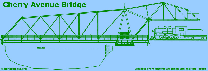
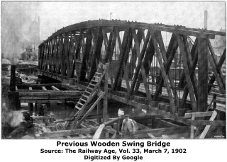
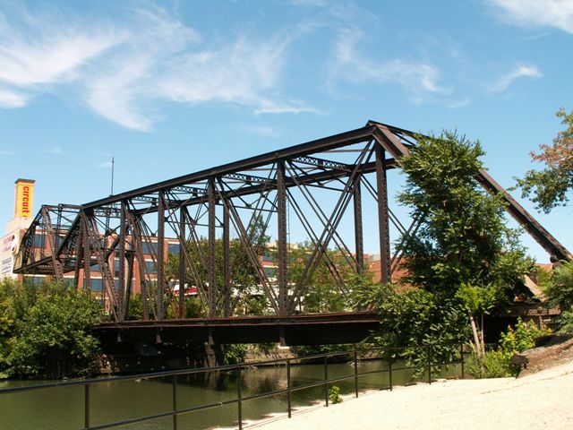
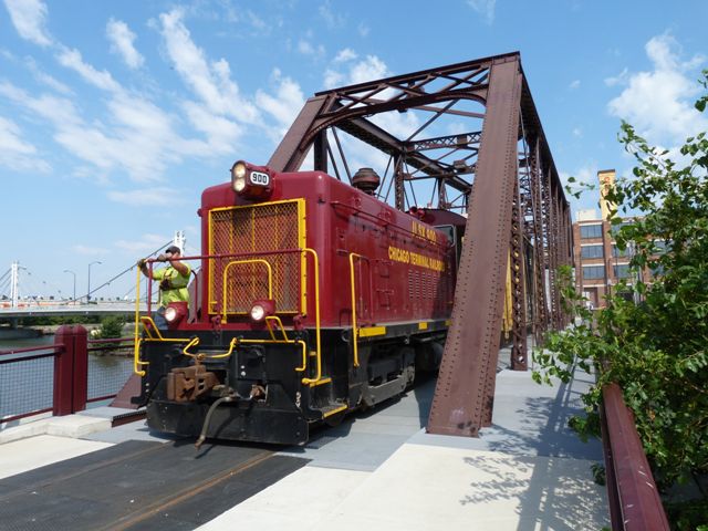
The bridge is a rare asymmetrical "bobtail" type of swing bridge. The pier is on the north side, and a concrete counterweight overhead at that end balances the structure out. This bridge was one of the first movable bridges to use concrete as a counterweight. The bridge was important to the development of Goose Island, since it was the only railroad connection to the island. The bridge was designed and operated by the Chicago, Milwaukee, and St. Paul Railroad. In its later years, the bridge would become the property of Canadian Pacific Railroad. The bridge was then bought by the Chicago Terminal Railroad, who continued to run a train across the bridge on Tuesdays and Thursdays and other days as needed. The bridge is pin connected and carries a single set of tracks. Given its rare design, it is among the most significant of Chicago's vast collection of historic bridges.
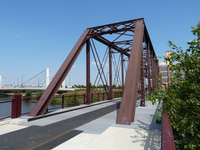
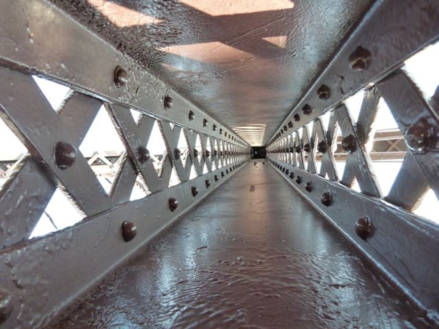
In 2009, this bridge remained in use by a very infrequent number of trains whose only purpose was to provide a connection to railroad mainlines elsewhere. As such, the potential existed to make this extremely important historic bridge both accessible and functional for the general public. As a result, a unique project was developed to restore this bridge and adapt it to support non-motorized traffic while also maintaining the ability for the bridge to carry those rare trains. Because the trains are infrequent on the bridge and not operated with the speed and right-of-way seen on a typical railroad line, the deck was designed so that non-motorized traffic is able to use the entire bridge deck freely and without restraint. The deck was specially designed so that the rails are flush with the deck and pedestrians and bicyclists do not trip on the rails, and even the small gap around the rails that is often seen with railroad grade crossings is eliminated in the design. The restoration of the bridge was beautifully conducted. The concrete counterweight was patched and repaired. The entire truss was cleaned and repainted, including the significant swing rollers and gear under the bridge that convey this bridge's movable past. One good aspect of the restoration that might be overlooked is the railings. First, the railings placed on the bridge are not gaudy and they do not distract from the historic bridge itself. More importantly, the railings were placed outside of the truss lines, rather than inside as is often done with railroad bridges. By placing these railings outside of the truss lines, pedestrians on the bridge enjoy an unfettered view of the bridge's truss members, and can even walk up and touch them. This allows visitors to experience the historic bridge in a way that is not possible on many railroad truss bridges that are converted for pedestrian use. This method of railing placement may not be appropriate for all bridges, but here it is a distinctly positive aspect of the restoration.
Interpretive signage was installed near the bridge as part of the project, conveying the significance of the bridge to visitors.
Overall, this bridge is an excellent example of how creativity can bring new life, function, and value to historic bridges. It is an example of the type of commitment to preserving historic bridges that Chicago has shown in the past with a number of its historic bridges, and hopefully it is a sign that this commitment is continuing.
As of 2013, the Chicago Water Taxi has installed a dock at the southwest quadrant of this bridge on Goose Island. They are operating service between Madison Street and here at the bridge and it is a great way to see this bridge while passing under a number of historic North Branch bridges on the way.

Information and Findings From Chicago Landmarks DesignationGeneral Information Address: North Cherry St., immediately South of
North Ave. (North Branch of Chicago River) This Bridge Is A Designated Chicago Landmark |
![]()
Historic Bridges of Chicago and Cook County


Chicago and Cook County are home to one of the largest collections of historic bridges in the country, and no other city in the world has more movable bridges. HistoricBridges.org is proud to offer the most extensive coverage of historic Chicago bridges on the Internet.
General Chicago / Cook County Bridge Resources
Chicago's Bridges - By Nathan Holth, author of HistoricBridges.org, this book provides a discussion of the history of Chicago's movable bridges, and includes a virtual tour discussing all movable bridges remaining in Chicago today. Despite this broad coverage, the book is presented in a compact format that is easy to take with you and carry around for reference on a visit to Chicago. The book includes dozens of full color photos. Only $9.95 U.S! ($11.95 Canadian). Order Now Direct From The Publisher! or order on Amazon.
Chicago River Bridges - By Patrick T. McBriarty, this is a great companion to Holth's book shown above. This much larger book offers an extremely in-depth exploration of Chicago's movable highway bridges, including many crossings that have not existed for many years. Order Now Direct From The Publisher! or order on Amazon.
View Historic American Engineering Record (HAER) Overview of Chicago Bascule Bridges (HAER Data Pages, PDF)
Chicago Loop Bridges - Chicago Loop Bridges is another website on the Internet that is a great companion to the HistoricBridges.org coverage of the 18 movable bridges within the Chicago Loop. This website includes additional information such as connections to popular culture, overview discussions and essays about Chicago's movable bridges, additional videos, and current news and events relating to the bridges.
Additional Online Articles and Resources - This page is a large gathering of interesting articles and resources that HistoricBridges.org has uncovered during research, but which were not specific to a particular bridge listing.
![]()
Photo Galleries and Videos: Cherry Avenue Bridge
Structure Overview
Original / Full Size PhotosA collection of overview photos that show the bridge as a whole and general areas of the bridge. This gallery offers photos in the highest available resolution and file size in a touch-friendly popup viewer.
Alternatively, Browse Without Using Viewer
![]()
Structure Details
Original / Full Size PhotosA collection of detail photos that document the parts, construction, and condition of the bridge. This gallery offers photos in the highest available resolution and file size in a touch-friendly popup viewer.
Alternatively, Browse Without Using Viewer
![]()
Structure Overview
Mobile Optimized PhotosA collection of overview photos that show the bridge as a whole and general areas of the bridge. This gallery features data-friendly, fast-loading photos in a touch-friendly popup viewer.
Alternatively, Browse Without Using Viewer
![]()
Structure Details
Mobile Optimized PhotosA collection of detail photos that document the parts, construction, and condition of the bridge. This gallery features data-friendly, fast-loading photos in a touch-friendly popup viewer.
Alternatively, Browse Without Using Viewer
![]()
2006 Bridge Photo-Documentation
Original / Full Size PhotosA collection of overview and detail photos from before the bridge restoration. This gallery offers photos in the highest available resolution and file size in a touch-friendly popup viewer.
Alternatively, Browse Without Using Viewer
![]()
2006 Bridge Photo-Documentation
Mobile Optimized PhotosA collection of overview and detail photos from before the bridge restoration. This gallery features data-friendly, fast-loading photos in a touch-friendly popup viewer.
Alternatively, Browse Without Using Viewer
![]()
Train Crossing Bridge
Full Motion VideoStreaming video of the bridge. Also includes a higher quality downloadable video for greater clarity or offline viewing.
![]()
Maps and Links: Cherry Avenue Bridge
Coordinates (Latitude, Longitude):
Search For Additional Bridge Listings:
Bridgehunter.com: View listed bridges within 0.5 miles (0.8 kilometers) of this bridge.
Bridgehunter.com: View listed bridges within 10 miles (16 kilometers) of this bridge.
Additional Maps:
Google Streetview (If Available)
GeoHack (Additional Links and Coordinates)
Apple Maps (Via DuckDuckGo Search)
Apple Maps (Apple devices only)
Android: Open Location In Your Map or GPS App
Flickr Gallery (Find Nearby Photos)
Wikimedia Commons (Find Nearby Photos)
Directions Via Sygic For Android
Directions Via Sygic For iOS and Android Dolphin Browser
USGS National Map (United States Only)
Historical USGS Topo Maps (United States Only)
Historic Aerials (United States Only)
CalTopo Maps (United States Only)

