

View Information About HSR Ratings
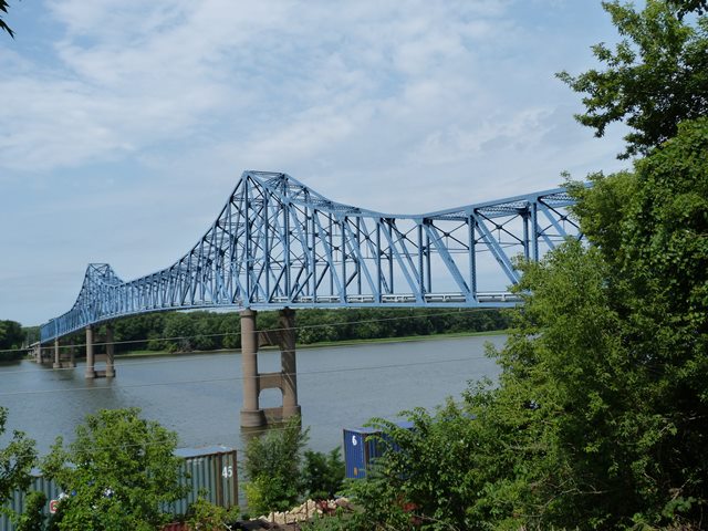
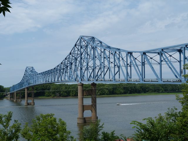
This bridge has the general appearance of a cantilever truss bridge, with its trusses that form pointy towers over the piers. However, upon closer inspection it was not apparent that any hinges were present on the bridge's main spans. As such, the bridge appears to actually function as a continuous truss. The bridge would be historically and technologically significant either way. Whether continuous or cantilevered, the bridge has a number of unusual details that distinguish it from bridges in both categories. The bridge has top chord and end posts that are composed of rolled beams rather than built-up beams. Generally the larger beams would be built-up, so this is unusual, especially considering that most of the truss vertical and diagonal members are built up. The overhead bracing also is composed of built-up beams. The built-up members include extensive v-lacing and lattice adding to the geometric beauty of the bridge. The truss configuration of the bridge is unusual. Near the towers, a rare K-truss configuration is used, however away from the towers, the configuration is a Pratt. The bridge also features a simple Pratt through truss span west of the continuous spans. West of the simple Pratt truss span is a series of steel stringer approach spans.

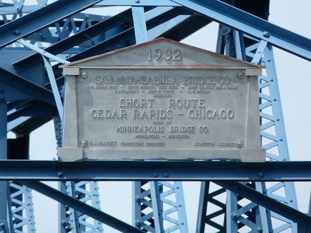
This bridge was originally built and operated as a toll bridge by the Savanna-Sabula Bridge Company. The bridge was advertised as part of a "Short Route" between Chicago and Cedar Rapids. Based on the routing of the state highway this bridge carries in Illinois, IL-64, this so-called "Short Route" would appear to refer to a route that utilizes what is known in Chicagoland as North Avenue. North Avenue is a major highway in Chicagoland, and an extremely busy street in the City of Chicago.
Large truss bridges like this are rapidly becoming rare in the United States as they are demolished and replaced with cable-stayed, steel arch, and even beam bridges. Few have been preserved. This bridge is in good physical condition. There is evidence of some section loss that occurred in the past, but this has been halted by the cleaning and repainting of the bridge. Despite this, the bridge is slated for replacement and demolition. The reason given for replacement is that the lanes on the bridge are very narrow. This is true, however demolition is not needed and indeed represents a disturbing waste of both history and tax dollars. The current plan is to replace the bridge with a new bridge on a new alignment next to the historic bridge. Because of this, the planned demolition is completely pointless. The historic bridge is not in the way of the planned replacement. The bridge would be demolished for no other reason than to needlessly reduce a landmark historic bridge to scrap metal. It is ridiculous scenarios like this that brought HistoricBridges.org into existence as a website! Another alternative that was not considered was to build a new one-lane bridge and form a one-way couplet of bridges. This would provide wide lanes for each direction of traffic, while allowing the historic bridge to continue to serve traffic.
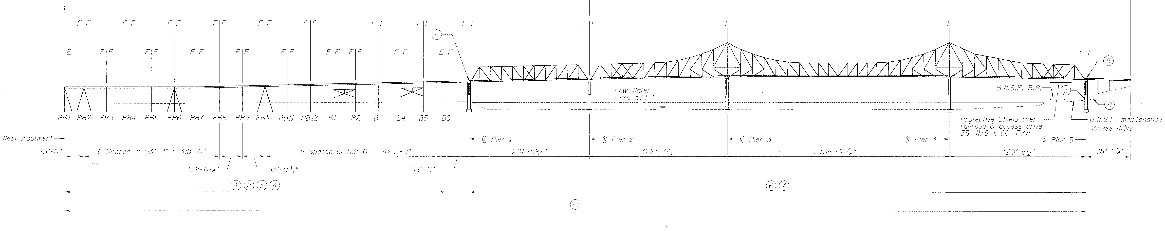
Information and Findings From Iowa's Historic Bridge InventoryDiscussion of Bridge This long-span through truss bridge crosses the Mississippi River between the riverfront town of Savanna (Illinois) and the island town of Sabula (Iowa). The main section of the Savanna-Sabula Bridge is comprised of a series of three rigid-connected through trusses, with a 520-foot, cantilevered center span flanked on both sides by 390-foot anchor spans. All are supported by spill-through concrete piers. The bridge abuts directly into the cliffs on the east side; on the west side a simply-supported, 280-foot through truss and a series of steel stringer spans form the approach. Although local citizens had been promoting the construction of a highway bridge at this location since the completion of the CM&StP Railroad bridge here in 1881, it was not until the early 1930s that the highway bridge finally began to appear feasible. The Savanna-Sabula Bridge Company was organized by local businessmen, stocks were sold in the summer 1931. The work progressed through that year and the next. The structure was opened to traffic in a dedication ceremony held on December 2, 1932. "Realizing the necessity of providing more adequate transportation facilities to keep up with the ever increasing demands of traffic," a dedication plaque states, "and desiring to stimulate still further commercial intercourse between the states of Iowa and Illinois as well as to provide for the comfort and convenience of the motor-traveling public, the citizens of the communities along this route have banded together in a common effort to turn their dreams into a reality." The Savanna-Sabula Bridge functioned for years as a toll bridge, until the stocks were eventually paid off and the structure was acquired by the states of Iowa and Illinois. Today it carries interstate traffic as a free structure, with the replacement of its deck as the only alteration of note. "Construction of the Sabula-Savanna Bridge across the Mississippi added employment in the first three years of the depression," the Iowa Writers' Project reported in 1942, "besides greatly augmenting the flow of east-west traffic through the county and thereby opening a new source of revenue--the tourist trade." Costing about $750,000, the bridge played a pivotal role in the development of transportation and commerce in the region, and for this it is historically significant. The Savanna-Sabula Bridge is technologically significant as a well-preserved example of large-scale highway truss design. Bridges over the Mississippi River comprise of some of America's longest representatives of vehicular steel truss construction, and Iowa possesses a number of notable Mississippi River bridges. Although typically configured for a structure of its scale, the Savanna-Sabula Bridge ranks among Iowa's most monumental examples of steel truss construction [adapted from Fraser 1990]. Bridge Considered Historic By Survey: Yes |
![]()
![]()
![]()
![]()
![]()

![]()
![]()
This historic bridge has been demolished. This map is shown for reference purposes only.
Coordinates (Latitude, Longitude):
Search For Additional Bridge Listings:
Bridgehunter.com: View listed bridges within 0.5 miles (0.8 kilometers) of this bridge.
Bridgehunter.com: View listed bridges within 10 miles (16 kilometers) of this bridge.
Additional Maps:
Google Streetview (If Available)
GeoHack (Additional Links and Coordinates)
Apple Maps (Via DuckDuckGo Search)
Apple Maps (Apple devices only)
Android: Open Location In Your Map or GPS App
Flickr Gallery (Find Nearby Photos)
Wikimedia Commons (Find Nearby Photos)
Directions Via Sygic For Android
Directions Via Sygic For iOS and Android Dolphin Browser
USGS National Map (United States Only)
Historical USGS Topo Maps (United States Only)
Historic Aerials (United States Only)
CalTopo Maps (United States Only)

© Copyright 2003-2024, HistoricBridges.org. All Rights Reserved. Disclaimer: HistoricBridges.org is a volunteer group of private citizens. HistoricBridges.org is NOT a government agency, does not represent or work with any governmental agencies, nor is it in any way associated with any government agency or any non-profit organization. While we strive for accuracy in our factual content, HistoricBridges.org offers no guarantee of accuracy. Information is provided "as is" without warranty of any kind, either expressed or implied. Information could include technical inaccuracies or errors of omission. Opinions and commentary are the opinions of the respective HistoricBridges.org member who made them and do not necessarily represent the views of anyone else, including any outside photographers whose images may appear on the page in which the commentary appears. HistoricBridges.org does not bear any responsibility for any consequences resulting from the use of this or any other HistoricBridges.org information. Owners and users of bridges have the responsibility of correctly following all applicable laws, rules, and regulations, regardless of any HistoricBridges.org information.
![]()