We Recommend:
Bach Steel - Experts at historic truss bridge restoration.
BridgeHunter.com Phase 1 is released to the public! - Visit Now
Base Line Road Bridge
Jackson County Bridge 189

Primary Photographer(s): Nathan Holth and Rick McOmber
Bridge Documented: May 10, 2010
Rural: Jackson County, Indiana: United States
1896 By Builder/Contractor: Lafayette Bridge Company of Lafayette, Indiana
Not Available or Not Applicable
33.8 Feet (10.3 Meters)
36.7 Feet (11.2 Meters)
15.4 Feet (4.69 Meters)
1 Main Span(s)
3600125

View Information About HSR Ratings
Bridge Documentation
View Archived National Bridge Inventory Report - Has Additional Details and Evaluation
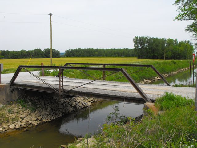
Truss bridges that are as small as this two panel bridge are very rare on today's roads. Likely, they are rare because a bridge this small does not cost a lot to replace, so a lot of examples have been lost. They would not have been built long into the 20th Century either, when steel stringers would have become efficient to roll at these lengths, making a steel stringer bridge a more preferable option for short spans. This bridge remains with good historic integrity. It is a good representative example of small-scale truss bridge construction. It is also presumed to be the construction of the Lafayette Bridge Company, a noteworthy in-state bridge builder.
HistoricBridges.org photo-documented this bridge in its original location. Later, in 2011, the bridge was preserved and relocated to the antique tractor area of the Jackson County fairgrounds. The main map page for this bridge reflects the current location of the bridge. To see the former, original location of the bridge click here.
Information and Findings From DHPA Historic Bridge SurveyStatement of Significance Pinned Warren ponies represent an early stage in the truss' development. This bridge is otherwise of standard design and retains its original members, including latticed guardrails. The northwest endpost has an I-beam brace welded to it. Architectural Description Concrete abutments and wingwalls support the single-span Warren pony truss. The pinned structure extends 35'9" in two panels. Its interior vertical is manufactured from two pairs of laced angles and its diagonals from a pair of angles. The I floor beam is U-bolted to the vertical below the lower chord and carries the concrete deck with its 15'9" roadway. Other Information Very likely a 36-foot by 16-foot bridge, on stone
abutments, constructed over Wayman Ditch by the Lafayette Bridge Company
for $221.00; the contract was let on 9 June 1896. [county research
results] Bridge Considered Historic By Survey: Yes |
![]()
Photo Galleries and Videos: Base Line Road Bridge
Bridge Photo-Documentation
Original / Full Size PhotosA collection of overview and detail photos. This gallery offers photos in the highest available resolution and file size in a touch-friendly popup viewer.
Alternatively, Browse Without Using Viewer
![]()
Bridge Photo-Documentation
Mobile Optimized PhotosA collection of overview and detail photos. This gallery features data-friendly, fast-loading photos in a touch-friendly popup viewer.
Alternatively, Browse Without Using Viewer
![]()
Maps and Links: Base Line Road Bridge
Coordinates (Latitude, Longitude):
Search For Additional Bridge Listings:
Bridgehunter.com: View listed bridges within 0.5 miles (0.8 kilometers) of this bridge.
Bridgehunter.com: View listed bridges within 10 miles (16 kilometers) of this bridge.
Additional Maps:
Google Streetview (If Available)
GeoHack (Additional Links and Coordinates)
Apple Maps (Via DuckDuckGo Search)
Apple Maps (Apple devices only)
Android: Open Location In Your Map or GPS App
Flickr Gallery (Find Nearby Photos)
Wikimedia Commons (Find Nearby Photos)
Directions Via Sygic For Android
Directions Via Sygic For iOS and Android Dolphin Browser
USGS National Map (United States Only)
Historical USGS Topo Maps (United States Only)
Historic Aerials (United States Only)
CalTopo Maps (United States Only)

