

View Information About HSR Ratings
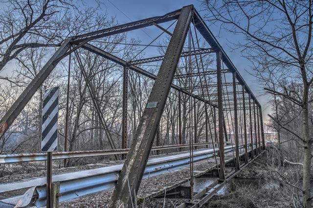
This bridge was originally built in 1886 as part of a seven span highway bridge in Attica, Indiana. In 1924, that bridge was replaced by a concrete arch bridge (see below historical photo). The 1886 truss spans were not demolished however, and instead were relocated and reused in various locations in Indiana. Several of these reused spans remain today, and this is one of them.
The spans have unusual design details including four-prong eyebars for the upper lateral bracing. Another unusual detail is that the fishbelly floorbeams are not hung from the bottom chord by u-bolts (as was typical in 1886), but are instead field bolted to the verticals. It is not known if this is original, or might be an alteration from the relocation.
HistoricBridges.org has documented another one of the Attica Bridge spans, the CR-100 Bridge.

Information and Findings From DHPA Historic Bridge SurveyStatement of Significance When the 1886 metal-truss Attica Wagon Bridge across the Wabash River was bypassed in the early 1920s with a reinforced concrete-arch structure of Indiana State Highway Commission design, the Fountain county commissioners ordered that the seven spans of the old structure be dismantled and moved to carry local roadways over streams in various other locations. As a part of the relocation, the eastern-most through-truss span of the old wagon bridge were re-erected at its current location where it has carried CR 300E over Big Shawnee Creek since 1924. Contention over the Wabash Americans used to intone the aphorism of "good fences make good neighbors" as a common-sense bit of Yankee wisdom. Apparently "rivers" could not be substituted for "fences" with equal effect. At least the Wabash River did not make good neighbors of Warren and Fountain counties in Indiana. These two could not agree to the widespread Hoosier practice of sharing between them design, construction, and maintenance costs of bridges where required on a common border. The considerable difference in kinds and amounts of natural resources, population, and wealth that each county possessed probably fueled the feuding over river crossings between Warren and Fountain counties. The feuding was certainly exacerbated by the fact that the river towns of one county were not located opposite the towns of the other. Crossing the Wabash at any one place did not advantage the two counties equally. Hence each county went it alone whenever the Wabash was spanned, and each often attempted to reclaim some payment from the residents of the other through the use of tolls. Crossing the Wabash at Attica Covered Timber-Truss Bridge (1861-1886) No river port in either county attained the size and wealth of Attica. Not surprisingly, Attica's entrepreneurs reached across the Wabash River to Warren county as hinterland. In 1861, a group of Attica leaders organized the Attica Bridge Company which in turn contracted with E. B. Hall of Toledo to build a six-span timber-truss vehicular bridge over the river. The structure served Attica until 1886 when destroyed by a tornado. Metal-Truss Wagon Bridge (1886-1922) Attica's citizens responded immediately to the destruction of the river covered bridge with a petition to the Fountain county commissioners for the immediate construction of a replacement structure. Fountain's commissioners responded promptly and affirmatively in late May 1886, and, in keeping with state law, notified the Warren county commissioners of their willingness to proceed. After the Warren county authorities had "failed and refused for a period of more than thirty days to accept or act upon same," the Fountain board appointed W. P. Bixby, a civil engineer, on 30 June to survey the site and present specifications for "a double-track iron Bridge" to be built where possible on the substructure of the old timber one. It also appointed a committee of three to superintend construction. Before adjourning, the Fountain board also declared in protest "that Fountain and Warren counties should share the expense of building the bridge jointly." Despite the refusal of the Warren county authorities to participate in the Attica Wagon Bridge project, the Fountain board did agree in 1887 to a petition from Attica leaders that passage over the new bridge should be free of tolls. The three designated superintendents had a "Notice of Letting" published in the Attica Ledger within a week of their official appointment. They, in turn, named R. Angst, the chief engineer of the Chicago and Illinois Central Railroad, to draft detailed plans and specifications for the new bridge. The superintendents received and opened bids for the substructure (three bids), earth work (two bids), and superstructure (nineteen bids) in August at the law offices of Schoonover & Reed in Attica. Having read all the superstructure bidders' proposals "carefully and made a report in writing," Angst "found that the lowest bidder did not come up to the plans and that the Milwaukee Bridge & Iron Works was the best bridge among the lowest bidders." Indeed, Angst passed over the lowest four bids. The superintendents then awarded the contract to the Wisconsin firm on the understanding that the structure would be complete within sixty days. Reinforced Concrete Arch Bridge The old wagon bridge apparently served Attica's interests well enough from 1886 until around the time of the First World War, soon after which the road and the bridge would become part of the Indiana State Highway system. By September 1919, the town's movers and shakers had gotten over 380 signatures on a petition for a new bridge. The petitioners alleged that the existing iron bridge "is insufficient to safely allow of the transportation and travel over the same." It is "in an unsafe condition, and is so constructed that the same cannot be repaired." Attica had an empire to maintain: "...at least one hundred square miles of territory in said Warren County is tributary to the city of Attica, and the same is thickly populated and the inhabitants thereof cross said bridge for the purpose of transacting business and marketing their produce." The Fountain commissioners endorsed the request of their expansive petitioners, and sent a record of their willingness to build on to the Warren county board which represented the tributary peoples across the river. In the tradition of these matters, Warren's commissioners declined to engage, and the Fountain board proceeded on alone. The story of the design and construction of the new reinforced concrete arch structure is in itself a full one, although not germane to the destiny of the metal-truss structure in process of being bypassed. The Metal Phoenix Having built the metal-truss wagon bridge with their own monies, the Fountain board could dispose of the bypassed structure as it wished without consulting the Warren county recalcitrants. While the board had conceded to the weighty Attica lobbyists' demands for a new bridge, the commissioners did not also buy into Attica hyperbole over the allegedly desperate state of the metal-truss spans. Indeed, the board ordered the county engineer, Colonel W. Sentman to plan for the dismantling and relocation of the seven river spans. Sentman's plans for "the wrecking of the steel bridge" were duly adopted in early May 1922. The editor of the Rockville Tribune noted the seeming incongruity of, on the one hand, "the engineers" -- when the proposal on the table was for the erection "of the famous $300,000 structure just completed this year" -- who cited the metal-truss spans as "unsafe and dangerous and unfit for use" and, on the other hand, the Fountain board's recent decision to relocate some of these old metal-truss spans to Cain township. None of the seven spans were relocated to Cain township. In August and October 1923, the Winamac Construction Company, a firm skilled in bridge-moving as well as in bridge-building, won the contracts for the dismantling and relocations. Hushaw Bridge (1924-date) For $1,190, Winamac agreed in October 1923 to dismantle the eastern-most through-truss span of the river bridge, and in May 1924 contracted in a combined $10,000 deal to re-erect it on CR 300E over Big Shawnee Creek in Shawnee township as well as another span over Turkey Run Creek in Davis township (Fountain #156). Since CR 300E was fairly new to the county system, there were probably no bridge at the Big Shawnee Bridge site before the relocation of the Wabash River span and therefore no existing substructure to recycle. No road was shown at this location in an 1897 map of the township, although the road's presence was clearly recorded in a 1914 map. Some matters concerning the construction of the concrete abutments for the Hushaw bridge site remain unclear. At the opening of 1923, the commissioners named J. D. Fine Boggs as the county's civil engineer to replace Col. Sentman. Boggs was a believer in having county forces perform as much bridge work as they could. Although he had his men construct the substructures for three of the structures moved from Attica, the Hushaw crossing was not identified in this group. The commissioners agreed to a May 1924 letting for concrete abutments astride Big Shawnee Creek. However, when all bids came in above the county engineer's estimate, the commissioners did not agree to a contract. Since the record does not report contracting for the substructure later either, it is likely that Boggs had his men build these abutments, too. In November, the commissioners did accept the abutments as complete to specifications. They had done the same, interestingly enough, for the superstructure three months earlier. The close cooperation suggested by this order of events between Winamac Construction and the county reinforces the hunch that county forces--not a private contractor-built the substructure. Architectural Description Seated on concrete abutments over Coal Creek, the pinned Pratt through-truss span extends (center-to-center) 128 ft. and 2 in. The end-posts and top-chord members consist of a pair of channels riveted together with a cover plate above and lacing bars below. For the end-posts, the channels are 9 in.; for the top-chord members, 8 in. The lower-chord members vary in form and size. The two outer panels carry a pair of 7-in. channels riveted together with occasional battens. The inner panels carry a pair of 4-in. wide eyebars, 7/8-in. thick in the third and sixth panels, 1 1/8-in. thick in the fourth and fifth panels. The webbing divides each truss into nine panels of approximately 14 ft. and 9 in. wide. The verticals vary from panel to panel. A pair 2-in. eyebars serve as the outer hangers. A pair of channels decreasing in size toward midspan (7 in. > 6 in. > 5 in.) are riveted together with lacing bars to provide the inner verticals. The pairs of eyebars used for the diagonals also vary in size from the second panel to midspan (3 in. > 2.5 in. > 1.75 in.). The center panel carries diagonals and counter-braces of a pair of 1.5 in. eyebars with turnbuckles. The panel on each side of center also have counter-braces of a pair of adjustable, loop-welded, 3/4-in. rods. The trusses are well braced. The portal struts consist of two pairs of angles latticed together and carrying another pair of angles as knee-braces. The internal struts are also made from two pairs of angles, laced rather than latticed together. Adjustable, square rod supply the upper and lower lateral braces. The uppers all consist of 7/8-in. rod; the lowers decrease in diameter from the end panels towards center-span (1 5/8 in. > 1 3/8-in. > 1 1/8-in. > 7/8 in.) rod. Variable-depth plate girders provide the floor-beams. They support runs of heavy I-beam steel stringers which, in turn, carry a timber deck with a 17-ft. and 6-in. roadway and 14 feet and 10 inches of vertical clearance. The trusses are lined with contemporary galvanized railings. The survey engineers of the Indiana State Highway Commission made detailed measurements of all the seven spans of the Wagon Bridge at Attica in 1921 when the structure became-temporarily-a part of the state system. The material used in the trusses remains undetermined. Given the date of construction and the references in the Fountain county records to "iron," one would expect to find the original members made of wrought iron. The relatively good condition of the members also suggests that they were fabricated from the more durable metal, wrought iron, rather than of steel. Yet, references from local records in the 1920s repeatedly refer to "steel" spans. Since few metal-truss structures remain in Indiana from the 1870s and 1880s, this span, although moved over 75 years ago, is part of an increasingly rare heritage. A prolific regional bridge-builder fabricated these spans, and an important Indiana firm that specialized in moving bridges relocated these spans with unusual expertise. The trusses retain their original members, including their decoratively latticed portal struts. The stringers, in all likelihood, were originally of timber. They were probably replaced in the 1890s with rolled steel I-beams and were then probably replaced again in the 1924 move. The original deck, likely replaced more than once before the move, was and it still is of timber. The original latticed railings have been replaced with contemporary ones. The originality in the design of these trusses is more subtle and secondary than pronounced. The variation in the size of channels between the end-posts and top-chord members, the combination of built-up members and eyebars in the lower-chord, the modulated variation in web members from panel to panel, and the design of the variable-depth plate girders are all of interest. Other Information References H. Stewart Kline & Associates, Inc., Bridge Inspection Report: Fountain County (Lafayette, 1973). Reid, Quebe, et al., Bridge Inventory & Safety Inspection: Fountain County (Indianapolis, 1979). Beam, Longest & Neff, Fountain County: Bridge Inventory Rating and Safety Inspection (Indianapolis, 2002); Fountain County: Fracture Critical Inspection Report (Indianapolis, 2006). Indiana State Highway Commission, bridge survey logs, (Records Department, INDOT, Indianapolis), 32: 50-72. Charles Cottingham, Standard Map of Fountain County, Indiana (Danville, Ill., 1897). Henry F. Ross, Attica Ledger-Press Map of Fountain County, Indiana (Ross Brothers, Publishers, Attica, 1914). bridge nameplate. George E. Gould, Indiana Covered Bridges Thru the Years (Indiana Covered Bridge Society, 1977), 19, 32, 51. Fountain County, "Commissioners Record," 11: 356-357, 400-403, 446, 542; 23: 431-432, 457-458, 461-462, 475-476, 481, 485, 502, 556, 572-577; 24: 16, 35, 41, 77, 79-80, 136, 190, 227-228, 344, 347, 490-492, 503-504, 506, 553-554, 568, 595. "Notice of Bridge Letting," "A New Bridge," 8 July 1886: p2c5, p3c4; "Bridge Bids," 12 August 1886: p3c4; Attica Ledger. The Rockville Tribune, 25 October 1922: 1. Bridge Considered Historic By Survey: Yes |
![]()
![]()
![]()
Coordinates (Latitude, Longitude):
Search For Additional Bridge Listings:
Bridgehunter.com: View listed bridges within 0.5 miles (0.8 kilometers) of this bridge.
Bridgehunter.com: View listed bridges within 10 miles (16 kilometers) of this bridge.
Additional Maps:
Google Streetview (If Available)
GeoHack (Additional Links and Coordinates)
Apple Maps (Via DuckDuckGo Search)
Apple Maps (Apple devices only)
Android: Open Location In Your Map or GPS App
Flickr Gallery (Find Nearby Photos)
Wikimedia Commons (Find Nearby Photos)
Directions Via Sygic For Android
Directions Via Sygic For iOS and Android Dolphin Browser
USGS National Map (United States Only)
Historical USGS Topo Maps (United States Only)
Historic Aerials (United States Only)
CalTopo Maps (United States Only)

© Copyright 2003-2026, HistoricBridges.org. All Rights Reserved. Disclaimer: HistoricBridges.org is a volunteer group of private citizens. HistoricBridges.org is NOT a government agency, does not represent or work with any governmental agencies, nor is it in any way associated with any government agency or any non-profit organization. While we strive for accuracy in our factual content, HistoricBridges.org offers no guarantee of accuracy. Information is provided "as is" without warranty of any kind, either expressed or implied. Information could include technical inaccuracies or errors of omission. Opinions and commentary are the opinions of the respective HistoricBridges.org member who made them and do not necessarily represent the views of anyone else, including any outside photographers whose images may appear on the page in which the commentary appears. HistoricBridges.org does not bear any responsibility for any consequences resulting from the use of this or any other HistoricBridges.org information. Owners and users of bridges have the responsibility of correctly following all applicable laws, rules, and regulations, regardless of any HistoricBridges.org information.
![]()