

View Information About HSR Ratings
This bridge was a traditional riveted pony truss bridge. The exact construction date was uncertain, it may have dated to the late 1920s or early 1930s. Depending on how the engineering of the bridge is evaluated, the design could be seen as a Pratt with counters in both center panels or a double-Warren truss.
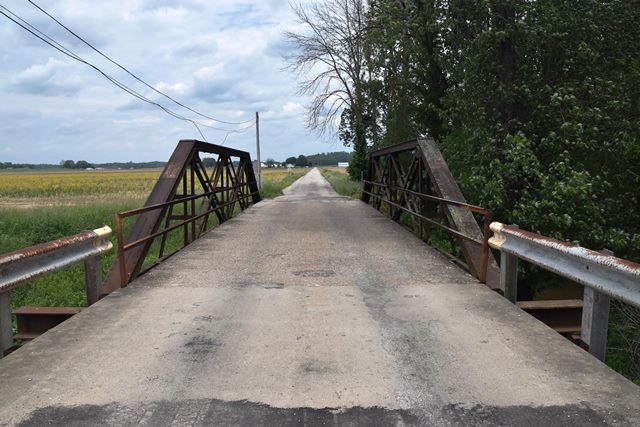
Information and Findings From DHPA Historic Bridge SurveyBridge History and Significance Sometime after Stalcup Branch was dredged into Bucher Ditch, the county commissioners contracted for a trussed span to carry what is now known as Base Road across the deeper and wider ditch. The roadway had been used as early as the 1870s primarily by the Stalcup extended family for travel between residences, shops, church, school, and marketplaces beyond. In 1903, before the dredging, the commissioners contracted for the construction of the Stalcup Bridge in Highland township. The ditch appears to have straightened the branch adjacent to the road, so the current bridge may have been the first built for the existing crossing. The design pattern suggests Vincennes Bridge Company construction in Greene County in the late 1920s or early 1930s. In 1923, the commissioners ordered and then adopted plans for the Higgins Bridge in Highland township. In August, Fred Carpenter submitted a successful $4,250 proposal for the construction of 5 structures, including the Higgins Bridge. Originally seated upon concrete abutments and wingwalls, this full-hip, riveted, Pratt pony-truss span extends 61 ft. Like many all-riveted pony trusses, this one relied heavily on angle sections. Subdividing the span into four panels, the verticals, for example, were fabricated from two pairs of angles riveted together with battens . A pair of angles riveted together with battens supply the diagonals and counters in the two center panels as well as the lower chord members. Braces added outside the trusses between the tops of the verticals and the floor-beams provide some protection against swaying which heavy, fast-moving loads can induce. The rolled I floor-beams which are riveted to the verticals support I-beam stringers and together carry the concrete deck with its 15-ft. 6-in. roadway. A pair of angles line the trusses as rails. The original concrete abutment has been cut away to the South and shell piles added to support the end of the trussed span and an I-beam approach span. The original span of this bridge represents the beginning of the last stage of pony-truss fabrication on Indiana county roadways. It was probably designed and built by the Vincennes Bridge Company, a notable Indiana fabricator which built most of Greene's County's twentieth century metal structures and others like this one (see #126). The unadorned span and the bridge setting have been altered some. The south abutment washed out in 1984, leading to the addition of an approach span and, while convenient, to replacing all the truss seats. Otherwise, the trusses retain their original members. References Butler, Fairman & Seufert, Bridge Inspection Report: Greene County (Indianapolis, 1974). M.W., Bridge Reinspection Report: Greene County (Indianapolis, 1978). United Consulting Engineers, Bridge Reinspection Report: Greene County (Indianapolis, 1981). Greene County, "Commissioners Record," U: 189; "Commissioners Docket," 17: 158, 162, 165. Bridge Considered Historic By Survey: Yes |
![]()
![]()
![]()
This historic bridge has been demolished. This map is shown for reference purposes only.
Coordinates (Latitude, Longitude):
Search For Additional Bridge Listings:
Bridgehunter.com: View listed bridges within 0.5 miles (0.8 kilometers) of this bridge.
Bridgehunter.com: View listed bridges within 10 miles (16 kilometers) of this bridge.
Additional Maps:
Google Streetview (If Available)
GeoHack (Additional Links and Coordinates)
Apple Maps (Via DuckDuckGo Search)
Apple Maps (Apple devices only)
Android: Open Location In Your Map or GPS App
Flickr Gallery (Find Nearby Photos)
Wikimedia Commons (Find Nearby Photos)
Directions Via Sygic For Android
Directions Via Sygic For iOS and Android Dolphin Browser
USGS National Map (United States Only)
Historical USGS Topo Maps (United States Only)
Historic Aerials (United States Only)
CalTopo Maps (United States Only)

© Copyright 2003-2024, HistoricBridges.org. All Rights Reserved. Disclaimer: HistoricBridges.org is a volunteer group of private citizens. HistoricBridges.org is NOT a government agency, does not represent or work with any governmental agencies, nor is it in any way associated with any government agency or any non-profit organization. While we strive for accuracy in our factual content, HistoricBridges.org offers no guarantee of accuracy. Information is provided "as is" without warranty of any kind, either expressed or implied. Information could include technical inaccuracies or errors of omission. Opinions and commentary are the opinions of the respective HistoricBridges.org member who made them and do not necessarily represent the views of anyone else, including any outside photographers whose images may appear on the page in which the commentary appears. HistoricBridges.org does not bear any responsibility for any consequences resulting from the use of this or any other HistoricBridges.org information. Owners and users of bridges have the responsibility of correctly following all applicable laws, rules, and regulations, regardless of any HistoricBridges.org information.
![]()