

View Information About HSR Ratings
This bridge is an attractive structure that has been closed and abandoned on the edge of Kellogg. From the north, an industrial area has taken over the old road, but the road remains in use south of the bridge to US-6. According to Dave Darby of the Route 6 Tourist Association, the bridge carried several important routes up until 1928, including a road called the River to River Road, Iowa Primary Road 7, the Detroit Lincoln Denver Highway, and finally US 32 until 1928.
In 2010, Dave Darby provided the following additional history about the River to River Road including the fact that the highway is now 100 years old: "It is Iowa's oldest highway, known back then as an "Auto Trail". Rather than numbers, all the routes had names, and corresponding symbols that would be painted on telephone poles along the way. The route is named such, because it spans from the Mississippi River at Davenport (Rock Island Arsenal bridge) to The Missouri River at Council Bluffs (Ak Sar Ben Bridge - non-extant) The River to River Road celebrates its 100th anniversary this year."
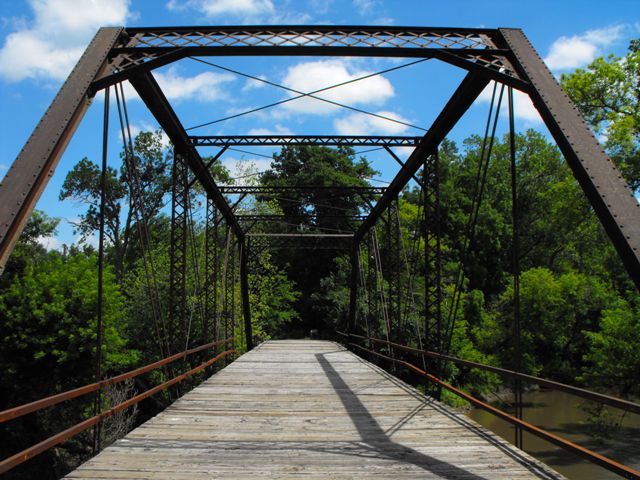
The bridge includes four metal stringer approach spans and a single six panel main truss span. The truss is traditionally composed and appears to retain excellent historic integrity. It is historically significant as a good representative example of truss bridges being built around 1900. Bridges from this period are important examples of how the period of experimentation seen in the few decades leading up to 1900 had ended and the design of pin-connected truss bridges had become standardized and lacked innovative or distinctive details when compared with other bridges from the same period. As the 20th Century began, pinned connections would then begin to fade out in favor of riveted connections.
The bridge should also be considered historically significant for its association with historic highways and historical paths of travel.
As of 2014, this historic bridge has been demolished. The county claimed it was a liability as an abandoned structure. Claims of liability are unsubstantiated by fact as research conducted by organizations like the SRI Foundation has been unable to find any frequency of lawsuits relating to historic bridges. Furthermore, many abandoned bridges nationwide remain without issues. And finally, posting of "No Trespassing" or "Use at Own Risk" types of signage may further help relieve liability.
John Hammerly was kind enough to supply the below historical photo of the bridge, which shows the bridge with original railing and builder plaque intact. The text was legible and allowed for identification of the builder of the bridge: 1898 BUILT BY MARSHALLTOWN BRIDGE AND IRON WORKS MARSHALLTOWN IA."
As documented in 2009 this bridge's truss span sat on rolled h-pile style beams. This type of beam was not in use in 1898 for substructures. Further the historical photo shows no approach spans. This suggests the bridge was raised up on new substructure at some time after the historical photo was taken, likely to provide better clearance for flood waters.

![]()
![]()
![]()
This historic bridge has been demolished. This map is shown for reference purposes only.
Coordinates (Latitude, Longitude):
Search For Additional Bridge Listings:
Bridgehunter.com: View listed bridges within 0.5 miles (0.8 kilometers) of this bridge.
Bridgehunter.com: View listed bridges within 10 miles (16 kilometers) of this bridge.
Additional Maps:
Google Streetview (If Available)
GeoHack (Additional Links and Coordinates)
Apple Maps (Via DuckDuckGo Search)
Apple Maps (Apple devices only)
Android: Open Location In Your Map or GPS App
Flickr Gallery (Find Nearby Photos)
Wikimedia Commons (Find Nearby Photos)
Directions Via Sygic For Android
Directions Via Sygic For iOS and Android Dolphin Browser
USGS National Map (United States Only)
Historical USGS Topo Maps (United States Only)
Historic Aerials (United States Only)
CalTopo Maps (United States Only)

© Copyright 2003-2024, HistoricBridges.org. All Rights Reserved. Disclaimer: HistoricBridges.org is a volunteer group of private citizens. HistoricBridges.org is NOT a government agency, does not represent or work with any governmental agencies, nor is it in any way associated with any government agency or any non-profit organization. While we strive for accuracy in our factual content, HistoricBridges.org offers no guarantee of accuracy. Information is provided "as is" without warranty of any kind, either expressed or implied. Information could include technical inaccuracies or errors of omission. Opinions and commentary are the opinions of the respective HistoricBridges.org member who made them and do not necessarily represent the views of anyone else, including any outside photographers whose images may appear on the page in which the commentary appears. HistoricBridges.org does not bear any responsibility for any consequences resulting from the use of this or any other HistoricBridges.org information. Owners and users of bridges have the responsibility of correctly following all applicable laws, rules, and regulations, regardless of any HistoricBridges.org information.
![]()