

View Information About HSR Ratings
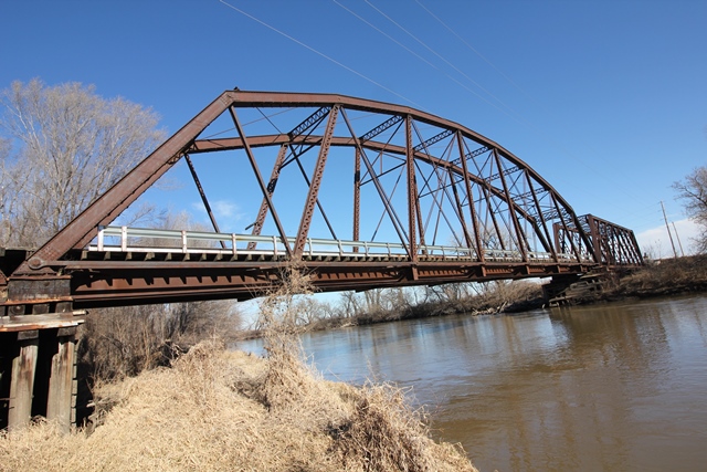
This former railroad bridge converted to highway use is one of the most significant railroad bridges in the state, containing two rare truss types in a single bridge! These two types are the Pegram truss and the triple intersection Warren (lattice) truss. Most lattice trusses in America are quadruple intersection.
A Cambria brand was found on an eyebar of this bridge. Steel mill names are rarely found on eyebars.
John Marvig provided the following comments:
Similar to Lindsborg, the [lattice truss] spans likely do not date to 1893. With the timber piers, I strongly suspect that this bridge was moved to this location, although I have not been able to confirm any build dates. I reached out to the Cloud County Roads Department this morning, and we will see if I hear back. I suspect this may be related to the Minneapolis span, as the length of the Pegram on this bridge matches the second Pegram span at Columbus, Nebraska. A December 1913 article states "The Union Pacific is erecting a new four span bridge over the Republican river, four miles east of this city .This bridge will be constructed of steel, with concrete piers and abutments, at a cost of approximately $18,000. This is the second modern bridge to be erected this year, on the Junction City branch. We may hope for a real main line railroad through Concordia at some future date". Obviously this bridge doesn't have concrete piers or four spans, but the branch and location are accurately described.
John also contacted the county who indicated that the bridge was indeed moved from an unknown location in Wyoming.
Reportedly as of 2022, this bridge will be bypassed and left standing. https://www.bladeempire.com/news/cloud-county-awarded-funds-replace-historic-bridge
This bridge is tagged with the following special condition(s): Unorganized Photos
![]()
![]()
![]()
Coordinates (Latitude, Longitude):
Search For Additional Bridge Listings:
Bridgehunter.com: View listed bridges within 0.5 miles (0.8 kilometers) of this bridge.
Bridgehunter.com: View listed bridges within 10 miles (16 kilometers) of this bridge.
Additional Maps:
Google Streetview (If Available)
GeoHack (Additional Links and Coordinates)
Apple Maps (Via DuckDuckGo Search)
Apple Maps (Apple devices only)
Android: Open Location In Your Map or GPS App
Flickr Gallery (Find Nearby Photos)
Wikimedia Commons (Find Nearby Photos)
Directions Via Sygic For Android
Directions Via Sygic For iOS and Android Dolphin Browser
USGS National Map (United States Only)
Historical USGS Topo Maps (United States Only)
Historic Aerials (United States Only)
CalTopo Maps (United States Only)

© Copyright 2003-2024, HistoricBridges.org. All Rights Reserved. Disclaimer: HistoricBridges.org is a volunteer group of private citizens. HistoricBridges.org is NOT a government agency, does not represent or work with any governmental agencies, nor is it in any way associated with any government agency or any non-profit organization. While we strive for accuracy in our factual content, HistoricBridges.org offers no guarantee of accuracy. Information is provided "as is" without warranty of any kind, either expressed or implied. Information could include technical inaccuracies or errors of omission. Opinions and commentary are the opinions of the respective HistoricBridges.org member who made them and do not necessarily represent the views of anyone else, including any outside photographers whose images may appear on the page in which the commentary appears. HistoricBridges.org does not bear any responsibility for any consequences resulting from the use of this or any other HistoricBridges.org information. Owners and users of bridges have the responsibility of correctly following all applicable laws, rules, and regulations, regardless of any HistoricBridges.org information.
![]()