We Recommend:
Bach Steel - Experts at historic truss bridge restoration.
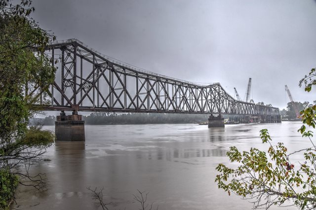
Krotz Springs Railroad Bridge

Primary Photographer(s): Nathan Holth
Bridge Documented: October 14, 2019
Krotz Springs: Pointe Coupee Parish, Louisiana and St. Landry Parish, Louisiana: United States
Metal Rivet-Connected Double-Intersection Warren Through Truss, Movable: Swing (Rim Bearing Center Pier) and Approach Spans: Metal Cantilever 16 Panel Rivet-Connected Warren Through Truss, Fixed
1908 By Builder/Contractor: Union Bridge and Construction Company of Kansas City, Missouri
2019
305.0 Feet (93 Meters)
770.0 Feet (234.7 Meters)
Not Available
1 Main Span(s) and 4 Approach Span(s)
Not Applicable

View Information About HSR Ratings
Bridge Documentation
This swing bridge had its approach redesigned with an noteworthy, and highly unusual cantilever span in 1938-1940. The bridge was originally built in 1908. Kohman and McMurray constructed the substructure and Union Bridge and Construction Company of Kansas City, Missouri built the superstructure. For the five years prior to construction of a nearby highway bridge, the bridge was modified to carry vehicular traffic as well as train traffic, from 1930-1935. A few years later, the bridge's most significant alteration took place. A desire to dredge and expand the capacity of this river required expanding the bridge with a new 721 foot extension. This extension took an unusual form. A three span cantilever structure was built, but unlike most 3 span cantilever bridges, the center span was designed as the anchor span while the end spans were cantilever arms. These cantilever arms each held one of the original fixed 1908 Double-intersection Warren through truss approach spans, turning these former simple truss spans into half-suspended spans. The project took place from 1938-1940. A sketch below shows the present configuration of the bridge. As of 2019, steel repairs were being completed on the bridge. The unusual history of the bridge means that the main span of the bridge is neither the visually largest nor the longest span on the bridge. The main span length given by HistoricBridges.org is the swing span length. The cantilever truss's largest span is about 450 feet. The cantilever unit, including the half-suspended spans is about 1,330 feet. The swing span is 305 feet, and the unaltered fixed truss span is about 295 feet. Traditionally, alterations on historic bridges reduce historic significance. With this bridge, this is not the case. The added cantilever truss span, which dates to a historical period, and represents a significant creative engineering solution, adds to the historical significance of the bridge.
View Historical Article About This Bridge
View Historical Report Discussing This Bridge
![]()
Photo Galleries and Videos: Krotz Springs Railroad Bridge
Bridge Photo-Documentation
Original / Full Size PhotosA collection of overview and detail photos. This gallery offers photos in the highest available resolution and file size in a touch-friendly popup viewer.
Alternatively, Browse Without Using Viewer
![]()
Bridge Photo-Documentation
Mobile Optimized PhotosA collection of overview and detail photos. This gallery features data-friendly, fast-loading photos in a touch-friendly popup viewer.
Alternatively, Browse Without Using Viewer
![]()
Maps and Links: Krotz Springs Railroad Bridge
Coordinates (Latitude, Longitude):
Search For Additional Bridge Listings:
Bridgehunter.com: View listed bridges within 0.5 miles (0.8 kilometers) of this bridge.
Bridgehunter.com: View listed bridges within 10 miles (16 kilometers) of this bridge.
Additional Maps:
Google Streetview (If Available)
GeoHack (Additional Links and Coordinates)
Apple Maps (Via DuckDuckGo Search)
Apple Maps (Apple devices only)
Android: Open Location In Your Map or GPS App
Flickr Gallery (Find Nearby Photos)
Wikimedia Commons (Find Nearby Photos)
Directions Via Sygic For Android
Directions Via Sygic For iOS and Android Dolphin Browser
USGS National Map (United States Only)
Historical USGS Topo Maps (United States Only)
Historic Aerials (United States Only)
CalTopo Maps (United States Only)


