

View Information About HSR Ratings
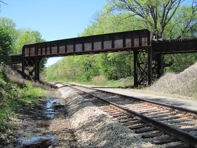
Located a short distance east of a township park, this is an uncommon railroad over railroad grade separation. This structurally unusual bridge is heavily skewed and as a result it has specially shaped triangular bents. The bridge is a crossing of two Amtrak passenger routes. The lower railway is owned by Amtrak (from Porter IN to Kalamazoo MI, the longest segment it owns outside its Northeast Corridor) and carries the Detroit and Port Huron trains to Chicago, while the upper CSX railroad line carries the Amtrak train from Grand Rapids. These routes run about a mile or two apart from here southwest 25 miles to Porter Indiana before joining together. Because of this separation, when the city of New Buffalo (1.5 miles southwest of this crossing) in 2009 moved its Amtrak station 7 blocks north from the CSX tracks to a new facility on the Amtrak line, they gained passenger access to Detroit and Port Huron, but caused the Grand Rapids train to end 15 years of stops at New Buffalo. The Amtrak line can run up to 95 mph, and they hope to boost it to 110.
An additional lower rail line obviously present when the bridge was built is now gone. The lower line was originally built as the Michigan Central (1849), and the upper line was built no earlier than 1870 (Chicago & Michigan Lake Shore). The grade separation bridge seen today would not be original to either railroad line.
![]()
![]()
![]()
Coordinates (Latitude, Longitude):
Search For Additional Bridge Listings:
Bridgehunter.com: View listed bridges within 0.5 miles (0.8 kilometers) of this bridge.
Bridgehunter.com: View listed bridges within 10 miles (16 kilometers) of this bridge.
Additional Maps:
Google Streetview (If Available)
GeoHack (Additional Links and Coordinates)
Apple Maps (Via DuckDuckGo Search)
Apple Maps (Apple devices only)
Android: Open Location In Your Map or GPS App
Flickr Gallery (Find Nearby Photos)
Wikimedia Commons (Find Nearby Photos)
Directions Via Sygic For Android
Directions Via Sygic For iOS and Android Dolphin Browser
USGS National Map (United States Only)
Historical USGS Topo Maps (United States Only)
Historic Aerials (United States Only)
CalTopo Maps (United States Only)

© Copyright 2003-2024, HistoricBridges.org. All Rights Reserved. Disclaimer: HistoricBridges.org is a volunteer group of private citizens. HistoricBridges.org is NOT a government agency, does not represent or work with any governmental agencies, nor is it in any way associated with any government agency or any non-profit organization. While we strive for accuracy in our factual content, HistoricBridges.org offers no guarantee of accuracy. Information is provided "as is" without warranty of any kind, either expressed or implied. Information could include technical inaccuracies or errors of omission. Opinions and commentary are the opinions of the respective HistoricBridges.org member who made them and do not necessarily represent the views of anyone else, including any outside photographers whose images may appear on the page in which the commentary appears. HistoricBridges.org does not bear any responsibility for any consequences resulting from the use of this or any other HistoricBridges.org information. Owners and users of bridges have the responsibility of correctly following all applicable laws, rules, and regulations, regardless of any HistoricBridges.org information.
![]()