

View Information About HSR Ratings
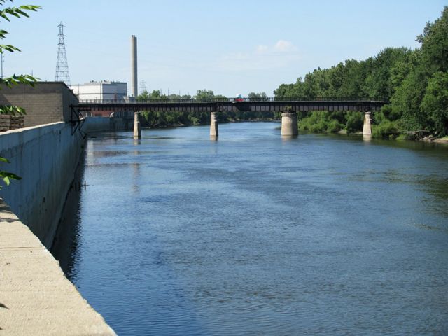
This bridge is a deck plate girder swing bridge, although for the majority of its history the bridge has functioned as a fixed bridge, since the need for movable bridges on the Grand River ended shortly after it was built. All the machinery of the swing has been removed, with only the main gear, rollers, and circular pier identifying one of the spans as a swing span. The bridge originally served the Michigan Railway, which was an electric interurban facility that also included the Gillette Bridge. The metal structures seen on the sides of the bridge are what is left of the towers that held the overhead electric lines to power the trains. The system was built to such high standards that this bridge was used by conventional trains for decades after the interurban went out of business. The bridge later stood abandoned for many years, but was converted into a rail-trail facility in 2010.
Information and Findings From Historic American Engineering Record SurveyDiscussion of Bridge This swing bridge was erected to carry the Michigan Central Railroad over Market Street and the Grand River. The builder was the Toledo Bridge and Crane Company of Toledo, Ohio. It is a simple steel girder bridge, 12 feet wide and approximately 680 feet long. it consists of two parallel steel girders, eight feet high, with six inch steel I'beams as crossmembers supporting the roadbed. There are four spans resting on concrete piers and abutments. Proceeding from east to west, the first span (crossing Market Street and extending over the Grand River) is 200 feet long, the next span is 100 feet long, the swing span in 200 feet long, and finally, the westernmost span is l80 feet in length. The swing span is no longer moveable and the line itself has been abandoned for at least a decade. |
![]()
![]()
![]()
Coordinates (Latitude, Longitude):
Search For Additional Bridge Listings:
Bridgehunter.com: View listed bridges within 0.5 miles (0.8 kilometers) of this bridge.
Bridgehunter.com: View listed bridges within 10 miles (16 kilometers) of this bridge.
Additional Maps:
Google Streetview (If Available)
GeoHack (Additional Links and Coordinates)
Apple Maps (Via DuckDuckGo Search)
Apple Maps (Apple devices only)
Android: Open Location In Your Map or GPS App
Flickr Gallery (Find Nearby Photos)
Wikimedia Commons (Find Nearby Photos)
Directions Via Sygic For Android
Directions Via Sygic For iOS and Android Dolphin Browser
USGS National Map (United States Only)
Historical USGS Topo Maps (United States Only)
Historic Aerials (United States Only)
CalTopo Maps (United States Only)

© Copyright 2003-2024, HistoricBridges.org. All Rights Reserved. Disclaimer: HistoricBridges.org is a volunteer group of private citizens. HistoricBridges.org is NOT a government agency, does not represent or work with any governmental agencies, nor is it in any way associated with any government agency or any non-profit organization. While we strive for accuracy in our factual content, HistoricBridges.org offers no guarantee of accuracy. Information is provided "as is" without warranty of any kind, either expressed or implied. Information could include technical inaccuracies or errors of omission. Opinions and commentary are the opinions of the respective HistoricBridges.org member who made them and do not necessarily represent the views of anyone else, including any outside photographers whose images may appear on the page in which the commentary appears. HistoricBridges.org does not bear any responsibility for any consequences resulting from the use of this or any other HistoricBridges.org information. Owners and users of bridges have the responsibility of correctly following all applicable laws, rules, and regulations, regardless of any HistoricBridges.org information.
![]()